kpac home
  • Home
  • Snowpack
    • Get The Forecast
    • Alerts Sign-up
    • Historic Snowpack Summary Archive
    • Observations
    • Submit Observation
    • Snowpack Data (snowpilot.org)
    • KPAC Backcountry Group
    • RAC Project
  • Weather
    • NWS Flagstaff Area Forecast Discussion
    • NWS Treeline Forecast (~11,500')
    • NWS Near Treeline Forecast (~10,900')
    • NWS Below Treeline Forecast (~10,000')
    • GFS Model Guidance
    • NBM Model Guidance
    • Precipitation Analysis
    • GOES (satellite) Image Viewer
    • AZ Snowbowl Top Patrol (ASBTP)
    • AZ Snowbowl Top of Grand Canyon Express Lift (AU373)
    • AZ Snowbowl Primary Pump House (ASBSB)
    • AZ Snowbowl Little Spruce Station (ASBLS)
    • Snowslide Canyon SNOTEL - 7 day summary
    • Snowslide Canyon SNOTEL - 72 hour summary
    • Snowslide Canyon SNOTEL - 72 hour time series viewer
    • Snowslide Canyon SNOTEL - current water year plot
    • SNOTEL - Station/Basin Status Map
    • Flagstaff Airport Station
    • Flagstaff Alert Data (JEFDAQ)
    • Holfuy Stations
    • Snowbowl Webcams
    • NAU Webcam
    • NWS Peaks Webcam
  • Education
    • KPAC Courses
    • Scholarship Information
    • Free Online Avalanche Awareness Course
    • Avalanche.org Avalanche Basics
    • Rescue at Cherry Bowl
    • Avalanche at Tunnel Creek
    • Snow Avalanches on the San Francisco Peaks
    • Avalanches in Arizona?
    • Avalanche Awareness in the Kachina Peaks Wilderness (youtube)
    • Know Before You Go (kbyg.org)
  • Resources
    • Snow, Weather, and Avalanches observational Guidelines (SWAG)
    • Maps
    • Forest Roads Status (fs.usda.gov)
    • ADOT Travel Alerts (az511.com)
    • KPAC Logos
  • About
    • Mission
    • Donate/Sponsor
    • Newsletter
    • Team
    • Contact
    • Bylaws

Major Snow Avalanche Zones Map for the San Francisco Peaks, Coconino County, Arizona
L.R. Dexter © - Updated 2011

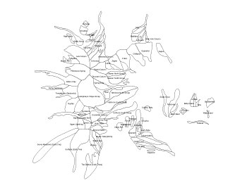
The map is made available as a public service to enhance the awareness of snow avalanches on the San Francisco Peaks. The map is designed to illustrate areas of potential major snow avalanche activity. Since avalanches can occur on very short and localized slopes, this map does not show every possible location where an avalanche can occur. In addition, the original study was limited to elevations above 8000’. A good example of avalanche terrain not included on this map can be found along the Lockett Meadow Road where heavy snow years have produced small slab avalanches on slopes above the road.
Snow Avalanches on the San Francisco Peaks
Descriptive key and metadata

major avalanche zones
avalanche zone names
sponsors

facebook/kachinapeaksavy

instagram/kachinapeaksavy
  • Home
  • Get The Forecast
  • Submit Observation
  • Courses
  • Alerts
  • Newsletter
  • Mission
  • Donate/Sponsor
  • Contact

KPAC is authorized to operate on the Coconino National Forest under a Special Use Permit

© 2025 Kachina Peaks Avalanche Center - KPAC