Snowpack Summary for Saturday, January 28, 2017 11:46 AM Dangerous and Reactive Wind Slabs Exist Above Treeline
This summary expired Jan. 30, 2017 11:46 AM
Flagstaff, Arizona - Backcountry of The San Francisco Peaks and Kachina Peaks Wilderness
Evidence of natural avalanches were seen in Humphrey's cirque and reports came in that a 6 ft crownline was observed in Snowslide Canyon. These most likely ran sometime between Saturday and Monday during our winter storm trifecta, January 20-23, 2017. This storm cycle produced 93" of snow and almost 7" of water, which is a significant weight on the previously fragile snowpack.
Reactive wind slabs are actively forming near and above treeline. Human triggered and natural avalanches are possible in wind affected terrain.
Avalanche starting zones above 1st and 2nd Gully, on Agassiz Peak are wind loaded and have reactive hard wind slabs. This terrain is easily accessed from the top of the Agassiz Chairlift at the Arizona Snowbowl. The backcountry access point at the ski area is at treeline, which obscures the view of the loaded slide paths above. Hard slabs are a common cause of avalanche fatalities, particularly those involving traumatic injuries. Wind slab avalanches can be triggered naturally by wind loading, which is currently occurring, or by the weight of a skier or rider.
Trend: Considering the cold temperatures we are currently experiencing, wind slab reactivity may linger longer than usual.
Some reactive soft windslabs (fist+ to four finger-) were found near 12000 ft on easterly slopes of Humphrey's Cirque. These are the avalanche slopes often used for the hike/skin out of Humphrey's Cirque to the low saddle and back to Az Snowbowl. In some spots along the skin track where the slab was harder, we observed windslab propagation potential in some quick pits. ECTP10, sudden collapse about 15cm down. Fortunately the slab hardness was quite variable, mostly soft, and not very consistently cohesive. However these windslabs have matured and become more consistently reactive with the continued winds.
Negative 30°F or less windchills have been reported today at the Agassiz Weather Station. COLD.
Some cornice formation was observed, and perhaps growing with the persistent winds... keep this in mind as you near steep ridgetop edges for a closer look.
Current Problems (noninclusive) more info

Images
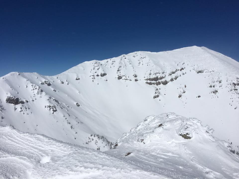
Humphrey's cirque on January 26, 2017. Lots of new wind loaded snow, your main avalanche problem for the weekend. Photo by Josh Langdon
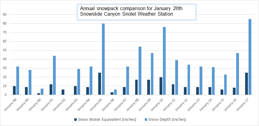
On January 26th the snotel had a base of 85 inches, THE DEEPEST it has ever seen on this date since it started reporting in the fall of 1997!
Final Thoughts
Travelers are advised to exercise caution and make slope specific evaluations. As always, please treat this summary with appropriately guarded skepticism, make your own assessments, and contribute to our body of knowledge by reporting your observations.
Arizona Snowbowl uphill policy.
Want to learn more safe backcountry habits? KPAC offers level I and II avalanche courses. They are filling up fast!!!
During winter, backcountry permits are required to access the Kachina Peaks Wilderness. More info
Weather
Gradual warming will start on Sunday and continue through most of the week. Several minor disturbances are on the horizon for late in the week, but at this point these seem to lack sufficient moisture to produce significant precipitation.
Weather station information:
On the morning of Friday January 27th the Inner Basin SNOTEL site (Snowslide) reported a snow depth of 85 inches (216 cm) at 9700’, and Arizona Snowbowl reported 105 inches (162 cm) at 10,800’. Since January 21th, SNOTEL temperatures ranged between 1° and 34° F, and Agassiz station between -5 and 22° F.
Authored/Edited By: Derik Spice, David Lovejoy, Troy Marino
Avalanche Problems/Characters
The avalanche problem/character describes part of the current avalanche danger. However because we only realease a summary once a week, the current avalanche problem will likely change.
Understanding avalanche problems is essential, because it allows you to determine your approach and strategies to risk treatment. Below are brief descriptions of avalanche problems/characters, and links to detailed information on the problem, formation, patterns, recognition, and avoidance strategies.
Avalanche Problems Explained
Also see the North American Danger Scale.
Loose Dry

Release of dry unconsolidated snow. These avalanches typically occur within layers of soft snow near the surface of the snowpack. Loose-dry avalanches start at a point and entrain snow as they move downhill, forming a fan-shaped avalanche. Other names for loose-dry avalanches include point-release avalanches or sluffs. Loose-dry avalanches can trigger slab avalanches that break into deeper snow layers.
Loose Dry avalanches are usually relatively harmless to people. They can be hazardous if you are caught and carried into or over a terrain trap (e.g. gully, rocks, dense timber, cliff, crevasse) or down a long slope. Avoid traveling in or above terrain traps when Loose Dry avalanches are likely. more info
Storm Slab

Release of a soft cohesive layer (a slab) of new snow that breaks within the storm snow or on the old snow surface. Storm-slab problems typically last between a few hours and few days. Storm-slabs that form over a persistent weak layer (surface hoar, depth hoar, or near-surface facets) may be termed Persistent Slabs or may develop into Persistent Slabs.
You can reduce your risk from Storm Slabs by waiting a day or two after a storm before venturing into steep terrain. Storm slabs are most dangerous on slopes with terrain traps, such as timber, gullies, over cliffs, or terrain features that make it difficult for a rider to escape off the side. more info
Wind Slab
Release of a cohesive layer of snow (a slab) formed by the wind. Wind typically transports snow from the upwind sides of terrain features and deposits snow on the downwind side. Wind slabs are often smooth and rounded and sometimes sound hollow, and can range from soft to hard. Wind slabs that form over a persistent weak layer (surface hoar, depth hoar, or near-surface facets) may be termed Persistent Slabs or may develop into Persistent Slabs.
Wind Slabs form in specific areas, and are confined to lee and cross-loaded terrain features. They can be avoided by sticking to sheltered or wind-scoured areas. more info
Persistent Slab

Release of a cohesive layer of soft to hard snow (a slab) in the middle to upper snowpack, when the bond to an underlying persistent weak layer breaks. Persistent layers include: surface hoar, depth hoar, near-surface facets, or faceted snow. Persistent weak layers can continue to produce avalanches for days, weeks or even months, making them especially dangerous and tricky. As additional snow and wind events build a thicker slab on top of the persistent weak layer, this avalanche problem may develop into a Deep Persistent Slab.
The best ways to manage the risk from Persistent Slabs is to make conservative terrain choices. They can be triggered by light loads and weeks after the last storm. The slabs often propagate in surprising and unpredictable ways. This makes this problem difficult to predict and manage and requires a wide safety buffer to handle the uncertainty. more info
Deep Persistent Slab

Release of a thick cohesive layer of hard snow (a slab), when the bond breaks between the slab and an underlying persistent weak layer, deep in the snowpack or near the ground. The most common persistent weak layers involved in deep, persistent slabs are depth hoar or facets surrounding a deeply buried crust. Deep Persistent Slabs are typically hard to trigger, are very destructive and dangerous due to the large mass of snow involved, and can persist for months once developed. They are often triggered from areas where the snow is shallow and weak, and are particularly difficult to forecast for and manage. They commonly develop when Persistent Slabs become more deeply buried over time.
Deep Persistent Slabs are destructive and deadly events that can take months to stabilize. You can trigger them from well down in the avalanche path, and after dozens of tracks have crossed the slope. more info
Loose Wet

Release of wet unconsolidated snow or slush. These avalanches typically occur within layers of wet snow near the surface of the snowpack, but they may quickly gouge into lower snowpack layers. Like Loose Dry Avalanches, they start at a point and entrain snow as they move downhill, forming a fan-shaped avalanche. They generally move slowly, but can contain enough mass to cause significant damage to trees, cars or buildings. Other names for loose-wet avalanches include point-release avalanches or sluffs. Loose Wet avalanches can trigger slab avalanches that break into deeper snow layers.
Travel when the snow surface is colder and stronger. Plan your trips to avoid crossing on or under very steep slopes in the afternoon. Move to colder, shadier slopes once the snow surface turns slushly. Avoid steep, sunlit slopes above terrain traps, cliffs areas and long sustained steep pitches. more info
Wet Slab

Release of a cohesive layer of snow (a slab) that is generally moist or wet when the flow of liquid water weakens the bond between the slab and the surface below (snow or ground). They often occur during prolonged warming events and/or rain-on-snow events. Wet Slabs can be very destructive.
Avoid terrain where and when you suspect Wet Slab avalanche activity. Give yourself a wide safety buffer to handle the uncertainty. more info
Cornice Fall

Cornice Fall is the release of an overhanging mass of snow that forms as the wind moves snow over a sharp terrain feature, such as a ridge, and deposits snow on the downwind (leeward) side. Cornices range in size from small wind lips of soft snow to large overhangs of hard snow that are 30 feet (10 meters) or taller. They can break off the terrain suddenly and pull back onto the ridge top and catch people by surprise even on the flat ground above the slope. Even small cornices can have enough mass to be destructive and deadly. Cornice Fall can entrain loose surface snow or trigger slab avalanches.
Cornices can never be trusted and avoiding them is necessary for safe backcountry travel. Stay well back from ridge line areas with cornices. They often overhang the ridge edge can be triggered remotely. Avoid areas underneath cornices. Even small Cornice Fall can trigger a larger avalanche and large Cornice Fall can easily crush a human. Periods of significant temperature warm-up are times to be particularly aware.
Large cornices are generally rare in Arizona, but they have been observed during very snowy winters. more info
Glide

Release of the entire snow cover as a result of gliding over the ground. Glide avalanches can be composed of wet, moist, or almost entirely dry snow. They typically occur in very specific paths, where the slope is steep enough and the ground surface is relatively smooth. The are often proceeded by full depth cracks (glide cracks), though the time between the appearance of a crack and an avalanche can vary between seconds and months. Glide avalanches are unlikely to be triggered by a person, are nearly impossible to forecast, and thus pose a hazard that is extremely difficult to manage.
Predicting the release of Glide Avalanches is very challenging. Because Glide Avalanches only occur on very specific slopes, safe travel relies on identifying and avoiding those slopes. Glide cracks are a significant indicator, as are recent Glide Avalanches.
Glide avalanches are very uncommon in Arizona. more info
