Snowpack Summary for Friday, February 24, 2017 6:45 PM The seasonal average snowfall of 260" occurred this week...Congratulations!
This summary expired Feb. 26, 2017 6:45 PM
Flagstaff, Arizona - Backcountry of The San Francisco Peaks and Kachina Peaks Wilderness
Overall
Avalanche conditions continue to moderate. Snowpack structure on the most avalanche prone slopes is poor to moderate; snowpack strength is moderate to high, and propagation potential is moderate to low. Additional precipitation and westerly winds forecast for Sunday, February 26, may transport enough snow to produce wind slabs and unstable conditions.
The President's Day weekend storm laid down 12-14 inches of fairly high density new snow. As a result, on February 19th seasonal snowfall this year exceeded the winter average of 260 inches at Snowbowl mid mountain (10,800').
On President's Day, February 20, skiers in the Inner Basin observed small and medium sized avalanches in the vicintiy of Humphrey's Cirque. These most likely released naturally during the storm cycle on Saturday or Sunday; new snow sliding on the old snow underneath or on near surface facets within the upper 20-30 cm of the pre-storm snowpack. Avalanche control work at the Arizona Snowbowl on the same day released shallow wind slabs on northwest aspects.
Strong winds on Wednesday from the west may have transported and loaded storm snow from President's Day weekend onto east facing leeward slopes and cross-loaded gullies.
Storm snow has stabilized, however wind slab deposited on Wednesday may remain sensitive and prone to skier triggering. Although a new storm is forecast to arrive on Sunday is not expected to produce significant precipitation. If forecasted precipitation is exceeded, avalanche hazards will rise.
The President's Day storm was followed by warming conditions on Monday and Tuesday. On Wednesday, strong winds out of the west were recorded as a cold front passed north of our region, ushering in cold and breezy conditions later in the week. On the horizon, a storm is forecasted to arrive by Sunday, however moisture is modest and heavy snowfall seems unlikely. If new snow exceeds forecasted amounts or is transported by wind, avalanche hazard will increase.
The President's Day storm was followed by warming conditions on Monday and Tuesday. On Wednesday, strong winds out of the west were recorded as a cold front passed north of our region, ushering in cold and breezy conditions later in the week. On the horizon, a storm is forecasted to arrive by Sunday, however moisture is modest and heavy snowfall seems unlikely. If new snow exceeds forecasted amounts or is transported by wind, avalanche hazard will increase.
Near and Above TreelineThe forecast for Sunday, February 26, may produce a few inches of new snow at higher elevations, with wind from the west and southwest, thus loading the east and northeast aspects.
On thin northerly aspects, wind slabs may be resting on weak near surface facets that started developing during this weeks cold and clear evenings. The warm/cold imbalance has created a temperature gradient that encourages facet growth. Recent pit analysis reveals a lingering strong temperature gradient in the top 20 -30 cm of the snowpack. Facets will continue to develop 20 - 30 cm below the old snow surface, potentially creating a persistent weak layer upon which new storm and wind slab will rest.
On thin northerly aspects, wind slabs may be resting on weak near surface facets that started developing during this weeks cold and clear evenings. The warm/cold imbalance has created a temperature gradient that encourages facet growth. Recent pit analysis reveals a lingering strong temperature gradient in the top 20 -30 cm of the snowpack. Facets will continue to develop 20 - 30 cm below the old snow surface, potentially creating a persistent weak layer upon which new storm and wind slab will rest.
Below TreelineSun and radiation affected slopes developed melt/freeze crusts, and continued cold temperatures this week are preserving these crusts and rigid snow surface on south facing terrain. A rain event on Tuesday brought a freezing surface layer up to 10,000' on the west side of the Peaks.
Shaded aspects continue to provide excellent skiing opportunities above 10,000'.
Coverage is great above 9000'. The warm temps have melted much of our snow below 8000', especially on sunny slopes.
Shaded aspects continue to provide excellent skiing opportunities above 10,000'.
Coverage is great above 9000'. The warm temps have melted much of our snow below 8000', especially on sunny slopes.
Current Problems (noninclusive) more info

New snow may create storm and wind slabs, especially above treeline. Even with light precipitation amounts, wind can deposit significant amounts of snow on leeward slopes, as well as cross load gullies and chutes.
Wind slabs usually stabilize in less than a week. Reduce your exposure to avalanche hazard by waiting several days after a big loading event.
Wind slabs usually stabilize in less than a week. Reduce your exposure to avalanche hazard by waiting several days after a big loading event.
Always keep in mind, wind slabs are unpredictable, and may support the weight of a skier or rider initially, and fail suddenly with tragic consequences. Avoid snow surfaces which are recently loaded, sound hollow, have signs of fracturing, cracking, or whoompfing sounds.

If new snowfall reaches or exceeds maximum depths forecasted, storm slab and wind slab avalanches may become likely. The development of near surface facets at the boundary of new and old snow could turn a storm slab concern into a persistent slab problem.
Images

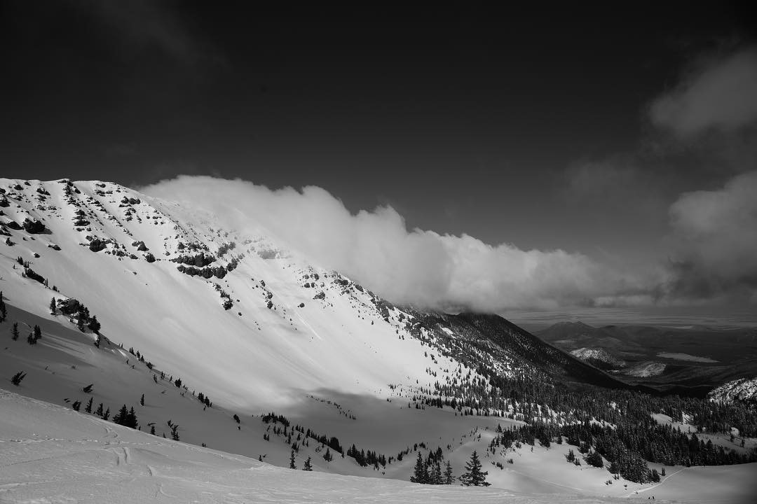
Make objective observations of current and changing conditions, and incorporate these into your flexible plan. Forecast what may happen next. Photo by Nico Barraza.
Final Thoughts
This season numerous rescues have been conducted by Coconino County Search and Rescue, and the Arizona Snowbowl Ski Patrol. Some of these could have been avoided by better planning and preparation.
Travelers are advised to exercise caution, make slope specific evaluations and most of all, know where you are going and be prepared for the unexpected.
As always, please treat this summary with appropriately guarded skepticism, make your own assessments, and contribute to our body of knowledge by reporting your observations.
Arizona Snowbowl uphill policy.
Want to learn more safe backcountry habits? KPAC offers level I and II avalanche courses. There is one class left this season.
During winter, backcountry permits are required to access the Kachina Peaks Wilderness. More info
Weather
Last updated on Friday, February 24, 2017.
Normal seasonal temperatures, and variable gusty winds out of the south-southwest and west followed the President’s Day weekend storm. Wind velocities exceeded 30 mph on Wednesday February 22nd and shifted to a northerly direction on Thursday and continued ever since. Cold temperatures and wind chill to -18° F was reported at the Agassiz Peak Station on Friday morning February 24th. Light precipitation will return to our region on Sunday, Monday and Tuesday accompanied by strong winds out of the west and southwest, as a series of short wave disturbances pass through. These appear to be lacking in moisture and are not expected to deliver more than a few inches of snow at higher elevations. Mostly clear skies and near normal temperatures will prevail for the rest of the week.
On the morning of Friday, February 24th the Inner Basin SNOTEL site (Snowslide) reported a snow depth of 76 inches (193 cm) at 9700’, and Arizona Snowbowl reported 92 inches (234 cm) at 10,800'. These values are expected somewhat to increase as precipitation starts to fall during the weekend and into next week. Since February 17th SNOTEL temperatures ranged between 13° and 47° F and Agassiz station between 0° and 34° F.
Authored/Edited By: Derik Spice, David Lovejoy, Troy Marino


