Snowpack Summary for Friday, March 10, 2017 11:26 AM Wind Affected Areas and Wet Avalanches
This summary expired Mar. 12, 2017 11:26 AM
Flagstaff, Arizona - Backcountry of The San Francisco Peaks and Kachina Peaks Wilderness
On March 8th, small loose wet snow avalanches released on southern aspects, above treeline in Humphreys Cirque. No large natural avalanches reported since the Feb. 27/28 storm. No backcountry travel triggered avalanches reported since January.
A warming trend and strong winds from the S/SW to W/NW has created variable and hazardous conditions; including but not limited to hard wind slabs on crusts and near surface faceted layers, and solar radiation creating and potentially detaching wet slabs on weak layers.
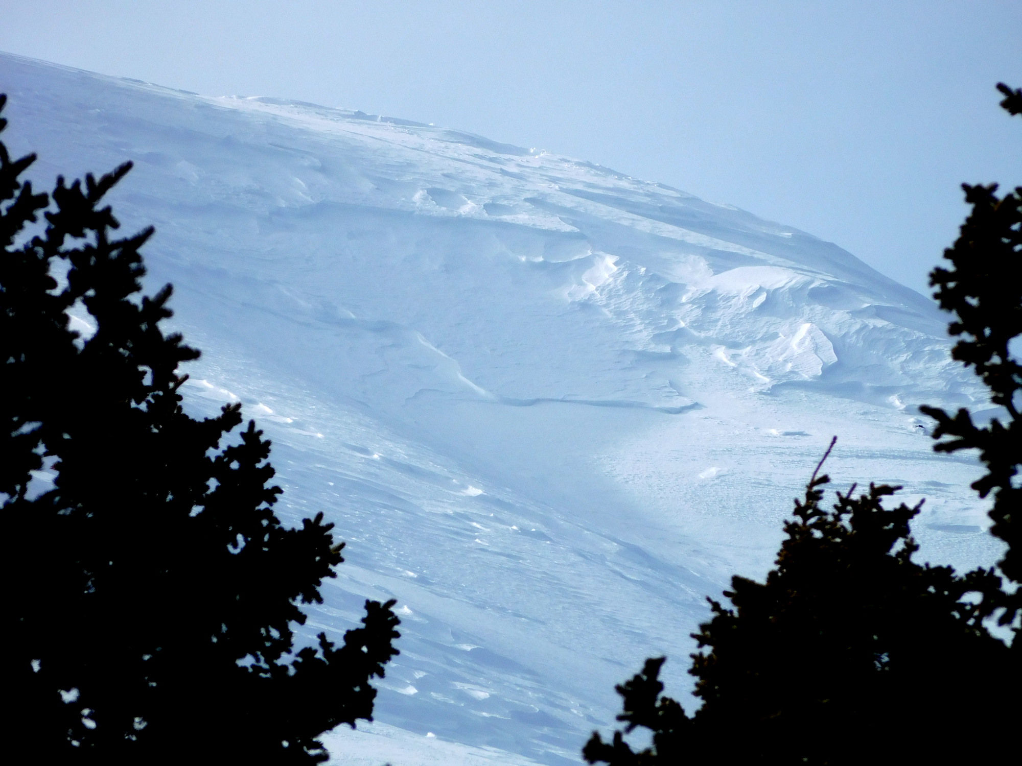
Wind loading on N to NE slopes below ridge lines was influenced by SW winds (25-35 mph) occurring over 3/4 -3/5. These winds contributed to cornice building along ridges adding to the potential hazard of cornice collapse.
Hard wind slab and rime ice may be found above treeline. Ice axes and crampons may help prevent a slide for life on steep icy slopes. Much of the snow above treeline and some below has been wind affected.
Dangerous overhung cornices with large cracks have been observed on Humphreys Peak Ridge and Hardcore Ridge. These are fairly unusual locally, at least in terms of the extent of overhanging structure. Don't be caught off guard! Cornices can be extremely dangerous as they can collapse under the weight of a person, or with warming temperatures, and potentially trigger avalanches on slopes below. When traveling on ridges, give cornices wide berth, by using route finding well to the windward side of the ridge.
Unstable wet snow may develop as treeline temperatures push 50° F. These conditions will be found primarily on southerly and westerly aspects. First at lower elevations, and then progressing towards treeline and above treeline into open terrain. Wind slabs on any aspect may become more sensitive if the slope receives significant solar input.
With temperatures projected to stay high over the next week, the possibility exists for skier triggered avalanches in warm wet snow. Possibly producing small to large slides as conditions warm.
Current Problems (noninclusive) more info

Below treeline temperatures will be even warmer, possibly creating dangerous isothermic conditions and/or potential slab releases on isolated steep slopes.

Images
We found windslabs and possible crown line on easterly slopes of Agassiz Peak on March 8. This may have slid during the late Feb. storm or during wind loading events over the past week.
Final Thoughts
Travelers are advised to exercise caution, make slope specific evaluations and most of all, know where you are going and be prepared for the unexpected.
As always, please treat this summary with appropriately guarded skepticism, make your own assessments, and contribute to our body of knowledge by reporting your observations.
Arizona Snowbowl uphill policy.
During winter, backcountry permits are required to access the Kachina Peaks Wilderness. More info
Weather
Strong to moderate winds blew from nearly all directions earlier this week before a warming trend took hold. Expect well above normal temperatures and dry conditions through the early part of next week. Expect temperatures to be 10 to 15° F above normal. Over the next 7 days fair conditions will dominate, but weak disturbances brushing past the region may occasionally result in breezy southwesterly winds.
On Thursday evening, March 2nd the Inner Basin SNOTEL site (Snowslide) reported a snow depth of 82 inches (208 cm) at 9700’, and Arizona Snowbowl reported 99 inches (251 cm) at 10800'. Since March 3rd SNOTEL temperatures ranged between 2° and 55° F and Agassiz station between 5° and 47° F.
Authored/Edited By: Derik Spice, David Lovejoy, Troy Marino
Avalanche Problems/Characters
The avalanche problem/character describes part of the current avalanche danger. However because we only realease a summary once a week, the current avalanche problem will likely change.
Understanding avalanche problems is essential, because it allows you to determine your approach and strategies to risk treatment. Below are brief descriptions of avalanche problems/characters, and links to detailed information on the problem, formation, patterns, recognition, and avoidance strategies.
Avalanche Problems Explained
Also see the North American Danger Scale.
Loose Dry

Release of dry unconsolidated snow. These avalanches typically occur within layers of soft snow near the surface of the snowpack. Loose-dry avalanches start at a point and entrain snow as they move downhill, forming a fan-shaped avalanche. Other names for loose-dry avalanches include point-release avalanches or sluffs. Loose-dry avalanches can trigger slab avalanches that break into deeper snow layers.
Loose Dry avalanches are usually relatively harmless to people. They can be hazardous if you are caught and carried into or over a terrain trap (e.g. gully, rocks, dense timber, cliff, crevasse) or down a long slope. Avoid traveling in or above terrain traps when Loose Dry avalanches are likely. more info
Storm Slab

Release of a soft cohesive layer (a slab) of new snow that breaks within the storm snow or on the old snow surface. Storm-slab problems typically last between a few hours and few days. Storm-slabs that form over a persistent weak layer (surface hoar, depth hoar, or near-surface facets) may be termed Persistent Slabs or may develop into Persistent Slabs.
You can reduce your risk from Storm Slabs by waiting a day or two after a storm before venturing into steep terrain. Storm slabs are most dangerous on slopes with terrain traps, such as timber, gullies, over cliffs, or terrain features that make it difficult for a rider to escape off the side. more info
Wind Slab
Release of a cohesive layer of snow (a slab) formed by the wind. Wind typically transports snow from the upwind sides of terrain features and deposits snow on the downwind side. Wind slabs are often smooth and rounded and sometimes sound hollow, and can range from soft to hard. Wind slabs that form over a persistent weak layer (surface hoar, depth hoar, or near-surface facets) may be termed Persistent Slabs or may develop into Persistent Slabs.
Wind Slabs form in specific areas, and are confined to lee and cross-loaded terrain features. They can be avoided by sticking to sheltered or wind-scoured areas. more info
Persistent Slab

Release of a cohesive layer of soft to hard snow (a slab) in the middle to upper snowpack, when the bond to an underlying persistent weak layer breaks. Persistent layers include: surface hoar, depth hoar, near-surface facets, or faceted snow. Persistent weak layers can continue to produce avalanches for days, weeks or even months, making them especially dangerous and tricky. As additional snow and wind events build a thicker slab on top of the persistent weak layer, this avalanche problem may develop into a Deep Persistent Slab.
The best ways to manage the risk from Persistent Slabs is to make conservative terrain choices. They can be triggered by light loads and weeks after the last storm. The slabs often propagate in surprising and unpredictable ways. This makes this problem difficult to predict and manage and requires a wide safety buffer to handle the uncertainty. more info
Deep Persistent Slab

Release of a thick cohesive layer of hard snow (a slab), when the bond breaks between the slab and an underlying persistent weak layer, deep in the snowpack or near the ground. The most common persistent weak layers involved in deep, persistent slabs are depth hoar or facets surrounding a deeply buried crust. Deep Persistent Slabs are typically hard to trigger, are very destructive and dangerous due to the large mass of snow involved, and can persist for months once developed. They are often triggered from areas where the snow is shallow and weak, and are particularly difficult to forecast for and manage. They commonly develop when Persistent Slabs become more deeply buried over time.
Deep Persistent Slabs are destructive and deadly events that can take months to stabilize. You can trigger them from well down in the avalanche path, and after dozens of tracks have crossed the slope. more info
Loose Wet
Release of wet unconsolidated snow or slush. These avalanches typically occur within layers of wet snow near the surface of the snowpack, but they may quickly gouge into lower snowpack layers. Like Loose Dry Avalanches, they start at a point and entrain snow as they move downhill, forming a fan-shaped avalanche. They generally move slowly, but can contain enough mass to cause significant damage to trees, cars or buildings. Other names for loose-wet avalanches include point-release avalanches or sluffs. Loose Wet avalanches can trigger slab avalanches that break into deeper snow layers.
Travel when the snow surface is colder and stronger. Plan your trips to avoid crossing on or under very steep slopes in the afternoon. Move to colder, shadier slopes once the snow surface turns slushly. Avoid steep, sunlit slopes above terrain traps, cliffs areas and long sustained steep pitches. more info
Wet Slab

Release of a cohesive layer of snow (a slab) that is generally moist or wet when the flow of liquid water weakens the bond between the slab and the surface below (snow or ground). They often occur during prolonged warming events and/or rain-on-snow events. Wet Slabs can be very destructive.
Avoid terrain where and when you suspect Wet Slab avalanche activity. Give yourself a wide safety buffer to handle the uncertainty. more info
Cornice Fall

Cornice Fall is the release of an overhanging mass of snow that forms as the wind moves snow over a sharp terrain feature, such as a ridge, and deposits snow on the downwind (leeward) side. Cornices range in size from small wind lips of soft snow to large overhangs of hard snow that are 30 feet (10 meters) or taller. They can break off the terrain suddenly and pull back onto the ridge top and catch people by surprise even on the flat ground above the slope. Even small cornices can have enough mass to be destructive and deadly. Cornice Fall can entrain loose surface snow or trigger slab avalanches.
Cornices can never be trusted and avoiding them is necessary for safe backcountry travel. Stay well back from ridge line areas with cornices. They often overhang the ridge edge can be triggered remotely. Avoid areas underneath cornices. Even small Cornice Fall can trigger a larger avalanche and large Cornice Fall can easily crush a human. Periods of significant temperature warm-up are times to be particularly aware.
Large cornices are generally rare in Arizona, but they have been observed during very snowy winters. more info
Glide

Release of the entire snow cover as a result of gliding over the ground. Glide avalanches can be composed of wet, moist, or almost entirely dry snow. They typically occur in very specific paths, where the slope is steep enough and the ground surface is relatively smooth. The are often proceeded by full depth cracks (glide cracks), though the time between the appearance of a crack and an avalanche can vary between seconds and months. Glide avalanches are unlikely to be triggered by a person, are nearly impossible to forecast, and thus pose a hazard that is extremely difficult to manage.
Predicting the release of Glide Avalanches is very challenging. Because Glide Avalanches only occur on very specific slopes, safe travel relies on identifying and avoiding those slopes. Glide cracks are a significant indicator, as are recent Glide Avalanches.
Glide avalanches are very uncommon in Arizona. more info
