Snowpack Summary for Friday, March 3, 2017 1:23 PM A week of Snow, Wind, Cornices and Avalanches.
This summary expired Mar. 05, 2017 1:23 PM
Flagstaff, Arizona - Backcountry of The San Francisco Peaks and Kachina Peaks Wilderness
NW, N , NE, and E aspects avalanched during the February 27/28 storm. Similar slopes that did not avalanche during the February 27/28 storm should be considered suspect. Some of the avalanches filled back in with windblown snow, potentially reburying weak layers with a new load. Ski and skin tracks may be found on these suspect slopes, but this does not prove that the slopes are safe. There may be sensitive trigger spots lurking in steep isolated terrain.
Strong southwesterly winds may create new windslab problems over the weekend.
A warming trend late next week may introduce water into the snowpack, leading to destabilization, primarily on S, SW and W aspects - where a "facet sandwich" combination of layers may exist about 20 to 30cm below the surface.
On Tuesday morning, cracking, whoompfing and collapsing was observed below treeline on southerly aspects of Gully Two (Agassiz Peak) and westerly aspects of Humphreys Peak. The likely cause is a layer of facets between two melt freeze crusts about 20-30cm down in the old snowpack. These developed when the cold Presidents weekend snow accumulated on a warmer melt/freeze crust. Subsequent warming created the upper crust of a facet sandwich, then the February 27/28 storm loaded these layer, leading to collapsing and whoompfing.
During avalanche mitigation work on Wednesday morning, March 1st, Arizona Snowbowl Ski Patrol triggered a slab avalanche in upper bowl, which resulted in a portion of spur catwalk becoming buried with debris. These areas were closed to the public during the mitigation work.
The avalanche was triggered near the false summit of Agassiz peak with a hand thrown explosive. 110cm slab collapsed on a rain crust bookended by two facet layers. There were 1cm facet layers on either side of the crust and the lower faceted layer was failing onto the older snow. The avalanche ran down approx. 650 vertical feet and buried part of spur catwalk. This is the second time this year this area has run and the last one was bigger. SSW winds have loaded over 5m of snow over the course of the winter on this aspect (N). Just a friendly reminder to cautiously watch for loading in the backcountry and pay attention to the weather.
Uncertainty remains on whether the previously discussed facet sandwich remains sensitive. Spatially variable pockets of instability should be suspected on southern, southwestern and westerly aspects near treeline - above and below. Near surface facets, like all facets, tend to persist as weak layers upon which avalanches are potentially triggered.
The facet sandwich on southern, southwestern and westerly slopes may become an issue on warm, windless sunny days and a traveler may trigger a wet slab release.
Near surface facets may be found just below the new February 27/28 storm snow. As discussed above, these may be the culprit for many avalanches that released during the storm. Suspect slopes are those that did not release or slopes where new windblown snow filled in slopes that did release. These slopes may be found on NW, N , NE, and E aspects.
Dangerous overhung cornices with large cracks have been observed on Humphreys Peak Ridge and Hardcore Ridge. These are fairly unusual locally, at least in terms of the extent of overhanging structure. Don't be caught off guard!
Mid to late in the week unstable wet snow may develop as treeline temperatures push 40° F. These condition will be found primarily on southerly and westerly aspects, first at lower elevations, and then progressing towards treeline.
Current Problems (noninclusive) more info

Wind slabs have been found on every aspect this season: be alert for loaded areas near ridgelines and cross-loaded terrain features; hollow sounding slabs, and fracturing or whumpfing in the snowpack.


Ski and skin tracks may be found on these suspect slopes, but this does not prove that the slopes are safe. There may be sensitive trigger spots lurking in steep isolated terrain.
We are unsure of just how persistently weak these slopes may be.
The best ways to manage the risk from Persistent Slabs is to make conservative terrain choices. They can be triggered by light loads and weeks after the last storm. The slabs often propagate in surprising and unpredictable ways. This makes this problem difficult to predict and manage and requires a wide safety buffer to handle the uncertainty.
Images
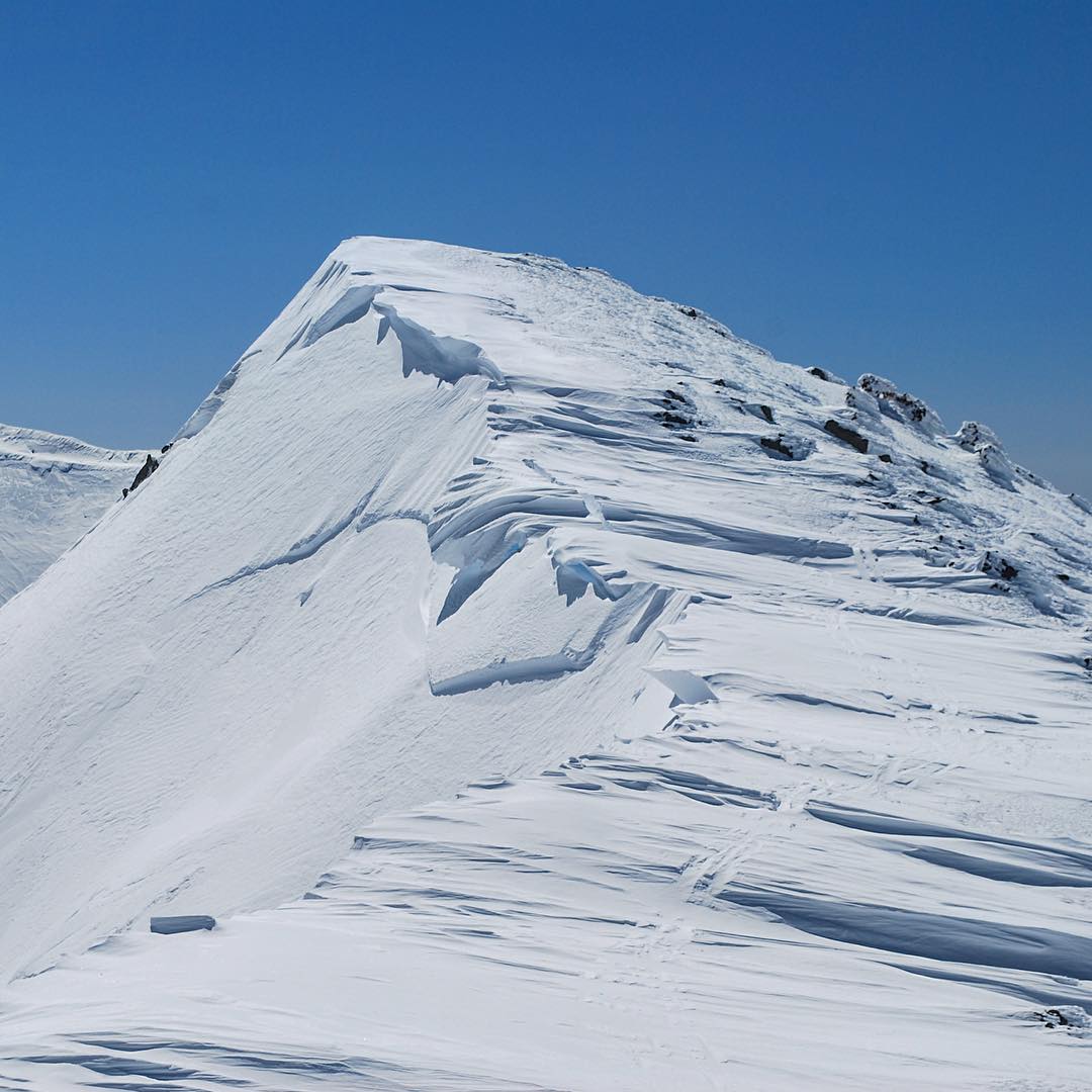
Cornices and crownlines on Rustler Peak. March 2, 2017 photo by Carlos Danel.
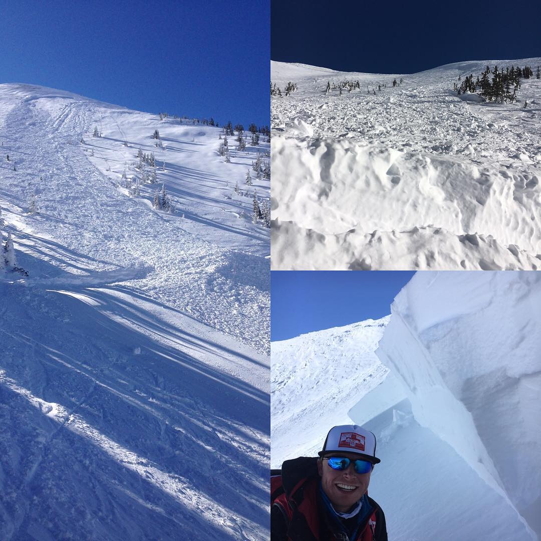
On March 1st Arizona Snowbowl Ski Patrol triggered a slab avalanche in upper bowl. Thes area was closed to the public during avalanche mitigation work. Read more in overall. Photo by Jon Miller.
Final Thoughts
Travelers are advised to exercise caution, make slope specific evaluations and most of all, know where you are going and be prepared for the unexpected.
As always, please treat this summary with appropriately guarded skepticism, make your own assessments, and contribute to our body of knowledge by reporting your observations.
Arizona Snowbowl uphill policy.
Want to learn more safe backcountry habits? KPAC offers level I and II avalanche courses. There is one class left this season.
During winter, backcountry permits are required to access the Kachina Peaks Wilderness. More info
Weather
Strong winds blew and 20-30 inches of snow, with 2-3+ inches of snow water equivalent (SWE) accumulated during the February 27/28 storm.
A short lived warming trend develops on Friday and Saturday. Windy conditions will develop Sunday ahead of a cold front. The cold front will move through northern Arizona from Sunday night into Monday, with light precipitation amounts possible. Monday will be on the cool side, about 5 or so degrees below average. From then on, expect warming temperatures the rest of the week as a strong ridge builds off the west coast. By Friday of next week, temperatures will be in the neighborhood of 10 degrees above average.
On Thursday evening, March 2nd the Inner Basin SNOTEL site (Snowslide) reported a snow depth of 92 inches (234 cm) at 9700’, and Arizona Snowbowl reported 109 inches (277 cm) at 10800'. Since February 17th SNOTEL temperatures ranged between 2° and 40° F and Agassiz station between 0° and 38° F.
Authored/Edited By: Derik Spice, David Lovejoy, Troy Marino
Avalanche Problems/Characters
The avalanche problem/character describes part of the current avalanche danger. However because we only realease a summary once a week, the current avalanche problem will likely change.
Understanding avalanche problems is essential, because it allows you to determine your approach and strategies to risk treatment. Below are brief descriptions of avalanche problems/characters, and links to detailed information on the problem, formation, patterns, recognition, and avoidance strategies.
Avalanche Problems Explained
Also see the North American Danger Scale.
Loose Dry

Release of dry unconsolidated snow. These avalanches typically occur within layers of soft snow near the surface of the snowpack. Loose-dry avalanches start at a point and entrain snow as they move downhill, forming a fan-shaped avalanche. Other names for loose-dry avalanches include point-release avalanches or sluffs. Loose-dry avalanches can trigger slab avalanches that break into deeper snow layers.
Loose Dry avalanches are usually relatively harmless to people. They can be hazardous if you are caught and carried into or over a terrain trap (e.g. gully, rocks, dense timber, cliff, crevasse) or down a long slope. Avoid traveling in or above terrain traps when Loose Dry avalanches are likely. more info
Storm Slab

Release of a soft cohesive layer (a slab) of new snow that breaks within the storm snow or on the old snow surface. Storm-slab problems typically last between a few hours and few days. Storm-slabs that form over a persistent weak layer (surface hoar, depth hoar, or near-surface facets) may be termed Persistent Slabs or may develop into Persistent Slabs.
You can reduce your risk from Storm Slabs by waiting a day or two after a storm before venturing into steep terrain. Storm slabs are most dangerous on slopes with terrain traps, such as timber, gullies, over cliffs, or terrain features that make it difficult for a rider to escape off the side. more info
Wind Slab
Release of a cohesive layer of snow (a slab) formed by the wind. Wind typically transports snow from the upwind sides of terrain features and deposits snow on the downwind side. Wind slabs are often smooth and rounded and sometimes sound hollow, and can range from soft to hard. Wind slabs that form over a persistent weak layer (surface hoar, depth hoar, or near-surface facets) may be termed Persistent Slabs or may develop into Persistent Slabs.
Wind Slabs form in specific areas, and are confined to lee and cross-loaded terrain features. They can be avoided by sticking to sheltered or wind-scoured areas. more info
Persistent Slab
Release of a cohesive layer of soft to hard snow (a slab) in the middle to upper snowpack, when the bond to an underlying persistent weak layer breaks. Persistent layers include: surface hoar, depth hoar, near-surface facets, or faceted snow. Persistent weak layers can continue to produce avalanches for days, weeks or even months, making them especially dangerous and tricky. As additional snow and wind events build a thicker slab on top of the persistent weak layer, this avalanche problem may develop into a Deep Persistent Slab.
The best ways to manage the risk from Persistent Slabs is to make conservative terrain choices. They can be triggered by light loads and weeks after the last storm. The slabs often propagate in surprising and unpredictable ways. This makes this problem difficult to predict and manage and requires a wide safety buffer to handle the uncertainty. more info
Deep Persistent Slab

Release of a thick cohesive layer of hard snow (a slab), when the bond breaks between the slab and an underlying persistent weak layer, deep in the snowpack or near the ground. The most common persistent weak layers involved in deep, persistent slabs are depth hoar or facets surrounding a deeply buried crust. Deep Persistent Slabs are typically hard to trigger, are very destructive and dangerous due to the large mass of snow involved, and can persist for months once developed. They are often triggered from areas where the snow is shallow and weak, and are particularly difficult to forecast for and manage. They commonly develop when Persistent Slabs become more deeply buried over time.
Deep Persistent Slabs are destructive and deadly events that can take months to stabilize. You can trigger them from well down in the avalanche path, and after dozens of tracks have crossed the slope. more info
Loose Wet

Release of wet unconsolidated snow or slush. These avalanches typically occur within layers of wet snow near the surface of the snowpack, but they may quickly gouge into lower snowpack layers. Like Loose Dry Avalanches, they start at a point and entrain snow as they move downhill, forming a fan-shaped avalanche. They generally move slowly, but can contain enough mass to cause significant damage to trees, cars or buildings. Other names for loose-wet avalanches include point-release avalanches or sluffs. Loose Wet avalanches can trigger slab avalanches that break into deeper snow layers.
Travel when the snow surface is colder and stronger. Plan your trips to avoid crossing on or under very steep slopes in the afternoon. Move to colder, shadier slopes once the snow surface turns slushly. Avoid steep, sunlit slopes above terrain traps, cliffs areas and long sustained steep pitches. more info
Wet Slab
Release of a cohesive layer of snow (a slab) that is generally moist or wet when the flow of liquid water weakens the bond between the slab and the surface below (snow or ground). They often occur during prolonged warming events and/or rain-on-snow events. Wet Slabs can be very destructive.
Avoid terrain where and when you suspect Wet Slab avalanche activity. Give yourself a wide safety buffer to handle the uncertainty. more info
Cornice Fall

Cornice Fall is the release of an overhanging mass of snow that forms as the wind moves snow over a sharp terrain feature, such as a ridge, and deposits snow on the downwind (leeward) side. Cornices range in size from small wind lips of soft snow to large overhangs of hard snow that are 30 feet (10 meters) or taller. They can break off the terrain suddenly and pull back onto the ridge top and catch people by surprise even on the flat ground above the slope. Even small cornices can have enough mass to be destructive and deadly. Cornice Fall can entrain loose surface snow or trigger slab avalanches.
Cornices can never be trusted and avoiding them is necessary for safe backcountry travel. Stay well back from ridge line areas with cornices. They often overhang the ridge edge can be triggered remotely. Avoid areas underneath cornices. Even small Cornice Fall can trigger a larger avalanche and large Cornice Fall can easily crush a human. Periods of significant temperature warm-up are times to be particularly aware.
Large cornices are generally rare in Arizona, but they have been observed during very snowy winters. more info
Glide

Release of the entire snow cover as a result of gliding over the ground. Glide avalanches can be composed of wet, moist, or almost entirely dry snow. They typically occur in very specific paths, where the slope is steep enough and the ground surface is relatively smooth. The are often proceeded by full depth cracks (glide cracks), though the time between the appearance of a crack and an avalanche can vary between seconds and months. Glide avalanches are unlikely to be triggered by a person, are nearly impossible to forecast, and thus pose a hazard that is extremely difficult to manage.
Predicting the release of Glide Avalanches is very challenging. Because Glide Avalanches only occur on very specific slopes, safe travel relies on identifying and avoiding those slopes. Glide cracks are a significant indicator, as are recent Glide Avalanches.
Glide avalanches are very uncommon in Arizona. more info