Snowpack Summary for Saturday, December 1, 2018 1:59 PM Winter has arrived on the San Francisco Peaks
This summary expired Dec. 03, 2018 1:59 PM
Flagstaff, Arizona - Backcountry of The San Francisco Peaks and Kachina Peaks Wilderness
The sequence of two storms this weekend is predicted to deposit 12-24 inches of new snow, with southwest winds loading northwest and east aspects. If precipitation and winds meet or exceed predicted levels, natural avalanches will be possible, and skier triggered avalanches are likely on steep terrain where old snow underlies the new. Stability will deteriorate as the second storm impacts the area Saturday. Size and distribution of avalanches will be highly variable based on the distribution of old faceted snow, and the depth and cohesiveness of the new snow on top.
Starting zones will generally be at and above treeline on cool north facing slopes where storm winds have loaded new snow on top of old facets. Potential avalanche sizes will be dependent on new snow depth and wind re-distribution. Moderate to large avalanches may be possible where faceted snow remains in the starting zones, such as Abineau Canyon and North Core Ridge. Expect early season obstacles and hazards in the thin snowpack...
Current Problems (noninclusive) more info


Images
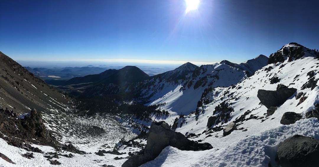
Coverage (remaining from October snow) in Humphrey's Cirque on November 10th, 2018.
Photo by Clay Callaway
Final Thoughts
Backcountry Permits are required for travel in the Kachina Peaks Wilderness and available at local USFS locations, as well as the Agassiz Lodge on Saturday and Sundays 9 -12 a.m. after the Agassiz Chairlift opens in December.
Uphill travel on terrain within the Arizona Snowbowl ski area is still closed. Please refer to flagstaffuphill.com and snowbowl.ski for details.
FREE AVALANCHE AWARENESS SEMINAR: Wednesday December 5, 6:00 pm, 911 Sawmill Rd, Leaf Auditorium.
Weather
Our false start of winter in early October was followed by a month and a half of drought. Most of the 12 to 20 inches of snow that blanketed the Peaks above 10,800 feet has disappeared. The exceptions are up high (above 11,000 feet) and on shady north and northwest aspects where shallow snow remains. This snow has reacted to cold, clear conditions progressively turning to poorly bonded facets.
Now it appears the pattern may be changing and perhaps winter has finally arrived for real. A significant low pressure system is currently bearing down on us (at the time of publication) bringing anticipated snowfall to the high country above 5500-6000 feet. Snow totals are expected to reach between 12 and 20 inches at 10,800 feet. Storm winds will be out of the southwest and west 29-34 mph, gusting to as high as 49 mph; the perfect velocities for moving snow and loading up leeward aspects. A second storm on Saturday and Sunday will be colder and less moist. Snowline is expected to drop to approximately 4,000 feet adding another 6-12 inches of new snow at high elevations. Cold air will follow the second storm’s exit with gradually warming conditions during the week. A third storm appears to be on the distant horizon. It is too early for any certainty on precise timing of impact, but possibly arriving by the end of next week.
On the afternoon of November 30th, the Inner Basin SNOTEL site Snowslide reported a snow depth of 9 inches (23 cm) at 9,730 feet, and Arizona Snowbowl reported a settled base of 14 inches (36 cm) at 10,800 feet. So far this winter, 23 inches (58 cm) of snow have fallen at the mid-mountain study site. Since November 23rd, SNOTEL temperatures have ranged between 47° F on November 27 and 15° F on November 25th. For the same period, the AZ Snowbowl Top Patrol Station (ASBTP, 11,555 feet) the temperature ranged between 38° F on November 27 and 15° F on November 23rd.
Authored/Edited By: David Lovejoy, Troy Marino, Derik Spice
Avalanche Problems/Characters
The avalanche problem/character describes part of the current avalanche danger. However because we only realease a summary once a week, the current avalanche problem will likely change.
Understanding avalanche problems is essential, because it allows you to determine your approach and strategies to risk treatment. Below are brief descriptions of avalanche problems/characters, and links to detailed information on the problem, formation, patterns, recognition, and avoidance strategies.
Avalanche Problems Explained
Also see the North American Danger Scale.
Loose Dry

Release of dry unconsolidated snow. These avalanches typically occur within layers of soft snow near the surface of the snowpack. Loose-dry avalanches start at a point and entrain snow as they move downhill, forming a fan-shaped avalanche. Other names for loose-dry avalanches include point-release avalanches or sluffs. Loose-dry avalanches can trigger slab avalanches that break into deeper snow layers.
Loose Dry avalanches are usually relatively harmless to people. They can be hazardous if you are caught and carried into or over a terrain trap (e.g. gully, rocks, dense timber, cliff, crevasse) or down a long slope. Avoid traveling in or above terrain traps when Loose Dry avalanches are likely. more info
Storm Slab
Release of a soft cohesive layer (a slab) of new snow that breaks within the storm snow or on the old snow surface. Storm-slab problems typically last between a few hours and few days. Storm-slabs that form over a persistent weak layer (surface hoar, depth hoar, or near-surface facets) may be termed Persistent Slabs or may develop into Persistent Slabs.
You can reduce your risk from Storm Slabs by waiting a day or two after a storm before venturing into steep terrain. Storm slabs are most dangerous on slopes with terrain traps, such as timber, gullies, over cliffs, or terrain features that make it difficult for a rider to escape off the side. more info
Wind Slab
Release of a cohesive layer of snow (a slab) formed by the wind. Wind typically transports snow from the upwind sides of terrain features and deposits snow on the downwind side. Wind slabs are often smooth and rounded and sometimes sound hollow, and can range from soft to hard. Wind slabs that form over a persistent weak layer (surface hoar, depth hoar, or near-surface facets) may be termed Persistent Slabs or may develop into Persistent Slabs.
Wind Slabs form in specific areas, and are confined to lee and cross-loaded terrain features. They can be avoided by sticking to sheltered or wind-scoured areas. more info
Persistent Slab
Release of a cohesive layer of soft to hard snow (a slab) in the middle to upper snowpack, when the bond to an underlying persistent weak layer breaks. Persistent layers include: surface hoar, depth hoar, near-surface facets, or faceted snow. Persistent weak layers can continue to produce avalanches for days, weeks or even months, making them especially dangerous and tricky. As additional snow and wind events build a thicker slab on top of the persistent weak layer, this avalanche problem may develop into a Deep Persistent Slab.
The best ways to manage the risk from Persistent Slabs is to make conservative terrain choices. They can be triggered by light loads and weeks after the last storm. The slabs often propagate in surprising and unpredictable ways. This makes this problem difficult to predict and manage and requires a wide safety buffer to handle the uncertainty. more info
Deep Persistent Slab

Release of a thick cohesive layer of hard snow (a slab), when the bond breaks between the slab and an underlying persistent weak layer, deep in the snowpack or near the ground. The most common persistent weak layers involved in deep, persistent slabs are depth hoar or facets surrounding a deeply buried crust. Deep Persistent Slabs are typically hard to trigger, are very destructive and dangerous due to the large mass of snow involved, and can persist for months once developed. They are often triggered from areas where the snow is shallow and weak, and are particularly difficult to forecast for and manage. They commonly develop when Persistent Slabs become more deeply buried over time.
Deep Persistent Slabs are destructive and deadly events that can take months to stabilize. You can trigger them from well down in the avalanche path, and after dozens of tracks have crossed the slope. more info
Loose Wet

Release of wet unconsolidated snow or slush. These avalanches typically occur within layers of wet snow near the surface of the snowpack, but they may quickly gouge into lower snowpack layers. Like Loose Dry Avalanches, they start at a point and entrain snow as they move downhill, forming a fan-shaped avalanche. They generally move slowly, but can contain enough mass to cause significant damage to trees, cars or buildings. Other names for loose-wet avalanches include point-release avalanches or sluffs. Loose Wet avalanches can trigger slab avalanches that break into deeper snow layers.
Travel when the snow surface is colder and stronger. Plan your trips to avoid crossing on or under very steep slopes in the afternoon. Move to colder, shadier slopes once the snow surface turns slushly. Avoid steep, sunlit slopes above terrain traps, cliffs areas and long sustained steep pitches. more info
Wet Slab

Release of a cohesive layer of snow (a slab) that is generally moist or wet when the flow of liquid water weakens the bond between the slab and the surface below (snow or ground). They often occur during prolonged warming events and/or rain-on-snow events. Wet Slabs can be very destructive.
Avoid terrain where and when you suspect Wet Slab avalanche activity. Give yourself a wide safety buffer to handle the uncertainty. more info
Cornice Fall

Cornice Fall is the release of an overhanging mass of snow that forms as the wind moves snow over a sharp terrain feature, such as a ridge, and deposits snow on the downwind (leeward) side. Cornices range in size from small wind lips of soft snow to large overhangs of hard snow that are 30 feet (10 meters) or taller. They can break off the terrain suddenly and pull back onto the ridge top and catch people by surprise even on the flat ground above the slope. Even small cornices can have enough mass to be destructive and deadly. Cornice Fall can entrain loose surface snow or trigger slab avalanches.
Cornices can never be trusted and avoiding them is necessary for safe backcountry travel. Stay well back from ridge line areas with cornices. They often overhang the ridge edge can be triggered remotely. Avoid areas underneath cornices. Even small Cornice Fall can trigger a larger avalanche and large Cornice Fall can easily crush a human. Periods of significant temperature warm-up are times to be particularly aware.
Large cornices are generally rare in Arizona, but they have been observed during very snowy winters. more info
Glide

Release of the entire snow cover as a result of gliding over the ground. Glide avalanches can be composed of wet, moist, or almost entirely dry snow. They typically occur in very specific paths, where the slope is steep enough and the ground surface is relatively smooth. The are often proceeded by full depth cracks (glide cracks), though the time between the appearance of a crack and an avalanche can vary between seconds and months. Glide avalanches are unlikely to be triggered by a person, are nearly impossible to forecast, and thus pose a hazard that is extremely difficult to manage.
Predicting the release of Glide Avalanches is very challenging. Because Glide Avalanches only occur on very specific slopes, safe travel relies on identifying and avoiding those slopes. Glide cracks are a significant indicator, as are recent Glide Avalanches.
Glide avalanches are very uncommon in Arizona. more info
