Snowpack Summary for Friday, December 28, 2018 1:10 PM Winter Weather Advisory. Happy New Year!
This summary expired Dec. 30, 2018 1:10 PM
Flagstaff, Arizona - Backcountry of The San Francisco Peaks and Kachina Peaks Wilderness
High temperatures and strong winds last week created surface crust and wind slabs near ridgetops, at and above treeline on east, west and wind loaded aspects from 70 + mph north winds. The snowpack is thin, @ 60-80 cm in sheltered locations at treeline (@ 11,500'), and thus a temperature gradient exists within the snowpack forming depth hoar and near surface facets, which weaken the structure of the overall snowpack.
Observations from 12-27 indicate poor structure, moderate strength and low reactivity (see attached snow profile). However, near surface facets under these crusts and wind slab may prove to be a dangerous persistent weak layer with significant snowfall. Human triggered avalanches are possible, and natural avalanches are unlikely.
Early season conditions continue. The new snow has marginally improved touring, however coverage will remain spotty with hidden obstacles, especially on sun affected slopes. Over the weekend, ridgeline windchill values will dip to near -15° F.
No natural or skier triggered slab avalanches have been reported so far this winter.
Steep isolated slopes near treeline have localized wind slabs from strong north wind last week. Current ASBTP winds indicate that new wind slabs may be a low probability. The new precipitation is very light and will be easily transported once wind speeds increase.
No significant wind drifts were observed near 10,800' this morning at 8 AM.
With the new snow, decent cross country touring can be found near 9,000' on shady terrain. The snowpack is still thin, watch for hidden obstacles! The overall snowpack depth averages 30" above 10,500', and diminishes rapidly at lower elevations, especially south aspects.
Current Problems (noninclusive) more info

Localized wind slabs from previous wind loading exist on cross loaded slopes and ridgelines at and above treeline. Strength and cohesion of these slabs are variable and may fracture in isolated locations. Hollow sounding snow and whumpfing are indicators of hard slabs and should be avoided. Evaluate each slope before skiing.
Keep an eye on the ASBTP weather station. Speeds between 17 and 25 mph are ideal for transporting snow and creating wind slabs.

The bulls eye slope angle for avalanche activity is 38 degrees. Moderating slope angles to 30 degrees and less drastically reduces the likelihood of triggering an avalanche.
Images
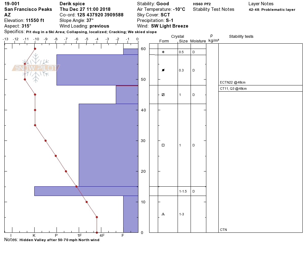
12-27-18 Snow profile from 11,550', Northwest aspect. Note weak near surface facets just below wind slab at 48 cm. These slabs are localized in cross loaded terrain and near ridgelines.
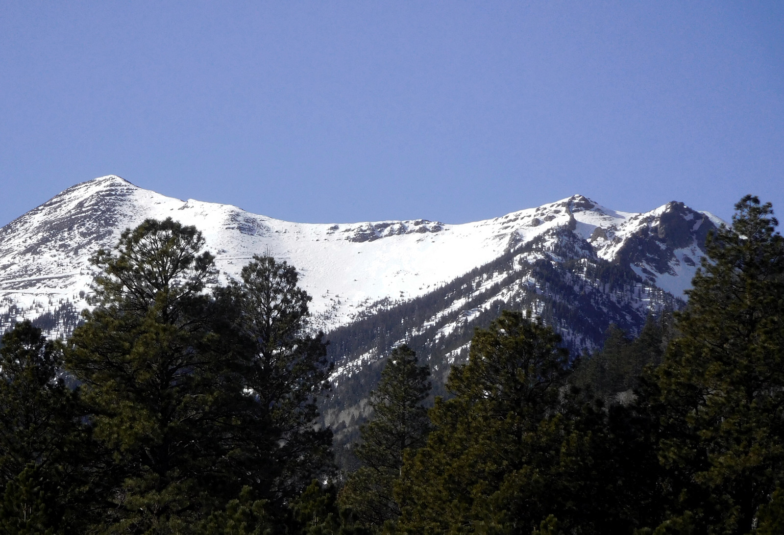
Agassiz Peak and Core Ridge viewed from Lockett Meadow on December 24th, 2018.
Courtesy of Troy Marino.
Final Thoughts
Backcountry permits are required for travel in the Kachina Peaks Wilderness and available at local USFS locations, as well as, at the Agassiz Lodge on Saturday and Sunday 8:30 -11:30 a.m.
For information on uphill travel within the Arizona Snowbowl ski area, please refer to www.flagstaffuphill.com and https://www.snowbowl.ski/the-mountain/uphill-access/ for details. Access to the Kachina Peaks Wilderness is available from the lower lots at Snowbowl via the Humphreys Trail and Kachina Trail.
Weather
By Saturday and Sunday we will feel the coldest temperatures so far this season,
with single digit lows across much of the plateau, and high temperatures likely below freezing.
Flagstaff highs will likely remain near freezing as another weather system looks to impact the area, starting New Years Eve.
On December 20th, Flagstaff hit 62° F. The warmest December temperature in 100 years. The Christmas storm produced only one inch of snow at 10,800'. SnoTel reported less than an inch.
On Friday morning, December 28th, the Inner Basin SNOTEL site (Snowslide) reported a snow depth of 17 inches (43 cm) at 9,730 feet, and Arizona Snowbowl reported a settled base of 33 inches (84 cm) at 10,800 feet. So far this winter, 48 inches (122 cm) of snow have fallen at the mid-mountain study site.
Since December 21st, SNOTEL temperatures have ranged between 6°F on December 27th, and 48°F on December 21st. For the same period, the AZ Snowbowl Top Patrol Station (ASBTP 11,555 feet) temperatures ranged between -1°F on December 28th, and 33°F on December 24th.
Authored/Edited By: David Lovejoy, Troy Marino, Derik Spice
Avalanche Problems/Characters
The avalanche problem/character describes part of the current avalanche danger. However because we only realease a summary once a week, the current avalanche problem will likely change.
Understanding avalanche problems is essential, because it allows you to determine your approach and strategies to risk treatment. Below are brief descriptions of avalanche problems/characters, and links to detailed information on the problem, formation, patterns, recognition, and avoidance strategies.
Avalanche Problems Explained
Also see the North American Danger Scale.
Loose Dry

Release of dry unconsolidated snow. These avalanches typically occur within layers of soft snow near the surface of the snowpack. Loose-dry avalanches start at a point and entrain snow as they move downhill, forming a fan-shaped avalanche. Other names for loose-dry avalanches include point-release avalanches or sluffs. Loose-dry avalanches can trigger slab avalanches that break into deeper snow layers.
Loose Dry avalanches are usually relatively harmless to people. They can be hazardous if you are caught and carried into or over a terrain trap (e.g. gully, rocks, dense timber, cliff, crevasse) or down a long slope. Avoid traveling in or above terrain traps when Loose Dry avalanches are likely. more info
Storm Slab
Release of a soft cohesive layer (a slab) of new snow that breaks within the storm snow or on the old snow surface. Storm-slab problems typically last between a few hours and few days. Storm-slabs that form over a persistent weak layer (surface hoar, depth hoar, or near-surface facets) may be termed Persistent Slabs or may develop into Persistent Slabs.
You can reduce your risk from Storm Slabs by waiting a day or two after a storm before venturing into steep terrain. Storm slabs are most dangerous on slopes with terrain traps, such as timber, gullies, over cliffs, or terrain features that make it difficult for a rider to escape off the side. more info
Wind Slab
Release of a cohesive layer of snow (a slab) formed by the wind. Wind typically transports snow from the upwind sides of terrain features and deposits snow on the downwind side. Wind slabs are often smooth and rounded and sometimes sound hollow, and can range from soft to hard. Wind slabs that form over a persistent weak layer (surface hoar, depth hoar, or near-surface facets) may be termed Persistent Slabs or may develop into Persistent Slabs.
Wind Slabs form in specific areas, and are confined to lee and cross-loaded terrain features. They can be avoided by sticking to sheltered or wind-scoured areas. more info
Persistent Slab

Release of a cohesive layer of soft to hard snow (a slab) in the middle to upper snowpack, when the bond to an underlying persistent weak layer breaks. Persistent layers include: surface hoar, depth hoar, near-surface facets, or faceted snow. Persistent weak layers can continue to produce avalanches for days, weeks or even months, making them especially dangerous and tricky. As additional snow and wind events build a thicker slab on top of the persistent weak layer, this avalanche problem may develop into a Deep Persistent Slab.
The best ways to manage the risk from Persistent Slabs is to make conservative terrain choices. They can be triggered by light loads and weeks after the last storm. The slabs often propagate in surprising and unpredictable ways. This makes this problem difficult to predict and manage and requires a wide safety buffer to handle the uncertainty. more info
Deep Persistent Slab

Release of a thick cohesive layer of hard snow (a slab), when the bond breaks between the slab and an underlying persistent weak layer, deep in the snowpack or near the ground. The most common persistent weak layers involved in deep, persistent slabs are depth hoar or facets surrounding a deeply buried crust. Deep Persistent Slabs are typically hard to trigger, are very destructive and dangerous due to the large mass of snow involved, and can persist for months once developed. They are often triggered from areas where the snow is shallow and weak, and are particularly difficult to forecast for and manage. They commonly develop when Persistent Slabs become more deeply buried over time.
Deep Persistent Slabs are destructive and deadly events that can take months to stabilize. You can trigger them from well down in the avalanche path, and after dozens of tracks have crossed the slope. more info
Loose Wet

Release of wet unconsolidated snow or slush. These avalanches typically occur within layers of wet snow near the surface of the snowpack, but they may quickly gouge into lower snowpack layers. Like Loose Dry Avalanches, they start at a point and entrain snow as they move downhill, forming a fan-shaped avalanche. They generally move slowly, but can contain enough mass to cause significant damage to trees, cars or buildings. Other names for loose-wet avalanches include point-release avalanches or sluffs. Loose Wet avalanches can trigger slab avalanches that break into deeper snow layers.
Travel when the snow surface is colder and stronger. Plan your trips to avoid crossing on or under very steep slopes in the afternoon. Move to colder, shadier slopes once the snow surface turns slushly. Avoid steep, sunlit slopes above terrain traps, cliffs areas and long sustained steep pitches. more info
Wet Slab

Release of a cohesive layer of snow (a slab) that is generally moist or wet when the flow of liquid water weakens the bond between the slab and the surface below (snow or ground). They often occur during prolonged warming events and/or rain-on-snow events. Wet Slabs can be very destructive.
Avoid terrain where and when you suspect Wet Slab avalanche activity. Give yourself a wide safety buffer to handle the uncertainty. more info
Cornice Fall

Cornice Fall is the release of an overhanging mass of snow that forms as the wind moves snow over a sharp terrain feature, such as a ridge, and deposits snow on the downwind (leeward) side. Cornices range in size from small wind lips of soft snow to large overhangs of hard snow that are 30 feet (10 meters) or taller. They can break off the terrain suddenly and pull back onto the ridge top and catch people by surprise even on the flat ground above the slope. Even small cornices can have enough mass to be destructive and deadly. Cornice Fall can entrain loose surface snow or trigger slab avalanches.
Cornices can never be trusted and avoiding them is necessary for safe backcountry travel. Stay well back from ridge line areas with cornices. They often overhang the ridge edge can be triggered remotely. Avoid areas underneath cornices. Even small Cornice Fall can trigger a larger avalanche and large Cornice Fall can easily crush a human. Periods of significant temperature warm-up are times to be particularly aware.
Large cornices are generally rare in Arizona, but they have been observed during very snowy winters. more info
Glide

Release of the entire snow cover as a result of gliding over the ground. Glide avalanches can be composed of wet, moist, or almost entirely dry snow. They typically occur in very specific paths, where the slope is steep enough and the ground surface is relatively smooth. The are often proceeded by full depth cracks (glide cracks), though the time between the appearance of a crack and an avalanche can vary between seconds and months. Glide avalanches are unlikely to be triggered by a person, are nearly impossible to forecast, and thus pose a hazard that is extremely difficult to manage.
Predicting the release of Glide Avalanches is very challenging. Because Glide Avalanches only occur on very specific slopes, safe travel relies on identifying and avoiding those slopes. Glide cracks are a significant indicator, as are recent Glide Avalanches.
Glide avalanches are very uncommon in Arizona. more info
