Snowpack Summary for Friday, December 7, 2018 11:38 AM Winter has arrived on the San Francisco Peaks!
This summary expired Dec. 09, 2018 11:38 AM
Flagstaff, Arizona - Backcountry of The San Francisco Peaks and Kachina Peaks Wilderness
The latest storm, which arrived on Thursday afternoon December 6th, has thus far dropped relatively modest amounts of snow (4-5 inches at 10,800 feet). Lesser amounts were recorded at lower elevations. The snow line is at 7,500 feet. The new load would not be alarming on its own; however, moderate winds out of the southwest have been sufficient to transport new snow creating a potential concern.
On steep wind loaded slopes, skier triggered avalanches are possible. Size and destructive potential of such avalanches will be highly variable. Old faceted snow is hidden at the bottom of the snowpack on north and northeast aspects at high elevations. Smaller, less destructive avalanches may occur due to insufficient time for new wind slab from the most recent storm to bond to the snow below.
Starting zones will generally be near and above treeline on wind loaded slopes and sidewalls of gullies. Wind loaded zones could exist on a variety of aspects, because winds following last week’s storm cycle blew out of the north and east for a period of time. Overall, keep an eye out for snow pillows, indicating snow loading, and slab formation. Whumpfing or cracking of slabs are indicators of instability. Stay clear of these features and moderate slope angle to below 30 degrees.
Early season skiing and riding can be particularly dangerous as overzealous enthusiasm leads to poor decision-making. Give the new snow time to bond to the snowpack below. Also, snow coverage above treeline is highly variable. Hidden rocks and other obstacles may be present. Ski with early-season caution and awareness in order to enjoy the rest of the winter, once coverage improves.
Current Problems (noninclusive) more info

Images
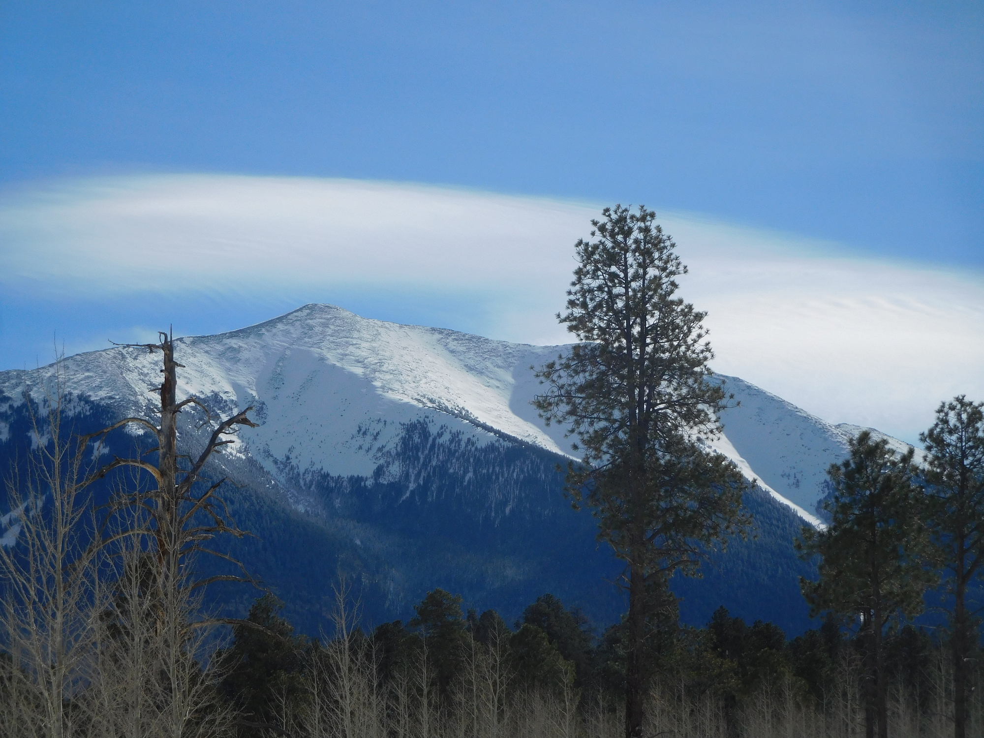
NW side of Humphrey's Peak. From left to right: Lew Canyon, Philomena Springs (Little Sister) Bowl, and Allison Clay Bowl.
Dec. 4th 2018 photo by Troy Marino.
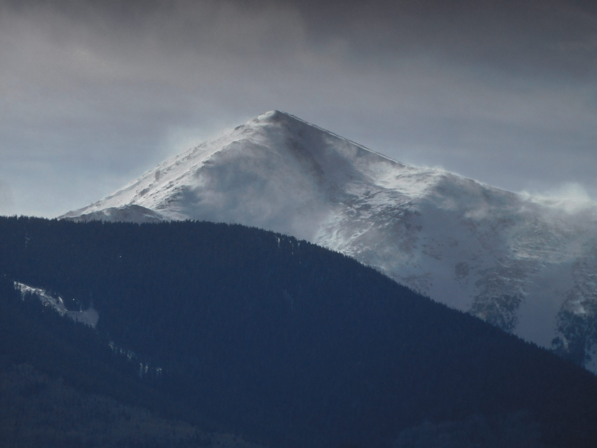
On Dec. 5th. 2018, we observed wind loading of starting zones in the northeasterly avalanche paths of Abineau Canyon.
Photo by Troy Marino.
Final Thoughts
https://www.rei.com/event/avalanche-awareness/flagstaff/226586?cm_mmc=sm_fb_76515-_-flagstaff-_-opo_field-_-event_reg
Backcountry permits are required for travel in the Kachina Peaks Wilderness and available at local USFS locations, as well as, at the Agassiz Lodge on Saturday and Sunday 8:30 -11:30 a.m.
Uphill travel on terrain within the Arizona Snowbowl ski area is still closed. Please refer to www.flagstaffuphill.com and https://www.snowbowl.ski/the-mountain/uphill-access/ for details. Access to the Kachina Peaks Wilderness is available from the lower lots at Snowbowl via the Humphreys Trail and Kachina Trail.
Weather
Over the past 48 hours, winds have been moderate out of the south-southwest, 10-20 mph; gusting to 30 mph. Wind velocities have been abating as the storm progresses. As the sky clears in the storm’s aftermath, cold basin temperatures and inversion fog may be present in Fort Valley and elsewhere on Saturday morning.
The upcoming week will bring generally drying and warming conditions with a chance for more precipitation midweek. At the time of publication, it was still too early to predict the timing, path, and precipitation potential of this approaching event.
On Friday morning December 7th, the Inner Basin SNOTEL site (Snowslide) reported a snow depth of 15 inches (38 cm) at 9,730 feet; and Arizona Snowbowl reported a settled base of 26 inches (66 cm) at 10,800 feet. So far this winter 41 inches (104 cm) of snow have fallen at the mid-mountain study site. Since November 30th, SNOTEL temperatures have ranged between 0°F on December 3rd, and 37°F on December 5th. For the same period, the AZ Snowbowl Top Patrol Station (ASBTP 11,555 feet) temperatures ranged between 2°F on December 3rd and 30°F on December 5th.
Authored/Edited By: Troy Marino, David Lovejoy, Derik Spice
Avalanche Problems/Characters
The avalanche problem/character describes part of the current avalanche danger. However because we only realease a summary once a week, the current avalanche problem will likely change.
Understanding avalanche problems is essential, because it allows you to determine your approach and strategies to risk treatment. Below are brief descriptions of avalanche problems/characters, and links to detailed information on the problem, formation, patterns, recognition, and avoidance strategies.
Avalanche Problems Explained
Also see the North American Danger Scale.
Loose Dry

Release of dry unconsolidated snow. These avalanches typically occur within layers of soft snow near the surface of the snowpack. Loose-dry avalanches start at a point and entrain snow as they move downhill, forming a fan-shaped avalanche. Other names for loose-dry avalanches include point-release avalanches or sluffs. Loose-dry avalanches can trigger slab avalanches that break into deeper snow layers.
Loose Dry avalanches are usually relatively harmless to people. They can be hazardous if you are caught and carried into or over a terrain trap (e.g. gully, rocks, dense timber, cliff, crevasse) or down a long slope. Avoid traveling in or above terrain traps when Loose Dry avalanches are likely. more info
Storm Slab

Release of a soft cohesive layer (a slab) of new snow that breaks within the storm snow or on the old snow surface. Storm-slab problems typically last between a few hours and few days. Storm-slabs that form over a persistent weak layer (surface hoar, depth hoar, or near-surface facets) may be termed Persistent Slabs or may develop into Persistent Slabs.
You can reduce your risk from Storm Slabs by waiting a day or two after a storm before venturing into steep terrain. Storm slabs are most dangerous on slopes with terrain traps, such as timber, gullies, over cliffs, or terrain features that make it difficult for a rider to escape off the side. more info
Wind Slab
Release of a cohesive layer of snow (a slab) formed by the wind. Wind typically transports snow from the upwind sides of terrain features and deposits snow on the downwind side. Wind slabs are often smooth and rounded and sometimes sound hollow, and can range from soft to hard. Wind slabs that form over a persistent weak layer (surface hoar, depth hoar, or near-surface facets) may be termed Persistent Slabs or may develop into Persistent Slabs.
Wind Slabs form in specific areas, and are confined to lee and cross-loaded terrain features. They can be avoided by sticking to sheltered or wind-scoured areas. more info
Persistent Slab

Release of a cohesive layer of soft to hard snow (a slab) in the middle to upper snowpack, when the bond to an underlying persistent weak layer breaks. Persistent layers include: surface hoar, depth hoar, near-surface facets, or faceted snow. Persistent weak layers can continue to produce avalanches for days, weeks or even months, making them especially dangerous and tricky. As additional snow and wind events build a thicker slab on top of the persistent weak layer, this avalanche problem may develop into a Deep Persistent Slab.
The best ways to manage the risk from Persistent Slabs is to make conservative terrain choices. They can be triggered by light loads and weeks after the last storm. The slabs often propagate in surprising and unpredictable ways. This makes this problem difficult to predict and manage and requires a wide safety buffer to handle the uncertainty. more info
Deep Persistent Slab

Release of a thick cohesive layer of hard snow (a slab), when the bond breaks between the slab and an underlying persistent weak layer, deep in the snowpack or near the ground. The most common persistent weak layers involved in deep, persistent slabs are depth hoar or facets surrounding a deeply buried crust. Deep Persistent Slabs are typically hard to trigger, are very destructive and dangerous due to the large mass of snow involved, and can persist for months once developed. They are often triggered from areas where the snow is shallow and weak, and are particularly difficult to forecast for and manage. They commonly develop when Persistent Slabs become more deeply buried over time.
Deep Persistent Slabs are destructive and deadly events that can take months to stabilize. You can trigger them from well down in the avalanche path, and after dozens of tracks have crossed the slope. more info
Loose Wet

Release of wet unconsolidated snow or slush. These avalanches typically occur within layers of wet snow near the surface of the snowpack, but they may quickly gouge into lower snowpack layers. Like Loose Dry Avalanches, they start at a point and entrain snow as they move downhill, forming a fan-shaped avalanche. They generally move slowly, but can contain enough mass to cause significant damage to trees, cars or buildings. Other names for loose-wet avalanches include point-release avalanches or sluffs. Loose Wet avalanches can trigger slab avalanches that break into deeper snow layers.
Travel when the snow surface is colder and stronger. Plan your trips to avoid crossing on or under very steep slopes in the afternoon. Move to colder, shadier slopes once the snow surface turns slushly. Avoid steep, sunlit slopes above terrain traps, cliffs areas and long sustained steep pitches. more info
Wet Slab

Release of a cohesive layer of snow (a slab) that is generally moist or wet when the flow of liquid water weakens the bond between the slab and the surface below (snow or ground). They often occur during prolonged warming events and/or rain-on-snow events. Wet Slabs can be very destructive.
Avoid terrain where and when you suspect Wet Slab avalanche activity. Give yourself a wide safety buffer to handle the uncertainty. more info
Cornice Fall

Cornice Fall is the release of an overhanging mass of snow that forms as the wind moves snow over a sharp terrain feature, such as a ridge, and deposits snow on the downwind (leeward) side. Cornices range in size from small wind lips of soft snow to large overhangs of hard snow that are 30 feet (10 meters) or taller. They can break off the terrain suddenly and pull back onto the ridge top and catch people by surprise even on the flat ground above the slope. Even small cornices can have enough mass to be destructive and deadly. Cornice Fall can entrain loose surface snow or trigger slab avalanches.
Cornices can never be trusted and avoiding them is necessary for safe backcountry travel. Stay well back from ridge line areas with cornices. They often overhang the ridge edge can be triggered remotely. Avoid areas underneath cornices. Even small Cornice Fall can trigger a larger avalanche and large Cornice Fall can easily crush a human. Periods of significant temperature warm-up are times to be particularly aware.
Large cornices are generally rare in Arizona, but they have been observed during very snowy winters. more info
Glide

Release of the entire snow cover as a result of gliding over the ground. Glide avalanches can be composed of wet, moist, or almost entirely dry snow. They typically occur in very specific paths, where the slope is steep enough and the ground surface is relatively smooth. The are often proceeded by full depth cracks (glide cracks), though the time between the appearance of a crack and an avalanche can vary between seconds and months. Glide avalanches are unlikely to be triggered by a person, are nearly impossible to forecast, and thus pose a hazard that is extremely difficult to manage.
Predicting the release of Glide Avalanches is very challenging. Because Glide Avalanches only occur on very specific slopes, safe travel relies on identifying and avoiding those slopes. Glide cracks are a significant indicator, as are recent Glide Avalanches.
Glide avalanches are very uncommon in Arizona. more info
