Snowpack Summary for Friday, February 23, 2018 3:02 PM 11" of new snow this week! Level 1 Avalanche Course next weekend...
This summary expired Feb. 25, 2018 3:02 PM
Flagstaff, Arizona - Backcountry of The San Francisco Peaks and Kachina Peaks Wilderness
Overall
Winter conditions have returned to the Peaks with new snowfall, cold temperatures, and significant wind transport.
With new snow the ability to access backcountry skiing/snowboarding has improved. However, getting to and from good coverage may involve hiking over rocks and logs.
Avalanches may be possible near and above treeline where wind slabs have developed with continued wind transport from the south (S) and southwest (SW). Observations from the past week in Inner Basin Bowl and on Fremont Peak indicated continued wind slab deposits in Northerly aspects, increasing load on existing weak layers.
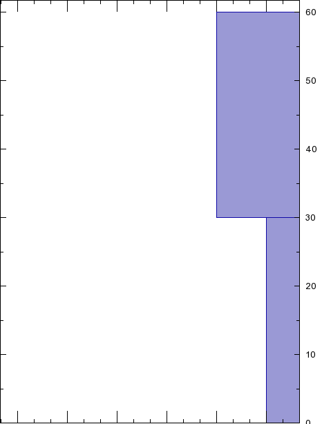
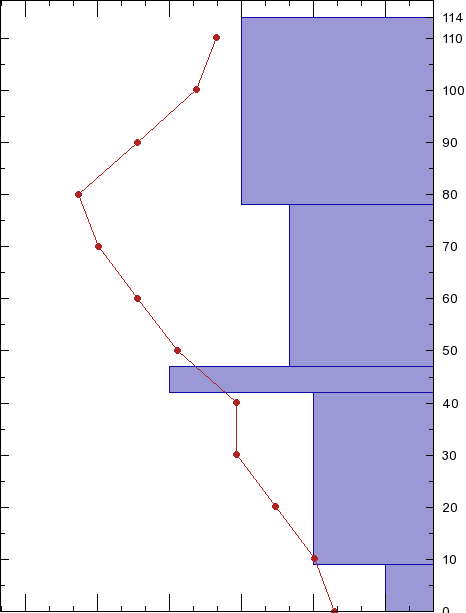
In addition to further wind slab creation, the presence of basal faceting has been observed on generally N facing aspects from ground level up to 30 cm (See attached snow pit diagrams), and has demonstrated failure and propagation on these facets, though spatially variable.
Cold temperatures and a relatively shallow snow pack may continue to build weak facet layers at ground level, below wind slabs and new storm snow accumulation. All of these factors could lead to heightened avalanche activity, especially on Northerly aspects and starting zones with recent wind loading and a bed surface.
Currently, year to date snowfall is at 55" (137 cm) at 10,800', with a settled base depth of about 33" (82 cm) on a sheltered NW aspect. 9,500' base depth is @ 17" (43 cm).
Near and Above TreelineAbove treeline snow has loaded leeward North facing slopes near ridge lines creating wind slabs that have demonstrated varying levels of stability. On Saturday and Sunday earlier this week, prior to the new storm systems, consistent SW winds were observed depositing smaller grains and forming harder wind slabs on weaker lower layers throughout the Inner Basin area on N- NW and NE aspects.
With similar conditions continuing, a greater likelihood of human triggered wind slabs exists.
With similar conditions continuing, a greater likelihood of human triggered wind slabs exists.
Below TreelineWith ~33" (83 cm) undisturbed settled snow depth at 10,800', NW aspect, coverage is improving but insufficient to cover many obstacles. Rocks and logs remain primary hazards. Most northerly aspects will have the best coverage with measured depths above 10,000 ft ranging from 20" - 48" (50 cm to 120 cm), while south facing slopes range from limited coverage to 28" (70 cm) in favored locations near treeline. Variable melt freeze crusts exist in the south facing snowpack.
Watch out for small isolated slabs of new snow, wind deposits and storm accumulation perched on older layers.
Watch out for small isolated slabs of new snow, wind deposits and storm accumulation perched on older layers.
Current Problems (noninclusive) more info

Watch out for wind slabs and/or wind loading on northwesterly, northerly, northeasterly and easterly slopes.
With a forecast of increased snow accumulation accompanied by moderate to strong winds wind slab creation will pose the greatest concern to back country travelers.
Although observations have found spatially specific wind slab locations, be cautious of more widespread wind deposition with wind directions forecasted to change and then return to SW predominance by Monday.

With accumulation of new snow onto existing bed surfaces, areas of instability may be present on all aspects. Be cautious of previously loaded terrain with slope angles exceeding 30 degrees, and runout zones which may hold more snow than starting zones.
Also, note that many south facing and wind scoured slopes may not have had coverage previous to this current storm cycle, thus use caution.
Also, note that many south facing and wind scoured slopes may not have had coverage previous to this current storm cycle, thus use caution.
Images
Final Thoughts
Remember that Backcountry Permits are required for travel in the Kachina Peaks Wilderness and available at local USFS locations, as well as at the Agassiz Lodge on Saturday and Sunday until 11 a.m.
"Currently, uphill travel on terrain within the Arizona Snowbowl ski area is unavailable due to mountain operations and construction projects."
https://www.snowbowl.ski/the-mountain/uphill-access/
KPAC is offering the first Level 1 Avalanche Course of the season next weekend, March 2-4. Please join us for the foundation course of your backcountry future.
Weather
Last updated on Friday, February 23, 2018
Oh what difference a week can make. Winter seems to have arrived in northern Arizona with a week of windy, cold weather and encouraging accumulations of snow. After the President’s Day storm, Arizona Snowbowl reported 8 inches of new snow at 10,800’ (since our last summary) with an additional 5 inches last night. Total YTD snowfall is 55".
High winds forced resort closure on President’s Day and resulted in significant snow movement, characterized by stripping from SW windward aspects. A post storm arctic blast delivered the lowest temperatures so far this season with below freezing highs and sub zero low temperatures (F) recorded at the Snowslide SNOTEL site (9730’). The new Arizona Snowbowl Top Patrol (ASTP) weather station (11555’) recorded wind gusts to 50 mph on February 19th, although we suspect the anemometer was under reporting. On February 20th, a low temperature of -7° (F) was recorded with 21 mph wind, resulting in a wind chill of -32 (F), nippy indeed.
At the time of publication we are entering another storm pattern fed by cold northern air. This disturbance is forecast to culminate by Saturday evening February 24th and expected to add another 6-10 inches of snow at and above treeline. Looking on down the line, breezy cool conditions will continue with another storm impacting the region early in the workweek. More snow is expected starting on Tuesday February 27th.
On Friday February 23rd the Inner Basin SNOTEL site (Snowslide) reported a snow depth of 23 inches (58.5 cm) at 9730’, and Arizona Snowbowl reported a settled base of 33 inches (84 cm) at 10800'. So far this winter, 55 inches (140 cm) of snow has fallen at the mid-mountain study site. Since February 16th, SNOTEL temperatures ranged between -1° and 43° F. For the same period the AZ Snowbowl Top Patrol Station (ASTP) temperatures ranged between -7° and 39° F.
Agassiz Peak Station 11500'
Snowslide Canyon Snotel (Inner Basin) 9730′
Authored/Edited By: Derik Spice
