Snowpack Summary for Friday, March 2, 2018 6:49 PM 45" (114 cm) of snowfall for February!
This summary expired Mar. 04, 2018 6:49 PM
Flagstaff, Arizona - Backcountry of The San Francisco Peaks and Kachina Peaks Wilderness
Thin coverage and rock/log hits are likely.
Natural avalanches are unlikely, but human triggered avalanches are possible, with increasing likelihood of moderate severity with added weight from wind transport and or precipitation. The weak basal facet structure of the snowpack has shown low strength and moderate to high propagation reactivity.
Currently, year to date snowfall is at 75" (190 cm) at 10,800', with a settled base depth of about 37" (94 cm) on a sheltered NW aspect. 9,500' base depth is @ 22" (56 cm).
Avalanches may be possible near and above treeline where wind slabs have developed with continued wind transport from the south (S) and southwest (SW), as well as strong north (N) winds 2-25-18, though some starting zones are more rocks than snow, especially on south aspects. Observations from the past week in the Inner Basin indicated continued wind slab deposits on a variety of aspects along ridge lines, as well as cross loading at lower elevations, increasing load on existing weak layers.
Basal faceting has been observed on generally N facing aspects near treeline, from ground level up to 30 cm (See snow pit diagrams under the 'Snowpack' tab), and has demonstrated failure and propagation on these facets, though spatially variable.
View snow pits at snowpilot.org.
With similar conditions continuing, a greater likelihood of human triggered wind slabs exists, either in thin starting zones or cross loaded areas below ridge lines.
Watch out for small isolated slabs of new snow, wind deposits and storm accumulation perched on older layers.
Also, the snow depth is highly variable due to wind transport and sun affect, aspect dependent.
Current Problems (noninclusive) more info

With a forecast of possible new snow accumulation accompanied by moderate to strong winds, wind slab creation may increase potential hazard.

Images
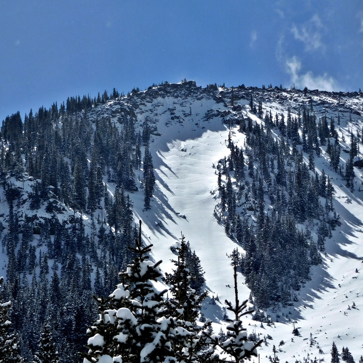
Wind slabs and wind loading at the top of Jay's Slide avalanche path, just below treeline on the northerly slopes of Fremont Peak. February 28, 2018.
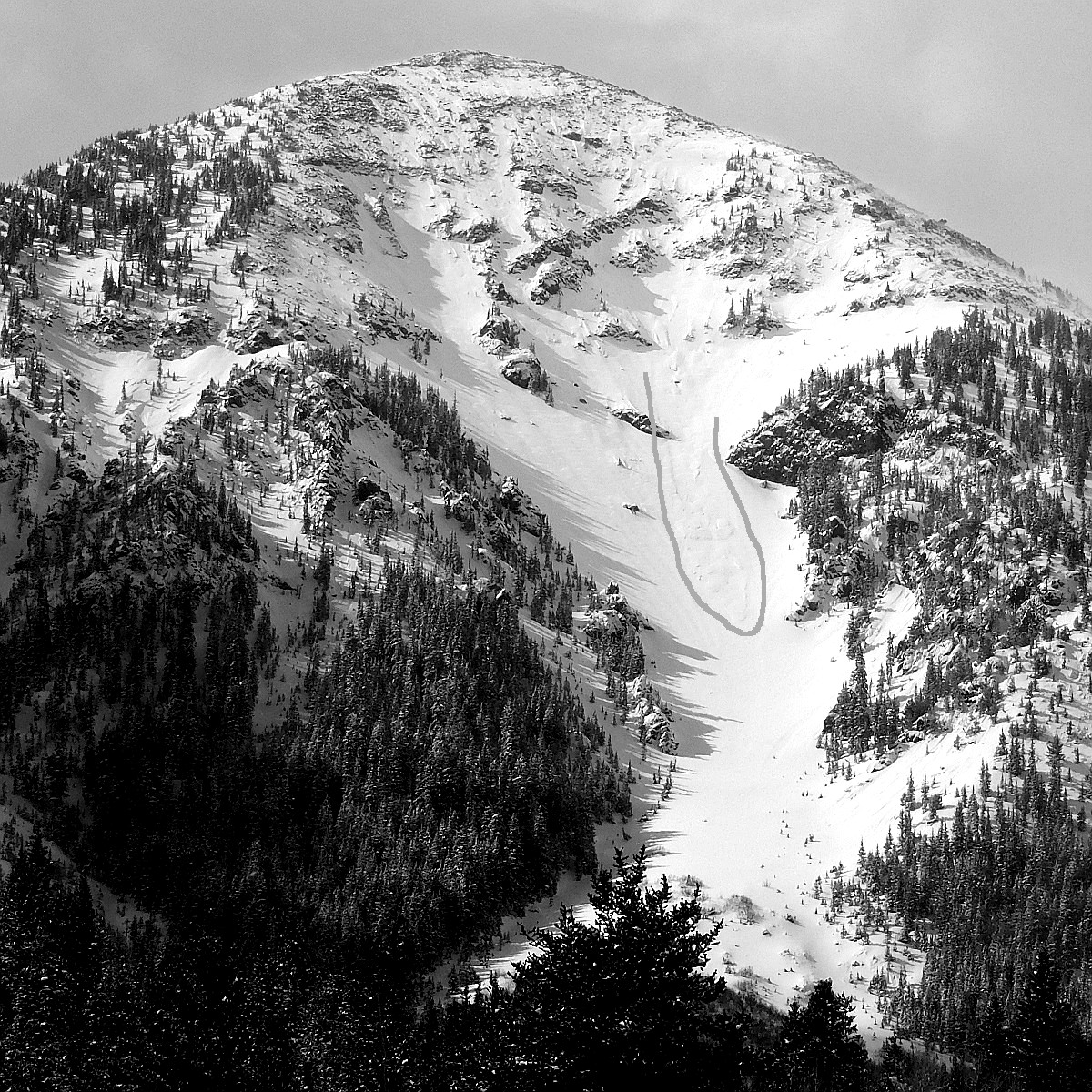
Small storm-snow sluff in Telemark avalanche path, northerly slopes of Fremont Peak. Occurred during the early morning hours of the February 28th storm. Image traced to show sluff.
Final Thoughts
"Uphill travel on terrain within the Arizona Snowbowl ski area is currently unavailable due to mountain operations and construction projects."
https://www.snowbowl.ski/the-mountain/uphill-access/
Weather
Northern Arizona continues to occupy a favorable position within the western storm track, however a bit south of the core energy. Last weekend’s storm produced almost a foot of cold low density snow at treeline. On Tuesday night and Wednesday February 28th another foot plus was laid down at 10,800’. This storm also produced low density cold dendrites (stellar crystals) and was easily moved by moderate storm winds and stronger and gusty winds shifting to north and northwest as the storm passed. Above treeline snow stripping, sublimation, and some slab deposition is evident.
On the horizon, set to enter our region on Saturday night March 3th, one more storm, however this time most of the fireworks appear to be to our north and we are expecting strong winds but little snow accumulation. A warming trend and gusty winds will characterize the upcoming work week.
On Thursday evening, March 1st the Inner Basin SNOTEL site (Snowslide) reported a snow depth of 26 inches (66 cm) at 9730’, and Arizona Snowbowl reported a settled base of 41 inches (104 cm) at 10800'. So far this winter, 75 inches (190.5 cm) of snow has fallen at the mid-mountain study site. Since February 23rd, SNOTEL temperatures ranged between 3° and 40° F. For the same period the AZ Snowbowl Top Patrol Station (ASTP) temperatures ranged between –0.5° and 2 9° F.
Agassiz Peak Station 11500'
Snowslide Canyon Snotel (Inner Basin) 9730′
Authored/Edited By: Troy Marino, Derik Spice
Avalanche Problems/Characters
The avalanche problem/character describes part of the current avalanche danger. However because we only realease a summary once a week, the current avalanche problem will likely change.
Understanding avalanche problems is essential, because it allows you to determine your approach and strategies to risk treatment. Below are brief descriptions of avalanche problems/characters, and links to detailed information on the problem, formation, patterns, recognition, and avoidance strategies.
Avalanche Problems Explained
Also see the North American Danger Scale.
Loose Dry

Release of dry unconsolidated snow. These avalanches typically occur within layers of soft snow near the surface of the snowpack. Loose-dry avalanches start at a point and entrain snow as they move downhill, forming a fan-shaped avalanche. Other names for loose-dry avalanches include point-release avalanches or sluffs. Loose-dry avalanches can trigger slab avalanches that break into deeper snow layers.
Loose Dry avalanches are usually relatively harmless to people. They can be hazardous if you are caught and carried into or over a terrain trap (e.g. gully, rocks, dense timber, cliff, crevasse) or down a long slope. Avoid traveling in or above terrain traps when Loose Dry avalanches are likely. more info
Storm Slab

Release of a soft cohesive layer (a slab) of new snow that breaks within the storm snow or on the old snow surface. Storm-slab problems typically last between a few hours and few days. Storm-slabs that form over a persistent weak layer (surface hoar, depth hoar, or near-surface facets) may be termed Persistent Slabs or may develop into Persistent Slabs.
You can reduce your risk from Storm Slabs by waiting a day or two after a storm before venturing into steep terrain. Storm slabs are most dangerous on slopes with terrain traps, such as timber, gullies, over cliffs, or terrain features that make it difficult for a rider to escape off the side. more info
Wind Slab
Release of a cohesive layer of snow (a slab) formed by the wind. Wind typically transports snow from the upwind sides of terrain features and deposits snow on the downwind side. Wind slabs are often smooth and rounded and sometimes sound hollow, and can range from soft to hard. Wind slabs that form over a persistent weak layer (surface hoar, depth hoar, or near-surface facets) may be termed Persistent Slabs or may develop into Persistent Slabs.
Wind Slabs form in specific areas, and are confined to lee and cross-loaded terrain features. They can be avoided by sticking to sheltered or wind-scoured areas. more info
Persistent Slab
Release of a cohesive layer of soft to hard snow (a slab) in the middle to upper snowpack, when the bond to an underlying persistent weak layer breaks. Persistent layers include: surface hoar, depth hoar, near-surface facets, or faceted snow. Persistent weak layers can continue to produce avalanches for days, weeks or even months, making them especially dangerous and tricky. As additional snow and wind events build a thicker slab on top of the persistent weak layer, this avalanche problem may develop into a Deep Persistent Slab.
The best ways to manage the risk from Persistent Slabs is to make conservative terrain choices. They can be triggered by light loads and weeks after the last storm. The slabs often propagate in surprising and unpredictable ways. This makes this problem difficult to predict and manage and requires a wide safety buffer to handle the uncertainty. more info
Deep Persistent Slab

Release of a thick cohesive layer of hard snow (a slab), when the bond breaks between the slab and an underlying persistent weak layer, deep in the snowpack or near the ground. The most common persistent weak layers involved in deep, persistent slabs are depth hoar or facets surrounding a deeply buried crust. Deep Persistent Slabs are typically hard to trigger, are very destructive and dangerous due to the large mass of snow involved, and can persist for months once developed. They are often triggered from areas where the snow is shallow and weak, and are particularly difficult to forecast for and manage. They commonly develop when Persistent Slabs become more deeply buried over time.
Deep Persistent Slabs are destructive and deadly events that can take months to stabilize. You can trigger them from well down in the avalanche path, and after dozens of tracks have crossed the slope. more info
Loose Wet

Release of wet unconsolidated snow or slush. These avalanches typically occur within layers of wet snow near the surface of the snowpack, but they may quickly gouge into lower snowpack layers. Like Loose Dry Avalanches, they start at a point and entrain snow as they move downhill, forming a fan-shaped avalanche. They generally move slowly, but can contain enough mass to cause significant damage to trees, cars or buildings. Other names for loose-wet avalanches include point-release avalanches or sluffs. Loose Wet avalanches can trigger slab avalanches that break into deeper snow layers.
Travel when the snow surface is colder and stronger. Plan your trips to avoid crossing on or under very steep slopes in the afternoon. Move to colder, shadier slopes once the snow surface turns slushly. Avoid steep, sunlit slopes above terrain traps, cliffs areas and long sustained steep pitches. more info
Wet Slab

Release of a cohesive layer of snow (a slab) that is generally moist or wet when the flow of liquid water weakens the bond between the slab and the surface below (snow or ground). They often occur during prolonged warming events and/or rain-on-snow events. Wet Slabs can be very destructive.
Avoid terrain where and when you suspect Wet Slab avalanche activity. Give yourself a wide safety buffer to handle the uncertainty. more info
Cornice Fall

Cornice Fall is the release of an overhanging mass of snow that forms as the wind moves snow over a sharp terrain feature, such as a ridge, and deposits snow on the downwind (leeward) side. Cornices range in size from small wind lips of soft snow to large overhangs of hard snow that are 30 feet (10 meters) or taller. They can break off the terrain suddenly and pull back onto the ridge top and catch people by surprise even on the flat ground above the slope. Even small cornices can have enough mass to be destructive and deadly. Cornice Fall can entrain loose surface snow or trigger slab avalanches.
Cornices can never be trusted and avoiding them is necessary for safe backcountry travel. Stay well back from ridge line areas with cornices. They often overhang the ridge edge can be triggered remotely. Avoid areas underneath cornices. Even small Cornice Fall can trigger a larger avalanche and large Cornice Fall can easily crush a human. Periods of significant temperature warm-up are times to be particularly aware.
Large cornices are generally rare in Arizona, but they have been observed during very snowy winters. more info
Glide

Release of the entire snow cover as a result of gliding over the ground. Glide avalanches can be composed of wet, moist, or almost entirely dry snow. They typically occur in very specific paths, where the slope is steep enough and the ground surface is relatively smooth. The are often proceeded by full depth cracks (glide cracks), though the time between the appearance of a crack and an avalanche can vary between seconds and months. Glide avalanches are unlikely to be triggered by a person, are nearly impossible to forecast, and thus pose a hazard that is extremely difficult to manage.
Predicting the release of Glide Avalanches is very challenging. Because Glide Avalanches only occur on very specific slopes, safe travel relies on identifying and avoiding those slopes. Glide cracks are a significant indicator, as are recent Glide Avalanches.
Glide avalanches are very uncommon in Arizona. more info
