Snowpack Summary for Friday, January 18, 2019 7:52 PM Wettest week this winter brings increased and prolonged avalanche danger.
This summary expired Jan. 20, 2019 7:52 PM
Flagstaff, Arizona - Backcountry of The San Francisco Peaks and Kachina Peaks Wilderness
This week's precipitation provided 40 inches (102 cm) of new snow at 10,800 feet and over 3.5" of snow water equivalent (SWE) at Snowslide SNOTEL station. This significant snow event has increased stress on an already fragile snowpack.
Widespread whumpfing and cracking on northwest slopes near Alison Clay Bowl were observed today (Jan. 18, 2019).
Stability test results indicate an unstable and reactive snowpack. Strong west to southwest winds have transported snow onto leeward east and northeast aspects, increasing avalanche hazard along the Agassiz Peak ridgeline above the Snowbowl into the Inner Basin.
Natural avalanches are possible and human triggered avalanches are likely. The specific problems will be wind slabs, persistent slabs and storm slabs.
The snowpack contains weak faceted layers with denser snow above. Unstable conditions have been observed on a range of aspects and elevations. Faceted layers are reactive, showing a tendency to propagate and collapse in response to a skier's or snowboarder's weight, both strong signs of dangerous instability.
Rapid warming, forecast for this weekend, may increase the sensitivity of slabs, thus more susceptible to failure. Warming of slabs will be on sun-affected slopes above treeline, i.e. south, southwest and western aspects.
Even at treeline, the temperature is expected to reach 40° F on Sunday January 20th. Temperature increases on formerly cold aspects can promote reactivity and avalanche activity.
Additional precipitation warrants further assessment of wind loading patterns, in regard to aspect and elevation. Near and above treeline slopes, chutes and gully walls are much more susceptible to wind slab formation than below treeline.
Remember most slab avalanches occur during a storm or within 48 hours of accumulation. However, rapid warming this weekend may increase the sensitivity of slabs to skiers' and boarders' impact.
Snowy weather this last week has helped the lower elevation snow coverage. The storm on Monday night and Tuesday, January 14th and 15th delivered 9" - 11" of high density snow to lower elevation above 8,000'. Currently 25-35" of snow cover can be found between 9,000- 10,000' and more above.
Current Problems (noninclusive) more info

Winds out of the south and southwest shifting to westerly and northwesterly have been observed in association with the most recent storm. Watch for wind loaded slabs, particularly on northeast, north, east and southeast facing slopes near and above treeline.

The snowpack is exhibiting increased energy and propagation during recent stability tests. Carefully evaluate slopes on all aspects and elevations.
Column test in Beard Canyon on January 11th indicating persistent slabs.

The bullseye slope angle for avalanche activity is 38 degrees. Moderating slope angles to 30 degrees and less drastically reduces the likelihood of triggering an avalanche.
Images
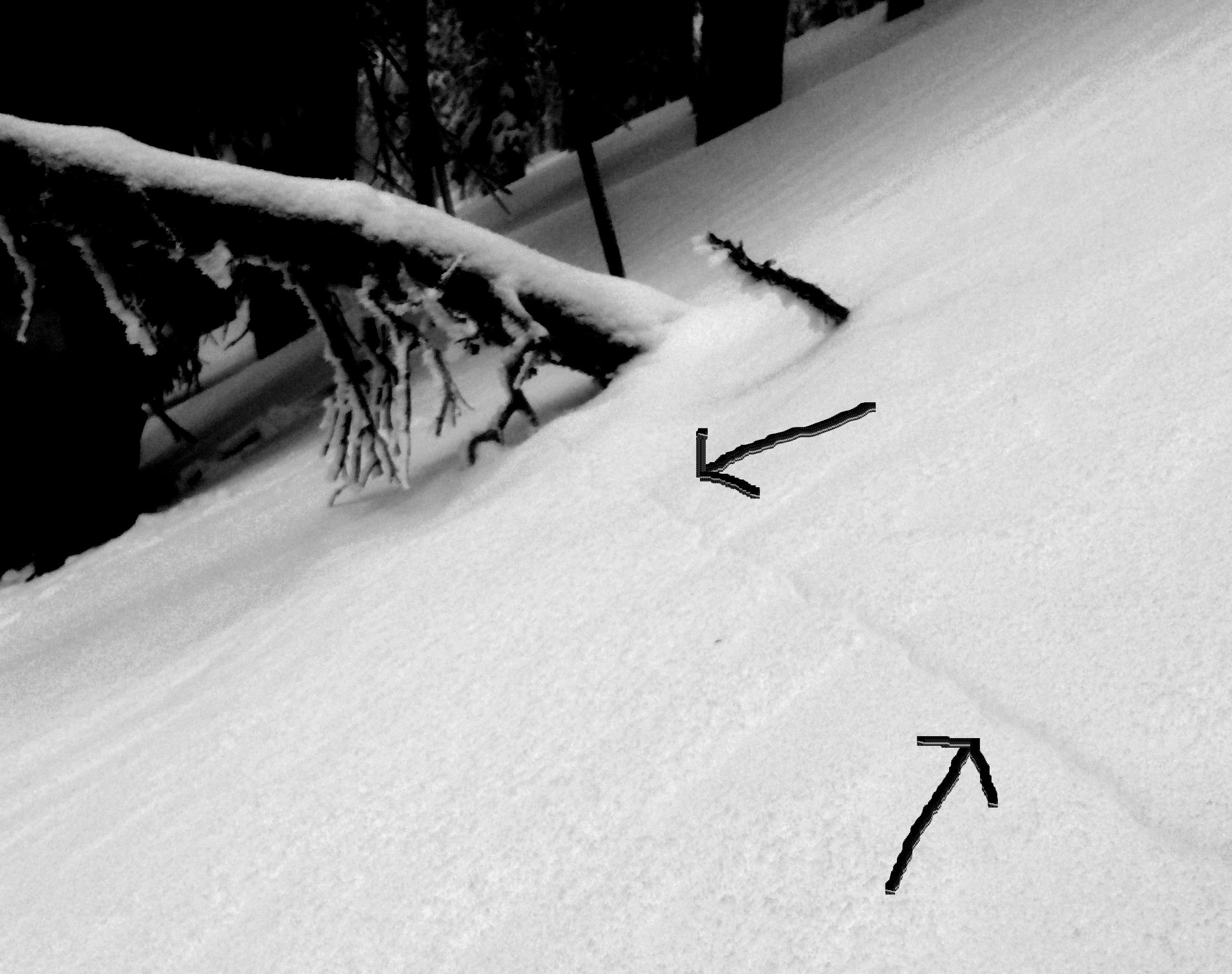
Widespread cracking and whumpfing today (January 18, 2019) on 30° NW slopes near Alison Clay slide path. Arrows drawn on image show cracks that where shooting 50+ feet from under our skis.
Explosives deployed at Arizona Snowbowl resulted in localized slab releases with 6-8 inch crown fractures. Reminder: Outside of the ski area, there is no avalanche control work.
Final Thoughts
Backcountry permits are required for travel in the Kachina Peaks Wilderness and available at local USFS locations, as well as, at the Agassiz Lodge on Saturday and Sunday 8:30 -11:30 a.m. Permits are currently not being issued due to the partial government shutdown.
For information on uphill travel within the Arizona Snowbowl ski area, please refer to www.flagstaffuphill.com and https://www.snowbowl.ski/the-mountain/uphill-access/ for details. Access to the Kachina Peaks Wilderness is available from the lower lots at Snowbowl via the Humphreys Trail and Kachina Trail.
Weather
During the week, moderate winds out of the south and southwest have accompanied the precipitation. Stronger winds, within threshold snow transporting velocities, characterized Thursday evening’s storm. On Friday January 18th winds are forcasted to shift to westerly. blowing between 22-32 mph, gradually diminishing later in the day.
Clearing to partly cloudy skies and warming and drying conditions will prevail during the weekend and into next week. Winds will pick up on Sunday night and continue on Martin Luther King Day, Monday January 21st. These winds may redistribute some snow that fell during the past week.
On Friday morning, January 18th, the Inner Basin SNOTEL site (Snowslide) reported a snow depth of 36 inches (91 cm) with about 0.5 inches of new SWE in the last 12 hours at 9,730 feet. Arizona Snowbowl reported a settled base of 52 inches (132 cm) at 10,800 feet, 6 inches of which have fallen in the last 24 hours. So far this winter, 120 inches (305 cm) of snow have fallen at the mid-mountain study site. Since January 11th, SNOTEL temperatures have ranged between 7°F on January 12th, and 38°F on January 17th. For the same period, the AZ Snowbowl Top Patol Station (ASBTP 11,555 feet) temperatures ranged between 12°F on January 14th, and 30.5°F on January 12th.
Authored/Edited By: Troy Marino, David Lovejoy, Derik Spice
Avalanche Problems/Characters
The avalanche problem/character describes part of the current avalanche danger. However because we only realease a summary once a week, the current avalanche problem will likely change.
Understanding avalanche problems is essential, because it allows you to determine your approach and strategies to risk treatment. Below are brief descriptions of avalanche problems/characters, and links to detailed information on the problem, formation, patterns, recognition, and avoidance strategies.
Avalanche Problems Explained
Also see the North American Danger Scale.
Loose Dry

Release of dry unconsolidated snow. These avalanches typically occur within layers of soft snow near the surface of the snowpack. Loose-dry avalanches start at a point and entrain snow as they move downhill, forming a fan-shaped avalanche. Other names for loose-dry avalanches include point-release avalanches or sluffs. Loose-dry avalanches can trigger slab avalanches that break into deeper snow layers.
Loose Dry avalanches are usually relatively harmless to people. They can be hazardous if you are caught and carried into or over a terrain trap (e.g. gully, rocks, dense timber, cliff, crevasse) or down a long slope. Avoid traveling in or above terrain traps when Loose Dry avalanches are likely. more info
Storm Slab
Release of a soft cohesive layer (a slab) of new snow that breaks within the storm snow or on the old snow surface. Storm-slab problems typically last between a few hours and few days. Storm-slabs that form over a persistent weak layer (surface hoar, depth hoar, or near-surface facets) may be termed Persistent Slabs or may develop into Persistent Slabs.
You can reduce your risk from Storm Slabs by waiting a day or two after a storm before venturing into steep terrain. Storm slabs are most dangerous on slopes with terrain traps, such as timber, gullies, over cliffs, or terrain features that make it difficult for a rider to escape off the side. more info
Wind Slab
Release of a cohesive layer of snow (a slab) formed by the wind. Wind typically transports snow from the upwind sides of terrain features and deposits snow on the downwind side. Wind slabs are often smooth and rounded and sometimes sound hollow, and can range from soft to hard. Wind slabs that form over a persistent weak layer (surface hoar, depth hoar, or near-surface facets) may be termed Persistent Slabs or may develop into Persistent Slabs.
Wind Slabs form in specific areas, and are confined to lee and cross-loaded terrain features. They can be avoided by sticking to sheltered or wind-scoured areas. more info
Persistent Slab
Release of a cohesive layer of soft to hard snow (a slab) in the middle to upper snowpack, when the bond to an underlying persistent weak layer breaks. Persistent layers include: surface hoar, depth hoar, near-surface facets, or faceted snow. Persistent weak layers can continue to produce avalanches for days, weeks or even months, making them especially dangerous and tricky. As additional snow and wind events build a thicker slab on top of the persistent weak layer, this avalanche problem may develop into a Deep Persistent Slab.
The best ways to manage the risk from Persistent Slabs is to make conservative terrain choices. They can be triggered by light loads and weeks after the last storm. The slabs often propagate in surprising and unpredictable ways. This makes this problem difficult to predict and manage and requires a wide safety buffer to handle the uncertainty. more info
Deep Persistent Slab

Release of a thick cohesive layer of hard snow (a slab), when the bond breaks between the slab and an underlying persistent weak layer, deep in the snowpack or near the ground. The most common persistent weak layers involved in deep, persistent slabs are depth hoar or facets surrounding a deeply buried crust. Deep Persistent Slabs are typically hard to trigger, are very destructive and dangerous due to the large mass of snow involved, and can persist for months once developed. They are often triggered from areas where the snow is shallow and weak, and are particularly difficult to forecast for and manage. They commonly develop when Persistent Slabs become more deeply buried over time.
Deep Persistent Slabs are destructive and deadly events that can take months to stabilize. You can trigger them from well down in the avalanche path, and after dozens of tracks have crossed the slope. more info
Loose Wet

Release of wet unconsolidated snow or slush. These avalanches typically occur within layers of wet snow near the surface of the snowpack, but they may quickly gouge into lower snowpack layers. Like Loose Dry Avalanches, they start at a point and entrain snow as they move downhill, forming a fan-shaped avalanche. They generally move slowly, but can contain enough mass to cause significant damage to trees, cars or buildings. Other names for loose-wet avalanches include point-release avalanches or sluffs. Loose Wet avalanches can trigger slab avalanches that break into deeper snow layers.
Travel when the snow surface is colder and stronger. Plan your trips to avoid crossing on or under very steep slopes in the afternoon. Move to colder, shadier slopes once the snow surface turns slushly. Avoid steep, sunlit slopes above terrain traps, cliffs areas and long sustained steep pitches. more info
Wet Slab

Release of a cohesive layer of snow (a slab) that is generally moist or wet when the flow of liquid water weakens the bond between the slab and the surface below (snow or ground). They often occur during prolonged warming events and/or rain-on-snow events. Wet Slabs can be very destructive.
Avoid terrain where and when you suspect Wet Slab avalanche activity. Give yourself a wide safety buffer to handle the uncertainty. more info
Cornice Fall

Cornice Fall is the release of an overhanging mass of snow that forms as the wind moves snow over a sharp terrain feature, such as a ridge, and deposits snow on the downwind (leeward) side. Cornices range in size from small wind lips of soft snow to large overhangs of hard snow that are 30 feet (10 meters) or taller. They can break off the terrain suddenly and pull back onto the ridge top and catch people by surprise even on the flat ground above the slope. Even small cornices can have enough mass to be destructive and deadly. Cornice Fall can entrain loose surface snow or trigger slab avalanches.
Cornices can never be trusted and avoiding them is necessary for safe backcountry travel. Stay well back from ridge line areas with cornices. They often overhang the ridge edge can be triggered remotely. Avoid areas underneath cornices. Even small Cornice Fall can trigger a larger avalanche and large Cornice Fall can easily crush a human. Periods of significant temperature warm-up are times to be particularly aware.
Large cornices are generally rare in Arizona, but they have been observed during very snowy winters. more info
Glide

Release of the entire snow cover as a result of gliding over the ground. Glide avalanches can be composed of wet, moist, or almost entirely dry snow. They typically occur in very specific paths, where the slope is steep enough and the ground surface is relatively smooth. The are often proceeded by full depth cracks (glide cracks), though the time between the appearance of a crack and an avalanche can vary between seconds and months. Glide avalanches are unlikely to be triggered by a person, are nearly impossible to forecast, and thus pose a hazard that is extremely difficult to manage.
Predicting the release of Glide Avalanches is very challenging. Because Glide Avalanches only occur on very specific slopes, safe travel relies on identifying and avoiding those slopes. Glide cracks are a significant indicator, as are recent Glide Avalanches.
Glide avalanches are very uncommon in Arizona. more info
