Snowpack Summary for Wednesday, December 4, 2019 8:15 AM November Natural Avalanches and Future Potential
This summary expired Dec. 06, 2019 8:15 AM
Flagstaff, Arizona - Backcountry of The San Francisco Peaks and Kachina Peaks Wilderness
There was a natural avalanche near 11,700 ft on a northeasterly slope in Humphrey's Cirque near treeline. Another natural avalanche on more northerly through northeasterly aspects occurred near the top of Core Ridge. Both avalanches appeared to have initialed at the old and new snow interface in a graupel layer, likely releasing sometime on November 29th or early on November 30th.
Arizona Snowbowl Ski Patrol observed natural avalanche debris from the evening of the 29th and triggered an avalanche with explosives on Saturday, November 30th, on a north aspect at 12,000'. Strong south and southwest winds during the Thanksgiving storm loaded north and east aspects.
The storm snow has settled rapidly over the last few days, and evidence of increasing stability has been noted. However the graupel layer (discussed above) did indicate a propensity to propagate failures during December 1 stability tests.
More rain and snow is expected Wednesday through Thursday morning with 9 to 15 inches and south-southwest-west winds forecasted near treeline. Rain is forecasted below 9,000 ft.
Coverage is approximately 1.5 meters, excluding wind scoured areas and areas that avalanched during the last storm. View recent snow study pits. Measurements of 2 meters of snow were reported from ~12,000 ft in Humphrey's Cirque on December 2nd.
Coverage for ski touring is fantastic for early December, but early season hazards such as downed trees, stumps, and boulders may still remain hidden near the surface at lower elevations. Coverage above 9,000 ft is generally 1+ meter of snow. Good touring has been found all the way down to 7,500 ft on slopes with few rocks and plant debris.
Current Problems (noninclusive) more info

This problem should be confined to near and above treeline terrain. Wind Slabs are most reactive during formation, and the first day or two after.

Should we get significant lower elevation rain, then rooftops fat from late November snow may unexpectedly shed. Rooftops that face north, northeast and east are the most suspect, as that is where most of the snow has loaded.
Wet avalanche probability will decrease dramatically as the temperature drops below freezing Wednesday night and Thursday morning.
Images
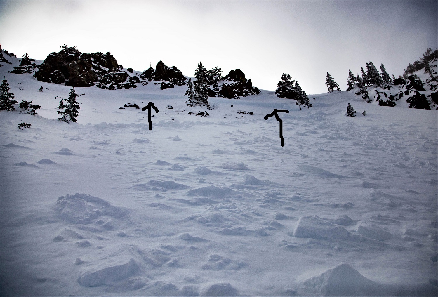
Avalanche in Humphreys Cirque. Arrows show 1 meter tall crown line. Likely occurred sometime Fri. to Sat. morning (Nov 29/30). Sunday, December 1 photo by Tanner Porter. See overall comments above.
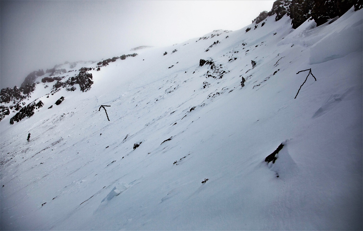
Avalanche on Core Ridge. Arrows show crown line. Likely occurred sometime Fri. to Sat. morning (Nov 29/30). Sunday, December 1 photo by Tanner Porter. See overall comments above.
Final Thoughts
For information on uphill travel within the Arizona Snowbowl ski area, please refer to www.flagstaffuphill.com and https://www.snowbowl.ski/the-mountain/uphill-access/ for details. Access to the Kachina Peaks Wilderness is available from the lower lots at Snowbowl via the Humphreys Trail and Kachina Trail.
Weather
Last week's "White Friday Storm" was the second snowiest November day on record, and the snowiest November 29th day on record for Flagstaff. Our two November storms contained enough moisture to rank November 2019 as the 5th wettest on record for Flagstaff. Since then a slight warming trend has kept temperatures near and above average. Post storm, above freezing temperatures, high relative humidity, light winds and cloud cover have quickly settled the snowpack at high elevations.
A fast moving Pacific trough will cross Arizona on Wednesday and Thursday. The rain/snow line is forecast to start in the 7,500 to 8,500 ft range on Wednesday then drop into the 6,500 to 7,500 range by Thursday morning. Models are showing approximately 1.0 inch of water with this system.
Arizona Snowbowl Ski patrol reports a 45" base at 10,800 ft. Snowslide SNOTEL reports a 35" snow depth, down from a November 30th high of 52".
Since November 29, SNOTEL temperatures have ranged between 6°F on November 30th, and 44°F on December 2nd. ASBTP station (11,555') reported a low of 0°F on November 30th and a high of 41°F on December 2nd.
Authored/Edited By: Troy Marino, Derik Spice
Avalanche Problems/Characters
The avalanche problem/character describes part of the current avalanche danger. However because we only realease a summary once a week, the current avalanche problem will likely change.
Understanding avalanche problems is essential, because it allows you to determine your approach and strategies to risk treatment. Below are brief descriptions of avalanche problems/characters, and links to detailed information on the problem, formation, patterns, recognition, and avoidance strategies.
Avalanche Problems Explained
Also see the North American Danger Scale.
Loose Dry

Release of dry unconsolidated snow. These avalanches typically occur within layers of soft snow near the surface of the snowpack. Loose-dry avalanches start at a point and entrain snow as they move downhill, forming a fan-shaped avalanche. Other names for loose-dry avalanches include point-release avalanches or sluffs. Loose-dry avalanches can trigger slab avalanches that break into deeper snow layers.
Loose Dry avalanches are usually relatively harmless to people. They can be hazardous if you are caught and carried into or over a terrain trap (e.g. gully, rocks, dense timber, cliff, crevasse) or down a long slope. Avoid traveling in or above terrain traps when Loose Dry avalanches are likely. more info
Storm Slab

Release of a soft cohesive layer (a slab) of new snow that breaks within the storm snow or on the old snow surface. Storm-slab problems typically last between a few hours and few days. Storm-slabs that form over a persistent weak layer (surface hoar, depth hoar, or near-surface facets) may be termed Persistent Slabs or may develop into Persistent Slabs.
You can reduce your risk from Storm Slabs by waiting a day or two after a storm before venturing into steep terrain. Storm slabs are most dangerous on slopes with terrain traps, such as timber, gullies, over cliffs, or terrain features that make it difficult for a rider to escape off the side. more info
Wind Slab
Release of a cohesive layer of snow (a slab) formed by the wind. Wind typically transports snow from the upwind sides of terrain features and deposits snow on the downwind side. Wind slabs are often smooth and rounded and sometimes sound hollow, and can range from soft to hard. Wind slabs that form over a persistent weak layer (surface hoar, depth hoar, or near-surface facets) may be termed Persistent Slabs or may develop into Persistent Slabs.
Wind Slabs form in specific areas, and are confined to lee and cross-loaded terrain features. They can be avoided by sticking to sheltered or wind-scoured areas. more info
Persistent Slab

Release of a cohesive layer of soft to hard snow (a slab) in the middle to upper snowpack, when the bond to an underlying persistent weak layer breaks. Persistent layers include: surface hoar, depth hoar, near-surface facets, or faceted snow. Persistent weak layers can continue to produce avalanches for days, weeks or even months, making them especially dangerous and tricky. As additional snow and wind events build a thicker slab on top of the persistent weak layer, this avalanche problem may develop into a Deep Persistent Slab.
The best ways to manage the risk from Persistent Slabs is to make conservative terrain choices. They can be triggered by light loads and weeks after the last storm. The slabs often propagate in surprising and unpredictable ways. This makes this problem difficult to predict and manage and requires a wide safety buffer to handle the uncertainty. more info
Deep Persistent Slab

Release of a thick cohesive layer of hard snow (a slab), when the bond breaks between the slab and an underlying persistent weak layer, deep in the snowpack or near the ground. The most common persistent weak layers involved in deep, persistent slabs are depth hoar or facets surrounding a deeply buried crust. Deep Persistent Slabs are typically hard to trigger, are very destructive and dangerous due to the large mass of snow involved, and can persist for months once developed. They are often triggered from areas where the snow is shallow and weak, and are particularly difficult to forecast for and manage. They commonly develop when Persistent Slabs become more deeply buried over time.
Deep Persistent Slabs are destructive and deadly events that can take months to stabilize. You can trigger them from well down in the avalanche path, and after dozens of tracks have crossed the slope. more info
Loose Wet
Release of wet unconsolidated snow or slush. These avalanches typically occur within layers of wet snow near the surface of the snowpack, but they may quickly gouge into lower snowpack layers. Like Loose Dry Avalanches, they start at a point and entrain snow as they move downhill, forming a fan-shaped avalanche. They generally move slowly, but can contain enough mass to cause significant damage to trees, cars or buildings. Other names for loose-wet avalanches include point-release avalanches or sluffs. Loose Wet avalanches can trigger slab avalanches that break into deeper snow layers.
Travel when the snow surface is colder and stronger. Plan your trips to avoid crossing on or under very steep slopes in the afternoon. Move to colder, shadier slopes once the snow surface turns slushly. Avoid steep, sunlit slopes above terrain traps, cliffs areas and long sustained steep pitches. more info
Wet Slab

Release of a cohesive layer of snow (a slab) that is generally moist or wet when the flow of liquid water weakens the bond between the slab and the surface below (snow or ground). They often occur during prolonged warming events and/or rain-on-snow events. Wet Slabs can be very destructive.
Avoid terrain where and when you suspect Wet Slab avalanche activity. Give yourself a wide safety buffer to handle the uncertainty. more info
Cornice Fall

Cornice Fall is the release of an overhanging mass of snow that forms as the wind moves snow over a sharp terrain feature, such as a ridge, and deposits snow on the downwind (leeward) side. Cornices range in size from small wind lips of soft snow to large overhangs of hard snow that are 30 feet (10 meters) or taller. They can break off the terrain suddenly and pull back onto the ridge top and catch people by surprise even on the flat ground above the slope. Even small cornices can have enough mass to be destructive and deadly. Cornice Fall can entrain loose surface snow or trigger slab avalanches.
Cornices can never be trusted and avoiding them is necessary for safe backcountry travel. Stay well back from ridge line areas with cornices. They often overhang the ridge edge can be triggered remotely. Avoid areas underneath cornices. Even small Cornice Fall can trigger a larger avalanche and large Cornice Fall can easily crush a human. Periods of significant temperature warm-up are times to be particularly aware.
Large cornices are generally rare in Arizona, but they have been observed during very snowy winters. more info
Glide

Release of the entire snow cover as a result of gliding over the ground. Glide avalanches can be composed of wet, moist, or almost entirely dry snow. They typically occur in very specific paths, where the slope is steep enough and the ground surface is relatively smooth. The are often proceeded by full depth cracks (glide cracks), though the time between the appearance of a crack and an avalanche can vary between seconds and months. Glide avalanches are unlikely to be triggered by a person, are nearly impossible to forecast, and thus pose a hazard that is extremely difficult to manage.
Predicting the release of Glide Avalanches is very challenging. Because Glide Avalanches only occur on very specific slopes, safe travel relies on identifying and avoiding those slopes. Glide cracks are a significant indicator, as are recent Glide Avalanches.
Glide avalanches are very uncommon in Arizona. more info
