Snowpack Summary for Friday, February 8, 2019 10:00 PM February Roars in with a large avalanche in Snowslide Canyon
This summary expired Feb. 10, 2019 10:00 PM
Flagstaff, Arizona - Backcountry of The San Francisco Peaks and Kachina Peaks Wilderness
Natural avalanches are possible and human triggered avalanches are likely, primarily above 11,000 on northeast and easterly aspects. Northwest, north and possibly southeast aspects should be considered suspect.
Travel in avalanche terrain near and above treeline will be least reactive on west, southwest, south and southeast slopes, as long as the slopes are not connected to northwest and easterly slopes. Hopefully the right combination of wind/clouds/temperatures will keep the snow in good shape on these sunny slopes. But remember, improving stability does not mean that no avalanche hazards exist.
Snowslide Canyon Bowl avalanched (photo below). This likely occurred between February 5th, Tuesday night and February 6th, Wednesday morning. This is primarily an east aspect with some southeast and northeast. The crown was over 600m wide, and it ran over 1100m (0.7 miles). There is more crown not shown in the photo that wraps around Snowslide Canyon. The average crown height was 1m with a maximum of 1.75m. The avalanche failed on facets near the ground. The bed surface was old snow and crusts. Characteristic classification is HS N R4D4 O.The slope angle was between 35° and 42°.
Watch for reactive persistent weak layers. These may be buried under 2 to 5 feet of slab on east, northeast, north, and northwest aspects. Southeast aspects may be suspect as well, especially on slopes connected to easterly aspects.
Prior to this week's precipitation, wind scoured zones reduced the snowpack down to bedrocks in some areas. Also, sun and wind conspired to create hard snow prior to recent precipitation. Crampons may be helpful where new snow has been wind-scoured down to hard icy snow.
You will find great snow and low avalanche hazard if you stay off and do not get under slopes that are greater than 30°.
Current Problems (noninclusive) more info

Post weekend winds may create slabs on other aspects. As always watch for cross loading in gullies. Slopes just below ridges and on the flanks of shoulders should be considered suspect.

This problem has been found below, near and above treeline on northwest, north, northeast and east aspects. Our most reactive stability-test failures have occurred near and below treeline. The Snowslide Canyon avalanche crownline was above treeline.
Images
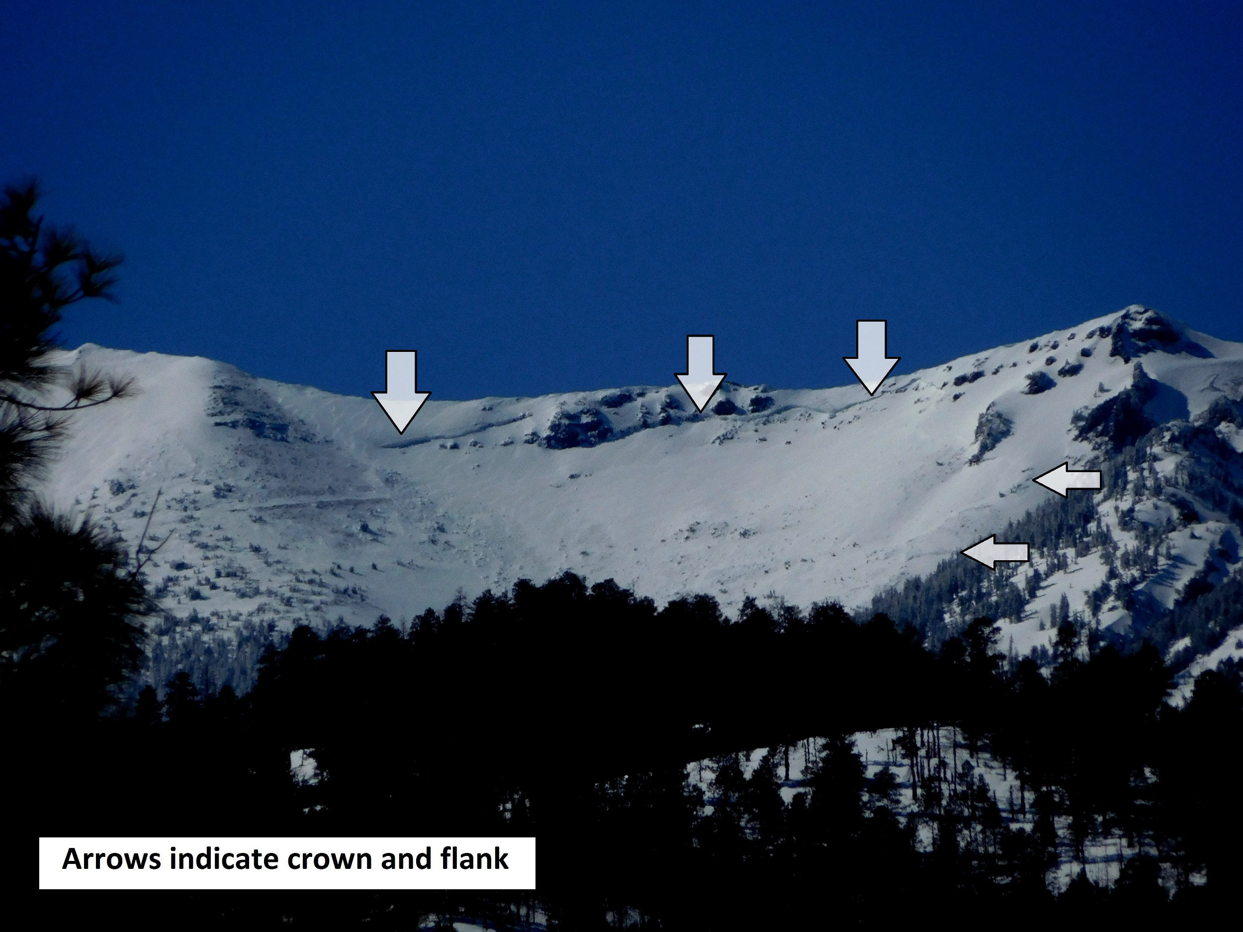
February 7th photo showing the Snowslide Canyon avalanche. Likely triggered on February 5th or 6th by storm/wind slab developing above a persistent slab problem.
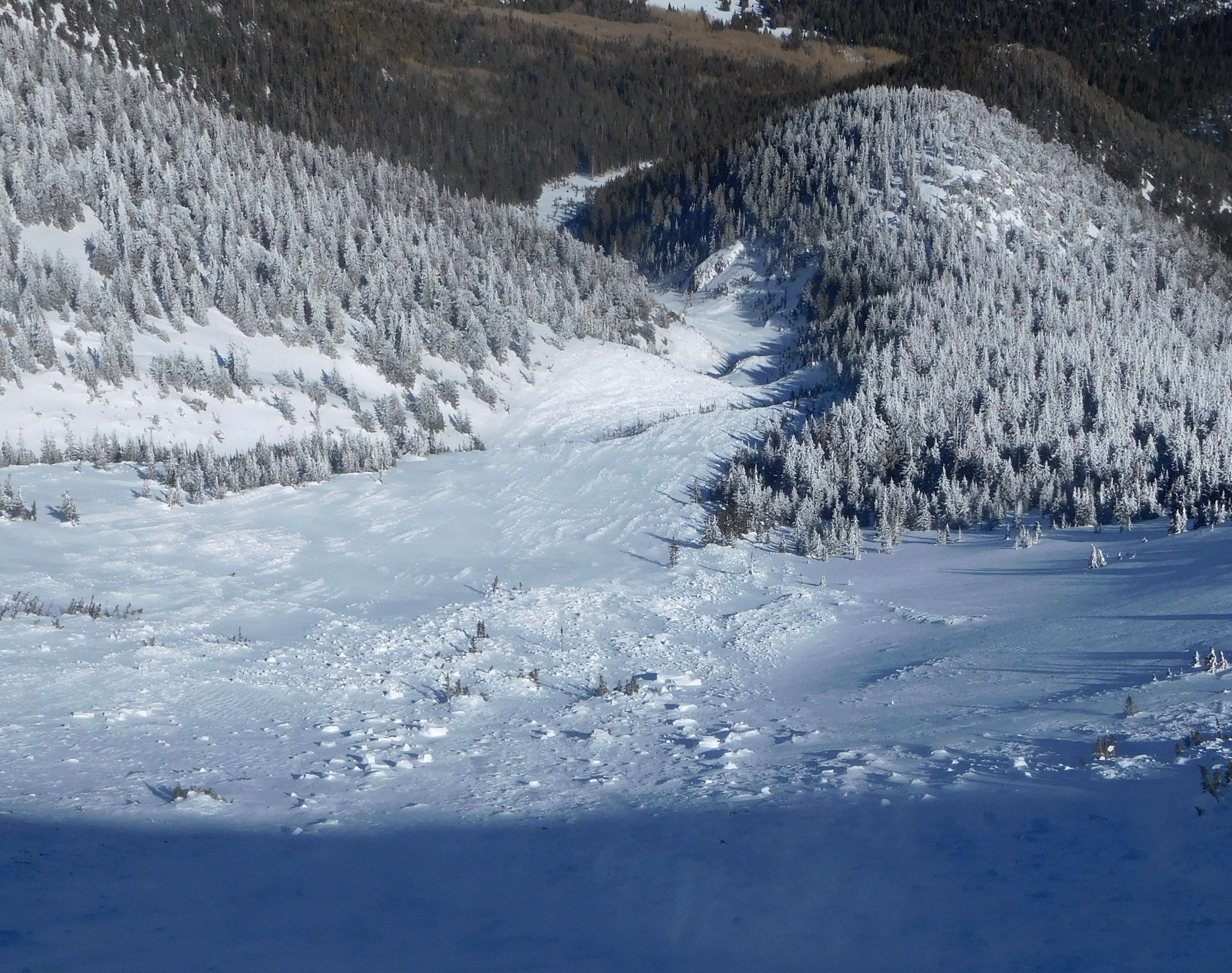
Snowslide Canyon avalanche track. Photo from Feb. 8th.
Final Thoughts
Backcountry permits are required for travel in the Kachina Peaks Wilderness and available at local USFS locations, as well as, at the Agassiz Lodge on Saturday and Sunday 8:30 -11:30.
For information on uphill travel within the Arizona Snowbowl ski area, please refer to www.flagstaffuphill.com and https://www.snowbowl.ski/the-mountain/uphill-access/ for details. Access to the Kachina Peaks Wilderness is available from the lower lots at Snowbowl via the Humphreys Trail and Kachina Trail.
Weather
The past week has been the wettest so far this winter. Arizona snowbowl (10,800') reported 42" of new snow since Feb. 2nd. Twenty inches fell between Feb. 5th and 6th. The Snowslide SNOTEL (9,730') reported 22" since Feb. 2nd and 9" since the 5th. SNOTEL reported 4.8" of new snow water equivalent (SWE) between Feb. 2nd and 6th.
In the aftermath of this storm cycle, cold windy conditions have prevailed. Determining accurate ridge-top wind velocities and direction has been impossible since the ASBTP station's anemometer was incapacitated with rime ice. Lower elevation stations, such as the Flagstaff Pulliam Airport (elev. 6994') reported wind speeds between 15-30 mph, gusting to 30-40 mph, throughout the day on Wednesday February 6th.
Cool blustery days will continue into the weekend with wind chill temperatures as low as -17 F on Friday and a chance of snow showers on Saturday from a passing shortwave trough. Ridge-top wind speeds will continue in the teens and higher, gusting to 30-40 mph out of the southwest throughout the weekend. More unsettled weather and a chance of light precipitation is predicted to develop early in the workweek. A more promising chance for significant new snow will come later in the week. Models disagree on impact and timing, but this appear to be a wet storm with a snowline at or above 8000 feet, probably arriving on Thursday, Feb. 14th.
On Friday morning, Feb. 8th, the Inner Basin SNOTEL site (Snowslide) reported a snow depth of 50" (127 cm) at 9,730'. Arizona Snowbowl reported a settled base of 70" (178 cm) at 10,800'. So far this winter, 170" (432 cm) of snow have fallen at the mid-mountain study site. Since February 1st, SNOTEL temperatures have ranged between 5°F on February 7th, and 35° F on Feb. 2nd. For the same period, ASBTP (11,555') reported temperatures between -6°F on Feb, 7th, and 31°F on Feb. 1st and 2nd.
Authored/Edited By: David Lovejoy, Troy Marino, Derik Spice
Avalanche Problems/Characters
The avalanche problem/character describes part of the current avalanche danger. However because we only realease a summary once a week, the current avalanche problem will likely change.
Understanding avalanche problems is essential, because it allows you to determine your approach and strategies to risk treatment. Below are brief descriptions of avalanche problems/characters, and links to detailed information on the problem, formation, patterns, recognition, and avoidance strategies.
Avalanche Problems Explained
Also see the North American Danger Scale.
Loose Dry

Release of dry unconsolidated snow. These avalanches typically occur within layers of soft snow near the surface of the snowpack. Loose-dry avalanches start at a point and entrain snow as they move downhill, forming a fan-shaped avalanche. Other names for loose-dry avalanches include point-release avalanches or sluffs. Loose-dry avalanches can trigger slab avalanches that break into deeper snow layers.
Loose Dry avalanches are usually relatively harmless to people. They can be hazardous if you are caught and carried into or over a terrain trap (e.g. gully, rocks, dense timber, cliff, crevasse) or down a long slope. Avoid traveling in or above terrain traps when Loose Dry avalanches are likely. more info
Storm Slab

Release of a soft cohesive layer (a slab) of new snow that breaks within the storm snow or on the old snow surface. Storm-slab problems typically last between a few hours and few days. Storm-slabs that form over a persistent weak layer (surface hoar, depth hoar, or near-surface facets) may be termed Persistent Slabs or may develop into Persistent Slabs.
You can reduce your risk from Storm Slabs by waiting a day or two after a storm before venturing into steep terrain. Storm slabs are most dangerous on slopes with terrain traps, such as timber, gullies, over cliffs, or terrain features that make it difficult for a rider to escape off the side. more info
Wind Slab
Release of a cohesive layer of snow (a slab) formed by the wind. Wind typically transports snow from the upwind sides of terrain features and deposits snow on the downwind side. Wind slabs are often smooth and rounded and sometimes sound hollow, and can range from soft to hard. Wind slabs that form over a persistent weak layer (surface hoar, depth hoar, or near-surface facets) may be termed Persistent Slabs or may develop into Persistent Slabs.
Wind Slabs form in specific areas, and are confined to lee and cross-loaded terrain features. They can be avoided by sticking to sheltered or wind-scoured areas. more info
Persistent Slab
Release of a cohesive layer of soft to hard snow (a slab) in the middle to upper snowpack, when the bond to an underlying persistent weak layer breaks. Persistent layers include: surface hoar, depth hoar, near-surface facets, or faceted snow. Persistent weak layers can continue to produce avalanches for days, weeks or even months, making them especially dangerous and tricky. As additional snow and wind events build a thicker slab on top of the persistent weak layer, this avalanche problem may develop into a Deep Persistent Slab.
The best ways to manage the risk from Persistent Slabs is to make conservative terrain choices. They can be triggered by light loads and weeks after the last storm. The slabs often propagate in surprising and unpredictable ways. This makes this problem difficult to predict and manage and requires a wide safety buffer to handle the uncertainty. more info
Deep Persistent Slab

Release of a thick cohesive layer of hard snow (a slab), when the bond breaks between the slab and an underlying persistent weak layer, deep in the snowpack or near the ground. The most common persistent weak layers involved in deep, persistent slabs are depth hoar or facets surrounding a deeply buried crust. Deep Persistent Slabs are typically hard to trigger, are very destructive and dangerous due to the large mass of snow involved, and can persist for months once developed. They are often triggered from areas where the snow is shallow and weak, and are particularly difficult to forecast for and manage. They commonly develop when Persistent Slabs become more deeply buried over time.
Deep Persistent Slabs are destructive and deadly events that can take months to stabilize. You can trigger them from well down in the avalanche path, and after dozens of tracks have crossed the slope. more info
Loose Wet

Release of wet unconsolidated snow or slush. These avalanches typically occur within layers of wet snow near the surface of the snowpack, but they may quickly gouge into lower snowpack layers. Like Loose Dry Avalanches, they start at a point and entrain snow as they move downhill, forming a fan-shaped avalanche. They generally move slowly, but can contain enough mass to cause significant damage to trees, cars or buildings. Other names for loose-wet avalanches include point-release avalanches or sluffs. Loose Wet avalanches can trigger slab avalanches that break into deeper snow layers.
Travel when the snow surface is colder and stronger. Plan your trips to avoid crossing on or under very steep slopes in the afternoon. Move to colder, shadier slopes once the snow surface turns slushly. Avoid steep, sunlit slopes above terrain traps, cliffs areas and long sustained steep pitches. more info
Wet Slab

Release of a cohesive layer of snow (a slab) that is generally moist or wet when the flow of liquid water weakens the bond between the slab and the surface below (snow or ground). They often occur during prolonged warming events and/or rain-on-snow events. Wet Slabs can be very destructive.
Avoid terrain where and when you suspect Wet Slab avalanche activity. Give yourself a wide safety buffer to handle the uncertainty. more info
Cornice Fall

Cornice Fall is the release of an overhanging mass of snow that forms as the wind moves snow over a sharp terrain feature, such as a ridge, and deposits snow on the downwind (leeward) side. Cornices range in size from small wind lips of soft snow to large overhangs of hard snow that are 30 feet (10 meters) or taller. They can break off the terrain suddenly and pull back onto the ridge top and catch people by surprise even on the flat ground above the slope. Even small cornices can have enough mass to be destructive and deadly. Cornice Fall can entrain loose surface snow or trigger slab avalanches.
Cornices can never be trusted and avoiding them is necessary for safe backcountry travel. Stay well back from ridge line areas with cornices. They often overhang the ridge edge can be triggered remotely. Avoid areas underneath cornices. Even small Cornice Fall can trigger a larger avalanche and large Cornice Fall can easily crush a human. Periods of significant temperature warm-up are times to be particularly aware.
Large cornices are generally rare in Arizona, but they have been observed during very snowy winters. more info
Glide

Release of the entire snow cover as a result of gliding over the ground. Glide avalanches can be composed of wet, moist, or almost entirely dry snow. They typically occur in very specific paths, where the slope is steep enough and the ground surface is relatively smooth. The are often proceeded by full depth cracks (glide cracks), though the time between the appearance of a crack and an avalanche can vary between seconds and months. Glide avalanches are unlikely to be triggered by a person, are nearly impossible to forecast, and thus pose a hazard that is extremely difficult to manage.
Predicting the release of Glide Avalanches is very challenging. Because Glide Avalanches only occur on very specific slopes, safe travel relies on identifying and avoiding those slopes. Glide cracks are a significant indicator, as are recent Glide Avalanches.
Glide avalanches are very uncommon in Arizona. more info
