Snowpack Summary for Friday, April 12, 2019 12:45 PM Cooler Weather and Chances for Precipitation
This summary expired Apr. 14, 2019 12:45 PM
Flagstaff, Arizona - Backcountry of The San Francisco Peaks and Kachina Peaks Wilderness
Human triggered storm/wind slab avalanches may be possible with the April 12th storm. With limited accumulation, these avalanches will likely be small. Another storm near the middle of next week may produce more storm/wind slab problems. Wet avalanches are unlikely near and above treeline during the mornings. As the days heat up, natural and human triggered wet avalanches will be possible. New snow will saturate first, possibly producing avalanches that slide on frozen m/f crusts.
This week marks our first snow accumulation since March 22nd. No significant slab avalanches reported since February. Wet avalanche debris were observed recently on a north aspect of Doyle Peak. See below photo.
Read more about springtime touring strategies.
Spring travel strategies.
As the days heat up, natural and human triggered wet avalanches will be possible on southern aspects and any slopes receiving strong solar input. Expect to find wind scoured zones and hard icy snow above treeline. Crampons and ice axes will help prevent falls on steep icy slopes.
When the warm spring weather returns, wet avalanches may be possible on steeper isolated slopes where the snowpack has become saturated by a combination of sunshine and above freezing overnight temperatures. Watch for saturated, and deep slushy snow around terrain traps and any slope steeper than 30°.
Wet avalanche hazard is unpredictable. Warm temperatures and consistent nights with above freezing temperatures are warning signs of an unstable wet snowpack.
Current Problems (noninclusive) more info


"Heating happens fast this time of year, with snow changing in a matter of minutes. Watch for the usual signs of wet instability including roller balls, point releases, and damp, heavy, loose snow. You’ll need to constantly monitor snow surface conditions […] Keep in mind what you’ll be traveling under as you exit the mountains [during the heat of the day]" -Utah Avalanche Center
During warm weather, surface snow will become saturated with water. Deteriorating riding conditions (thick and sticky slush) and rollerballs are an indication that you should move to a colder slope or head home.

Images
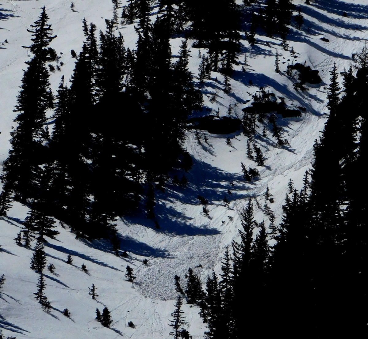
Avalanche debris near 10,500' on north aspect of Doyle Peak, April 09, 2019. This wet loose avalanche likely released on April 8th, when treeline temperatures pushed 50°F.
Final Thoughts
Backcountry permits are required for travel in the Kachina Peaks Wilderness and available at local USFS locations, as well as, at the Agassiz Lodge on Saturday and Sunday 8:30 -11:30.
For information on uphill travel within the Arizona Snowbowl ski area, please refer to www.flagstaffuphill.com and https://www.snowbowl.ski/the-mountain/uphill-access/ for details. Access to the Kachina Peaks Wilderness is available from the lower lots at Snowbowl via the Humphreys Trail and Kachina Trail.
Weather
The past week started out feeling like summer with temperatures 5 to 8 degrees above average, however, bliss was quickly followed by a return to winter with strong winds and a sharp cool down. On Tuesday through Thursday strong winds out of the southwest shifted to the northwest with the passing of a major cold low pressure system to our north. Temperatures in the teens and wind chill below 0°F were recorded. Snow showers were observed, but only 1" accumulated at upper elevations.
On Friday and Saturday April 12 and 13, a significant cold front will brush by to the north, potentially delivering 3-6 inches of new snow and a continuation of windy, cold, unsettled weather. Following this event is a slight warming trend, however, the weather will remain unsettled early in the workweek, with cool nights, warmer days and gusty afternoons. A possibility of snow showers is foretasted through Tuesday April 16. Snow accumulation will probably be light, but storm trajectory and strength are uncertain at the time of publication.
On Friday, April 12th the Inner Basin SNOTEL site (Snowslide) reported a snow depth of 48” (121 cm) at 9,730 feet. Arizona Snowbowl reported a settled base of 88” (224 cm) at 10,800 feet. So far this winter, 328” (833 cm) of snow has fallen at the mid-mountain study site. Since April 5th, SNOTEL temperatures have ranged between 18°F on April 11, and 62°F on April 8. At ASBTP (11,555'), temperatures reported over the last week were between 12°F on April 11, and 50°F on April 8.
Authored/Edited By: David Lovejoy, Troy Marino
Avalanche Problems/Characters
The avalanche problem/character describes part of the current avalanche danger. However because we only realease a summary once a week, the current avalanche problem will likely change.
Understanding avalanche problems is essential, because it allows you to determine your approach and strategies to risk treatment. Below are brief descriptions of avalanche problems/characters, and links to detailed information on the problem, formation, patterns, recognition, and avoidance strategies.
Avalanche Problems Explained
Also see the North American Danger Scale.
Loose Dry

Release of dry unconsolidated snow. These avalanches typically occur within layers of soft snow near the surface of the snowpack. Loose-dry avalanches start at a point and entrain snow as they move downhill, forming a fan-shaped avalanche. Other names for loose-dry avalanches include point-release avalanches or sluffs. Loose-dry avalanches can trigger slab avalanches that break into deeper snow layers.
Loose Dry avalanches are usually relatively harmless to people. They can be hazardous if you are caught and carried into or over a terrain trap (e.g. gully, rocks, dense timber, cliff, crevasse) or down a long slope. Avoid traveling in or above terrain traps when Loose Dry avalanches are likely. more info
Storm Slab

Release of a soft cohesive layer (a slab) of new snow that breaks within the storm snow or on the old snow surface. Storm-slab problems typically last between a few hours and few days. Storm-slabs that form over a persistent weak layer (surface hoar, depth hoar, or near-surface facets) may be termed Persistent Slabs or may develop into Persistent Slabs.
You can reduce your risk from Storm Slabs by waiting a day or two after a storm before venturing into steep terrain. Storm slabs are most dangerous on slopes with terrain traps, such as timber, gullies, over cliffs, or terrain features that make it difficult for a rider to escape off the side. more info
Wind Slab
Release of a cohesive layer of snow (a slab) formed by the wind. Wind typically transports snow from the upwind sides of terrain features and deposits snow on the downwind side. Wind slabs are often smooth and rounded and sometimes sound hollow, and can range from soft to hard. Wind slabs that form over a persistent weak layer (surface hoar, depth hoar, or near-surface facets) may be termed Persistent Slabs or may develop into Persistent Slabs.
Wind Slabs form in specific areas, and are confined to lee and cross-loaded terrain features. They can be avoided by sticking to sheltered or wind-scoured areas. more info
Persistent Slab

Release of a cohesive layer of soft to hard snow (a slab) in the middle to upper snowpack, when the bond to an underlying persistent weak layer breaks. Persistent layers include: surface hoar, depth hoar, near-surface facets, or faceted snow. Persistent weak layers can continue to produce avalanches for days, weeks or even months, making them especially dangerous and tricky. As additional snow and wind events build a thicker slab on top of the persistent weak layer, this avalanche problem may develop into a Deep Persistent Slab.
The best ways to manage the risk from Persistent Slabs is to make conservative terrain choices. They can be triggered by light loads and weeks after the last storm. The slabs often propagate in surprising and unpredictable ways. This makes this problem difficult to predict and manage and requires a wide safety buffer to handle the uncertainty. more info
Deep Persistent Slab

Release of a thick cohesive layer of hard snow (a slab), when the bond breaks between the slab and an underlying persistent weak layer, deep in the snowpack or near the ground. The most common persistent weak layers involved in deep, persistent slabs are depth hoar or facets surrounding a deeply buried crust. Deep Persistent Slabs are typically hard to trigger, are very destructive and dangerous due to the large mass of snow involved, and can persist for months once developed. They are often triggered from areas where the snow is shallow and weak, and are particularly difficult to forecast for and manage. They commonly develop when Persistent Slabs become more deeply buried over time.
Deep Persistent Slabs are destructive and deadly events that can take months to stabilize. You can trigger them from well down in the avalanche path, and after dozens of tracks have crossed the slope. more info
Loose Wet

Release of wet unconsolidated snow or slush. These avalanches typically occur within layers of wet snow near the surface of the snowpack, but they may quickly gouge into lower snowpack layers. Like Loose Dry Avalanches, they start at a point and entrain snow as they move downhill, forming a fan-shaped avalanche. They generally move slowly, but can contain enough mass to cause significant damage to trees, cars or buildings. Other names for loose-wet avalanches include point-release avalanches or sluffs. Loose Wet avalanches can trigger slab avalanches that break into deeper snow layers.
Travel when the snow surface is colder and stronger. Plan your trips to avoid crossing on or under very steep slopes in the afternoon. Move to colder, shadier slopes once the snow surface turns slushly. Avoid steep, sunlit slopes above terrain traps, cliffs areas and long sustained steep pitches. more info
Wet Slab
Release of a cohesive layer of snow (a slab) that is generally moist or wet when the flow of liquid water weakens the bond between the slab and the surface below (snow or ground). They often occur during prolonged warming events and/or rain-on-snow events. Wet Slabs can be very destructive.
Avoid terrain where and when you suspect Wet Slab avalanche activity. Give yourself a wide safety buffer to handle the uncertainty. more info
Cornice Fall
Cornice Fall is the release of an overhanging mass of snow that forms as the wind moves snow over a sharp terrain feature, such as a ridge, and deposits snow on the downwind (leeward) side. Cornices range in size from small wind lips of soft snow to large overhangs of hard snow that are 30 feet (10 meters) or taller. They can break off the terrain suddenly and pull back onto the ridge top and catch people by surprise even on the flat ground above the slope. Even small cornices can have enough mass to be destructive and deadly. Cornice Fall can entrain loose surface snow or trigger slab avalanches.
Cornices can never be trusted and avoiding them is necessary for safe backcountry travel. Stay well back from ridge line areas with cornices. They often overhang the ridge edge can be triggered remotely. Avoid areas underneath cornices. Even small Cornice Fall can trigger a larger avalanche and large Cornice Fall can easily crush a human. Periods of significant temperature warm-up are times to be particularly aware.
Large cornices are generally rare in Arizona, but they have been observed during very snowy winters. more info
Glide

Release of the entire snow cover as a result of gliding over the ground. Glide avalanches can be composed of wet, moist, or almost entirely dry snow. They typically occur in very specific paths, where the slope is steep enough and the ground surface is relatively smooth. The are often proceeded by full depth cracks (glide cracks), though the time between the appearance of a crack and an avalanche can vary between seconds and months. Glide avalanches are unlikely to be triggered by a person, are nearly impossible to forecast, and thus pose a hazard that is extremely difficult to manage.
Predicting the release of Glide Avalanches is very challenging. Because Glide Avalanches only occur on very specific slopes, safe travel relies on identifying and avoiding those slopes. Glide cracks are a significant indicator, as are recent Glide Avalanches.
Glide avalanches are very uncommon in Arizona. more info
