Snowpack Summary for Friday, January 3, 2020 3:54 PM Have a Safe and Happy New Year!
This summary expired Jan. 05, 2020 3:54 PM
Flagstaff, Arizona - Backcountry of The San Francisco Peaks and Kachina Peaks Wilderness
With warm weather this weekend, small, wet avalanches may be possible on steep slopes - primarily sun exposed slopes below treeline. By Monday, January 6, temperatures are forecast to cool down and wet avalanches will become unlikely. Should a significant storm sneak up, or should temperatures warm significantly, then expect increasing avalanche hazard.
The Christmas storm cycle (36" of snow) produced several natural avalanches. A large storm slab avalanche occurred on the North face of Fremont Peak (Telemark chute). Depth of debris exceeded 2m in some spots. Observations suggest that the failure occurred at or above the new/old snow interface. See below photo. There appeared to be significant avalanche debris near the bottom of the Silverton chute - a northerly aspect to the east of the Telemark chute. Debris from a small storm slab release were noted on a northeast aspect of Doyle Peak (Telescope chute). Some debris was noted on a north aspect of Core Ridge.
Surface hoar was found on Doyle Peak (see photo below). This may become a weak layer, should it persist and become covered by new or windblown snow.
Ice tools and crampons are recommended for safe travel, to help prevent slides for life on hard snow and ice. Watch for new wind slabs and cross-loading of chutes and gullies near ridgetops or in open bowls. However, there is not much powder snow available for transport, and the probability of new wind slabs is decreasing.
Coverage near treeline is generally 1.5m or more. If you are on your game in terms of stability assessment, route finding, and safe travel practices, there is plenty of safe fun to be had. The best snow has been found on wind sheltered terrain between 10,500' and 11,500' (treeline).
Coverage for ski touring on many slopes above 9,500’ is very good for this time of year, but early season hazards such as downed trees, stumps, and boulders may still remain hidden - especially on sunny and wind scoured slopes. At lower elevations (<9000’) new snow will hide obstacles just below the surface. A melt/freeze crust has developed on many slopes below 10,000'.
Current Problems (noninclusive) more info


We noted that small wet slabs were releasing off roofs today in Flagstaff.
Images
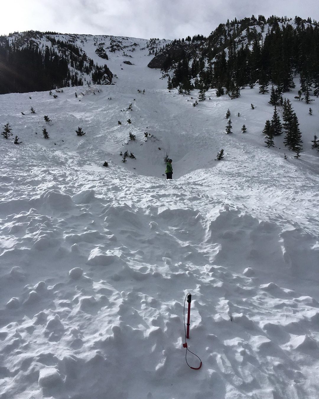
Large natural avalanche debris pile on northerly slope of Fremont Peak. SS-N-R4-D2.5-D3 classification. Occurred during the Christmas storm cycle. Note person and 9' probe. Jan 1 photo by Troy Marino.
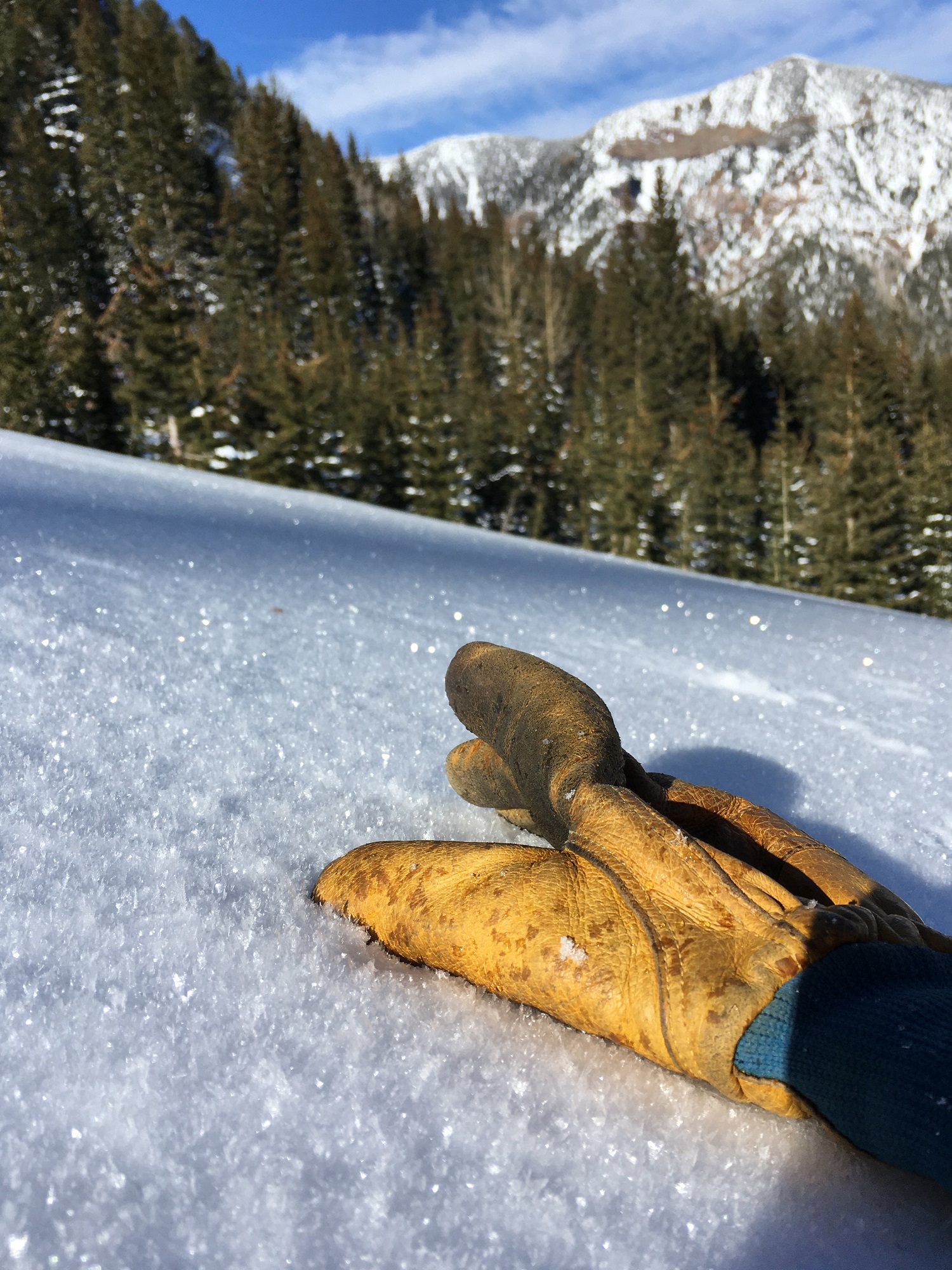
Some surface hoar was found between 10,000 and 10,500' on Northerly slopes of Doyle Peak. Dec. 31 photo from Troy Marino.
Final Thoughts
For information on uphill travel within the Arizona Snowbowl ski area, please refer to www.flagstaffuphill.com and https://www.snowbowl.ski/the-mountain/uphill-access/ for details.
Weather
New Year’s week was windy and cold. On December 28 the coldest high daily temperature so far for this season was recorded. The high for the day was 13° F at ASBTP station (11,555’). Strong winds blew out of the NNE from 10:30 pm on December 28, to 8:30 pm on December 29. Their mean velocities at ASBTP station exceeded 40 mph during many recording intervals, and reached maximum gusts of 70 mph. Wind chill temperatures fell to -20° F.
A brief period of high pressure and some superficial warming on Monday and Tuesday was followed by a dry cold front dropping in from the north on New Year’s Day. The impact lasted through Thursday January 2nd, bringing a return of cold and windy conditions, but only one inch of new snow. Wind chill temperatures have consistently dropped below 0° F throughout the week.
Looking forward, it is shaping up to be a pleasant weekend with the warmest temperatures since December 23rd. Cool, blustery conditions will resume next week, with the greatest chances of precipitation too far out for accurate prediction. For the time being we have entered a less favorable pattern, so expect a period of dry conditions.
Of special note, snowfall so far this season of 129" is just an inch shy of meeting 50% of our mean annual total, so we are doing pretty well for being only 1/3 into our winter season.
Arizona Snowbowl reported a 60" (152 cm) base at 10,800 feet. Snowslide SNOTEL reports a 43" (109 cm) snow depth. So far this winter we have had 129" (328 cm) of snowfall at 10,800 feet.
Since December 27th, SNOTEL temperatures have ranged between -4° F on December 28th and 43°F on January 1st. ASBTP station (11,555 ft) reported a low of 0° F on December 28th and a high of 33° F on December 31st.
Authored/Edited By: Troy Marino, David Lovejoy, Derik Spice
Avalanche Problems/Characters
The avalanche problem/character describes part of the current avalanche danger. However because we only realease a summary once a week, the current avalanche problem will likely change.
Understanding avalanche problems is essential, because it allows you to determine your approach and strategies to risk treatment. Below are brief descriptions of avalanche problems/characters, and links to detailed information on the problem, formation, patterns, recognition, and avoidance strategies.
Avalanche Problems Explained
Also see the North American Danger Scale.
Loose Dry

Release of dry unconsolidated snow. These avalanches typically occur within layers of soft snow near the surface of the snowpack. Loose-dry avalanches start at a point and entrain snow as they move downhill, forming a fan-shaped avalanche. Other names for loose-dry avalanches include point-release avalanches or sluffs. Loose-dry avalanches can trigger slab avalanches that break into deeper snow layers.
Loose Dry avalanches are usually relatively harmless to people. They can be hazardous if you are caught and carried into or over a terrain trap (e.g. gully, rocks, dense timber, cliff, crevasse) or down a long slope. Avoid traveling in or above terrain traps when Loose Dry avalanches are likely. more info
Storm Slab

Release of a soft cohesive layer (a slab) of new snow that breaks within the storm snow or on the old snow surface. Storm-slab problems typically last between a few hours and few days. Storm-slabs that form over a persistent weak layer (surface hoar, depth hoar, or near-surface facets) may be termed Persistent Slabs or may develop into Persistent Slabs.
You can reduce your risk from Storm Slabs by waiting a day or two after a storm before venturing into steep terrain. Storm slabs are most dangerous on slopes with terrain traps, such as timber, gullies, over cliffs, or terrain features that make it difficult for a rider to escape off the side. more info
Wind Slab
Release of a cohesive layer of snow (a slab) formed by the wind. Wind typically transports snow from the upwind sides of terrain features and deposits snow on the downwind side. Wind slabs are often smooth and rounded and sometimes sound hollow, and can range from soft to hard. Wind slabs that form over a persistent weak layer (surface hoar, depth hoar, or near-surface facets) may be termed Persistent Slabs or may develop into Persistent Slabs.
Wind Slabs form in specific areas, and are confined to lee and cross-loaded terrain features. They can be avoided by sticking to sheltered or wind-scoured areas. more info
Persistent Slab

Release of a cohesive layer of soft to hard snow (a slab) in the middle to upper snowpack, when the bond to an underlying persistent weak layer breaks. Persistent layers include: surface hoar, depth hoar, near-surface facets, or faceted snow. Persistent weak layers can continue to produce avalanches for days, weeks or even months, making them especially dangerous and tricky. As additional snow and wind events build a thicker slab on top of the persistent weak layer, this avalanche problem may develop into a Deep Persistent Slab.
The best ways to manage the risk from Persistent Slabs is to make conservative terrain choices. They can be triggered by light loads and weeks after the last storm. The slabs often propagate in surprising and unpredictable ways. This makes this problem difficult to predict and manage and requires a wide safety buffer to handle the uncertainty. more info
Deep Persistent Slab

Release of a thick cohesive layer of hard snow (a slab), when the bond breaks between the slab and an underlying persistent weak layer, deep in the snowpack or near the ground. The most common persistent weak layers involved in deep, persistent slabs are depth hoar or facets surrounding a deeply buried crust. Deep Persistent Slabs are typically hard to trigger, are very destructive and dangerous due to the large mass of snow involved, and can persist for months once developed. They are often triggered from areas where the snow is shallow and weak, and are particularly difficult to forecast for and manage. They commonly develop when Persistent Slabs become more deeply buried over time.
Deep Persistent Slabs are destructive and deadly events that can take months to stabilize. You can trigger them from well down in the avalanche path, and after dozens of tracks have crossed the slope. more info
Loose Wet
Release of wet unconsolidated snow or slush. These avalanches typically occur within layers of wet snow near the surface of the snowpack, but they may quickly gouge into lower snowpack layers. Like Loose Dry Avalanches, they start at a point and entrain snow as they move downhill, forming a fan-shaped avalanche. They generally move slowly, but can contain enough mass to cause significant damage to trees, cars or buildings. Other names for loose-wet avalanches include point-release avalanches or sluffs. Loose Wet avalanches can trigger slab avalanches that break into deeper snow layers.
Travel when the snow surface is colder and stronger. Plan your trips to avoid crossing on or under very steep slopes in the afternoon. Move to colder, shadier slopes once the snow surface turns slushly. Avoid steep, sunlit slopes above terrain traps, cliffs areas and long sustained steep pitches. more info
Wet Slab

Release of a cohesive layer of snow (a slab) that is generally moist or wet when the flow of liquid water weakens the bond between the slab and the surface below (snow or ground). They often occur during prolonged warming events and/or rain-on-snow events. Wet Slabs can be very destructive.
Avoid terrain where and when you suspect Wet Slab avalanche activity. Give yourself a wide safety buffer to handle the uncertainty. more info
Cornice Fall

Cornice Fall is the release of an overhanging mass of snow that forms as the wind moves snow over a sharp terrain feature, such as a ridge, and deposits snow on the downwind (leeward) side. Cornices range in size from small wind lips of soft snow to large overhangs of hard snow that are 30 feet (10 meters) or taller. They can break off the terrain suddenly and pull back onto the ridge top and catch people by surprise even on the flat ground above the slope. Even small cornices can have enough mass to be destructive and deadly. Cornice Fall can entrain loose surface snow or trigger slab avalanches.
Cornices can never be trusted and avoiding them is necessary for safe backcountry travel. Stay well back from ridge line areas with cornices. They often overhang the ridge edge can be triggered remotely. Avoid areas underneath cornices. Even small Cornice Fall can trigger a larger avalanche and large Cornice Fall can easily crush a human. Periods of significant temperature warm-up are times to be particularly aware.
Large cornices are generally rare in Arizona, but they have been observed during very snowy winters. more info
Glide

Release of the entire snow cover as a result of gliding over the ground. Glide avalanches can be composed of wet, moist, or almost entirely dry snow. They typically occur in very specific paths, where the slope is steep enough and the ground surface is relatively smooth. The are often proceeded by full depth cracks (glide cracks), though the time between the appearance of a crack and an avalanche can vary between seconds and months. Glide avalanches are unlikely to be triggered by a person, are nearly impossible to forecast, and thus pose a hazard that is extremely difficult to manage.
Predicting the release of Glide Avalanches is very challenging. Because Glide Avalanches only occur on very specific slopes, safe travel relies on identifying and avoiding those slopes. Glide cracks are a significant indicator, as are recent Glide Avalanches.
Glide avalanches are very uncommon in Arizona. more info
