Snowpack Summary for Friday, January 31, 2020 2:11 PM A Few Inches of Fresh and Mid-Season Snowpack Depth
This summary expired Feb. 02, 2020 2:11 PM
Flagstaff, Arizona - Backcountry of The San Francisco Peaks and Kachina Peaks Wilderness
Windblown, re-deposited snow has potentially created areas of unstable wind slab, most likely on south and southwest aspects near and above treeline, and cross-loaded along leeward sides of gullies and spurs. Until slabs stabilize, these could potentially result in small to medium sized avalanches that could be triggered by humans. Until significant additional precipitation or warm temperatures arrive, natural avalanches will be unlikely, but human triggered wind slab avalanches will be possible. At the time of publication, no new slab avalanches had been reported since the Christmas storm cycle.
On the other hand, a recent snow pit from above treeline on a southwestern aspect showed evidence of near surface faceting. These new crystals are forming due to a temperature gradient recently created by cold air temperatures cooling the top 40 cm of an otherwise warm snowpack (see pit profile). So far these facets do not seem to be forming a reactive weak layer, but this development is something to keep an eye on, particularly if this layer gets covered by new snow.
Although the snowpack above treeline is still quite cold, warm periods between mini-storms are showing early signs of moving towards springtime conditions. The snowpack has become denser (stronger) and internal temperatures have become more uniform. The snowpack is progressing toward an "isothermal" state, one in which the entire snowpack is the same temperature (0° C). An isothermal snowpack is more predictable, because persistent weak layers are less apt to develop.
However, it should be noted that this progression could be temporary. It is not unusual for winter to return to northern Arizona after the apparent first signs of spring. Cold, dry snow conditions are frequently experienced in February and even into March.
New snow that fell over the past week has become redeposited as wind slab or vanished via sublimation. Caution is advised when approaching leeward terrain or cross-loaded deposits where wind slabs may have developed. Dangerous wind slab may soon bond to the snowpack underneath and stabilize after 24-48 hours.
Daytime warming will lead to deteriorating stability on sun exposed terrain. Be alert to conditions that change with elevation, aspect, and time of day. Adjust your travel plans accordingly. If snow underfoot becomes wet and slushy, move to cooler terrain.
Video below from Monday January 27, showing snow saltation in the foreground and turbulent suspension in the background.
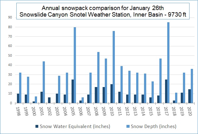
Every year on January 26th we update our annual snowpack comparison graph (posted below). This data is from the Snowslide Canyon Snotel located in the Inner Basin. For January 26th, 2020 the snow depth was 36" and the snow water equivalent (SWE) was 14.7". SWE is used to gauge the amount of liquid water contained within the snowpack. In other words, it is the depth of water that would result if the snowpack was instantly melted.
The 2020 snow depth of 36" is slightly below the 1998-2020 average of 38 inches, and the 2020 SWE of 14.7" is well above the average of 11 inches. From these numbers we can calculate the percent water density of the snow (SWE / depth x 100). For January 2020 the percent water density at the Inner Basin Snotel was 41 percent. For comparison, powder snow is generally <10 percent. This year's density is very high compared to other years. The highest measurement was on 2006 at 50 percent, but the snowpack was only reported as 6" deep on January 26, 2006, a low-snow year and probably saw a lot of melting. This year's high density snowpack is likely the result of several rain on snow events between November and January. Also, the dry spell and warmer temperatures over the last few weeks have settled and densified the snow.
Current Problems (noninclusive) more info


As corn skiing options start to open, timing is key to avoiding hazards associated with a warming snowpack. Keep away from steep, sun exposed terrain as stability deteriorates during the heat of the day. Warming may be accelerated near dark rock outcrops, where solar radiation is intensified by heat absorption. Snow roller or sloughs emanating from rock bands or outcrops are a sign of rising instability.
Images
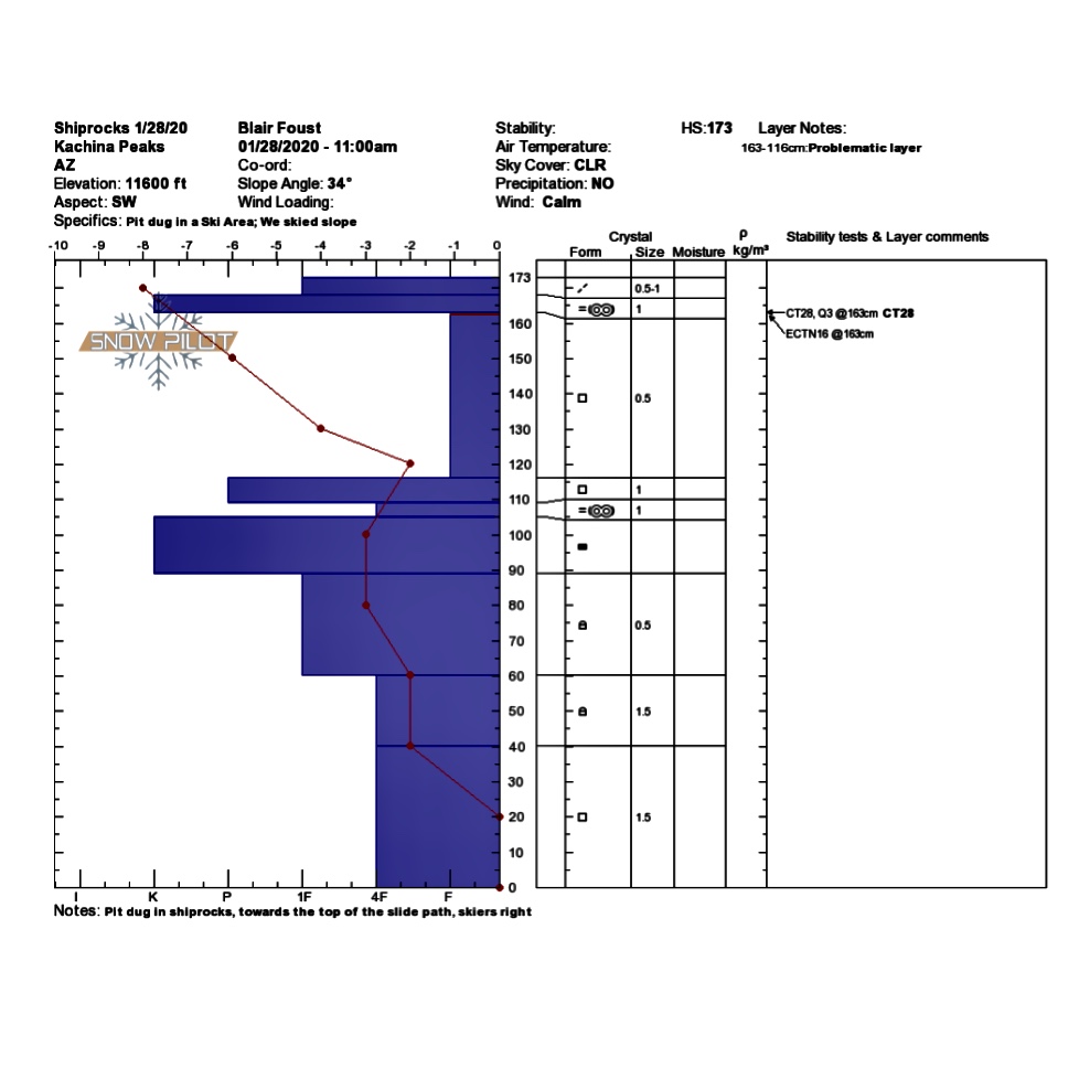
Snow pit profile showing significant temperature gradient in the upper section of the snowpack. Pit by Blair Foust
Final Thoughts
Submit your observations here. You may save a life! The link to this form is now on our home page and snowpack menu.
For information on uphill travel within the Arizona Snowbowl ski area, please refer to www.flagstaffuphill.com and https://www.snowbowl.ski/the-mountain/uphill-access/ for details.
Weather
On Sunday night, a fast moving, short wave trough passed through freshening the snowpack with 6" of new snow at 10,800 feet. A similar storm on Wednesday January 29th failed to produce measurable snow. Post frontal winds out of the west, shifting clockwise to the north and northeast, moved much of the new snow onto southern and southwestern aspects, or sublimated moisture back into the clouds. Average wind speeds in the 20-40 mph range were recorded most of the day on Monday and Thursday in the wake of these low pressure systems.
Looking into the future, wind will persist and even strengthen on Friday, eventually yielding to a calm and pleasant weekend with building high pressure. Fair weather will be short-lived as a cold front dips into our region. It will bring low temperatures, high southwesterly winds, and a chance of snow early in the workweek. The greatest chances of significant precipitation seem to be on Monday night.
Arizona Snowbowl reported a 57” (145 cm) base at 10,800 feet. Snowslide SNOTEL reports a 36” (91 cm) snow depth. So far this winter, we have had 145” (368 cm) of snowfall at 10,800 feet.
Since January 24th, SNOTEL temperatures have ranged between 12° F on January 30th and 41° F on January 25 and 26th. ASBTP station (11,555 ft) reported a low of 9.6° F on January 30th, and a high of 38° F on January 25th.
Authored/Edited By: Troy Marino, David Lovejoy, Derik Spice
Avalanche Problems/Characters
The avalanche problem/character describes part of the current avalanche danger. However because we only realease a summary once a week, the current avalanche problem will likely change.
Understanding avalanche problems is essential, because it allows you to determine your approach and strategies to risk treatment. Below are brief descriptions of avalanche problems/characters, and links to detailed information on the problem, formation, patterns, recognition, and avoidance strategies.
Avalanche Problems Explained
Also see the North American Danger Scale.
Loose Dry

Release of dry unconsolidated snow. These avalanches typically occur within layers of soft snow near the surface of the snowpack. Loose-dry avalanches start at a point and entrain snow as they move downhill, forming a fan-shaped avalanche. Other names for loose-dry avalanches include point-release avalanches or sluffs. Loose-dry avalanches can trigger slab avalanches that break into deeper snow layers.
Loose Dry avalanches are usually relatively harmless to people. They can be hazardous if you are caught and carried into or over a terrain trap (e.g. gully, rocks, dense timber, cliff, crevasse) or down a long slope. Avoid traveling in or above terrain traps when Loose Dry avalanches are likely. more info
Storm Slab

Release of a soft cohesive layer (a slab) of new snow that breaks within the storm snow or on the old snow surface. Storm-slab problems typically last between a few hours and few days. Storm-slabs that form over a persistent weak layer (surface hoar, depth hoar, or near-surface facets) may be termed Persistent Slabs or may develop into Persistent Slabs.
You can reduce your risk from Storm Slabs by waiting a day or two after a storm before venturing into steep terrain. Storm slabs are most dangerous on slopes with terrain traps, such as timber, gullies, over cliffs, or terrain features that make it difficult for a rider to escape off the side. more info
Wind Slab
Release of a cohesive layer of snow (a slab) formed by the wind. Wind typically transports snow from the upwind sides of terrain features and deposits snow on the downwind side. Wind slabs are often smooth and rounded and sometimes sound hollow, and can range from soft to hard. Wind slabs that form over a persistent weak layer (surface hoar, depth hoar, or near-surface facets) may be termed Persistent Slabs or may develop into Persistent Slabs.
Wind Slabs form in specific areas, and are confined to lee and cross-loaded terrain features. They can be avoided by sticking to sheltered or wind-scoured areas. more info
Persistent Slab

Release of a cohesive layer of soft to hard snow (a slab) in the middle to upper snowpack, when the bond to an underlying persistent weak layer breaks. Persistent layers include: surface hoar, depth hoar, near-surface facets, or faceted snow. Persistent weak layers can continue to produce avalanches for days, weeks or even months, making them especially dangerous and tricky. As additional snow and wind events build a thicker slab on top of the persistent weak layer, this avalanche problem may develop into a Deep Persistent Slab.
The best ways to manage the risk from Persistent Slabs is to make conservative terrain choices. They can be triggered by light loads and weeks after the last storm. The slabs often propagate in surprising and unpredictable ways. This makes this problem difficult to predict and manage and requires a wide safety buffer to handle the uncertainty. more info
Deep Persistent Slab

Release of a thick cohesive layer of hard snow (a slab), when the bond breaks between the slab and an underlying persistent weak layer, deep in the snowpack or near the ground. The most common persistent weak layers involved in deep, persistent slabs are depth hoar or facets surrounding a deeply buried crust. Deep Persistent Slabs are typically hard to trigger, are very destructive and dangerous due to the large mass of snow involved, and can persist for months once developed. They are often triggered from areas where the snow is shallow and weak, and are particularly difficult to forecast for and manage. They commonly develop when Persistent Slabs become more deeply buried over time.
Deep Persistent Slabs are destructive and deadly events that can take months to stabilize. You can trigger them from well down in the avalanche path, and after dozens of tracks have crossed the slope. more info
Loose Wet
Release of wet unconsolidated snow or slush. These avalanches typically occur within layers of wet snow near the surface of the snowpack, but they may quickly gouge into lower snowpack layers. Like Loose Dry Avalanches, they start at a point and entrain snow as they move downhill, forming a fan-shaped avalanche. They generally move slowly, but can contain enough mass to cause significant damage to trees, cars or buildings. Other names for loose-wet avalanches include point-release avalanches or sluffs. Loose Wet avalanches can trigger slab avalanches that break into deeper snow layers.
Travel when the snow surface is colder and stronger. Plan your trips to avoid crossing on or under very steep slopes in the afternoon. Move to colder, shadier slopes once the snow surface turns slushly. Avoid steep, sunlit slopes above terrain traps, cliffs areas and long sustained steep pitches. more info
Wet Slab

Release of a cohesive layer of snow (a slab) that is generally moist or wet when the flow of liquid water weakens the bond between the slab and the surface below (snow or ground). They often occur during prolonged warming events and/or rain-on-snow events. Wet Slabs can be very destructive.
Avoid terrain where and when you suspect Wet Slab avalanche activity. Give yourself a wide safety buffer to handle the uncertainty. more info
Cornice Fall

Cornice Fall is the release of an overhanging mass of snow that forms as the wind moves snow over a sharp terrain feature, such as a ridge, and deposits snow on the downwind (leeward) side. Cornices range in size from small wind lips of soft snow to large overhangs of hard snow that are 30 feet (10 meters) or taller. They can break off the terrain suddenly and pull back onto the ridge top and catch people by surprise even on the flat ground above the slope. Even small cornices can have enough mass to be destructive and deadly. Cornice Fall can entrain loose surface snow or trigger slab avalanches.
Cornices can never be trusted and avoiding them is necessary for safe backcountry travel. Stay well back from ridge line areas with cornices. They often overhang the ridge edge can be triggered remotely. Avoid areas underneath cornices. Even small Cornice Fall can trigger a larger avalanche and large Cornice Fall can easily crush a human. Periods of significant temperature warm-up are times to be particularly aware.
Large cornices are generally rare in Arizona, but they have been observed during very snowy winters. more info
Glide

Release of the entire snow cover as a result of gliding over the ground. Glide avalanches can be composed of wet, moist, or almost entirely dry snow. They typically occur in very specific paths, where the slope is steep enough and the ground surface is relatively smooth. The are often proceeded by full depth cracks (glide cracks), though the time between the appearance of a crack and an avalanche can vary between seconds and months. Glide avalanches are unlikely to be triggered by a person, are nearly impossible to forecast, and thus pose a hazard that is extremely difficult to manage.
Predicting the release of Glide Avalanches is very challenging. Because Glide Avalanches only occur on very specific slopes, safe travel relies on identifying and avoiding those slopes. Glide cracks are a significant indicator, as are recent Glide Avalanches.
Glide avalanches are very uncommon in Arizona. more info
