Snowpack Summary for Friday, February 28, 2020 2:02 PM Snowpack stabilizes but winds create concerns
This summary expired Mar. 01, 2020 2:02 PM
Flagstaff, Arizona - Backcountry of The San Francisco Peaks and Kachina Peaks Wilderness
Very strong to gale force winds blew out of the north-northeast between Sunday evening and Tuesday night. Average wind speeds exceeded 50 mph and gusts up to 84 mph were recorded at ASBTP (11,555’). The overall effect of the wind might have created dangerous wind slab, or reduced the hazard by blowing all of the snow away.
Lower elevation terrain has received enough warm temperatures so that the snowpack is nearing an isothermal state. This means the entire snowpack is near the freezing point. Under this condition, the snowpack is generally strong, and has a well-bonded structure when frozen together at night. Rapid warming and air temperatures in the high 40°s F can weaken the structure resulting in wet avalanches. Avoid steep terrain when the snowpack becomes too sloppy for enjoyable travel. In an isothermal snowpack, conditions can degrade rapidly.
Current Problems (noninclusive) more info

Still, pockets and even slopes of unstable wind slab (most likely hard slab) cannot be ruled out. Use caution on potentially wind loaded terrain, especially near ridgelines.

Images
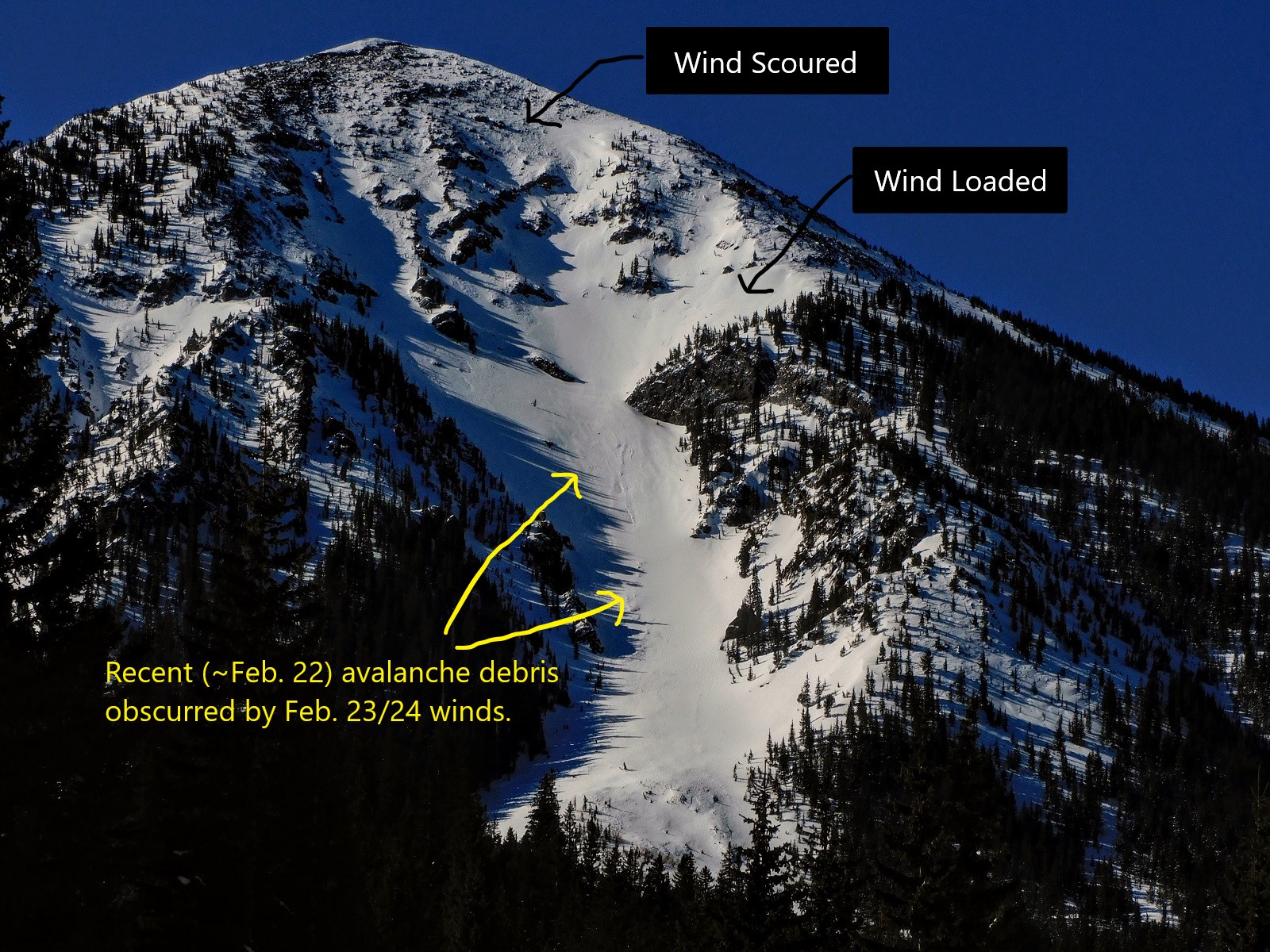
Feb. 24 photo showing wind scouring and loading on the North face of Fremont Peak. Also note the avalanche debris that was obscured by winds. Troy Marino
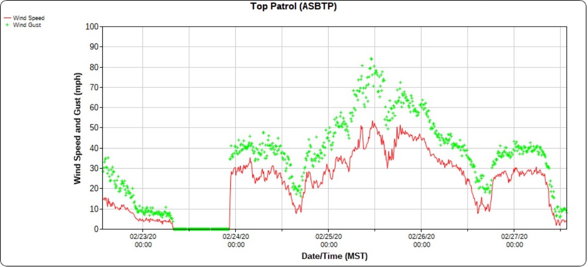
Very strong to gale force winds prevailed during the early part of last week. MesoWest.
Final Thoughts
Always carry the 10 essentials and avalanche rescue gear for wintertime wilderness travel. Practice with your avalanche rescue gear. There is still space available in our avalanche courses.
Submit your observations here. You may save a life! The link to this form is now on our home page and snowpack menu.
For information on uphill travel within the Arizona Snowbowl ski area, please refer to www.flagstaffuphill.com and https://www.snowbowl.ski/the-mountain/uphill-access/ for details.
Weather
The Peaks received 10” – 16” of fresh snow on Saturday February 22nd. The storm began with rain at lower elevations below 8000 feet. Rainfall was even observed at 10,500 feet. The low-pressure system cleared from Coconino county late Saturday night, leaving clear skies and fresh snow in its wake. On Monday a dry cold front replaced the storm, bringing breezy conditions and cold temperatures to the region. Tuesday had the lowest temperatures, dropping down to 7°F at 11,555 feet. Tuesday also brought extreme winds out of the north and northeast causing the ski area to close for the day. Northerly winds continued throughout the week, with speeds in the high 20 mph range.
This weekend will bring clear skies with highs in the mid 30’s and lows in the high 20’s. Models show an approaching low pressure system bringing a potential for 2-6 inches of snow starting Sunday night and lasting until early in the workweek. Moderate to strong winds out of the west and northwest will follow this disturbance, dry and cool temperatures are likely afterwards.
Arizona Snowbowl reported a 58" (147 cm) base at 10,800 feet. Snowslide SNOTEL reports 22" (56 cm) at 9,730 feet. So far this winter, we have had 163" (414 cm) of snowfall at 10,800 feet.
Since February 23rd, SNOTEL temperatures have ranged between 41°F on February 24th and 3°F on February 26th. ASBTP station (11,555 ft) reported a low of 7°F on February 25th and a high of 40°F on February 27th.
Authored/Edited By: David Lovejoy, Troy Marino, Derik Spice
Avalanche Problems/Characters
The avalanche problem/character describes part of the current avalanche danger. However because we only realease a summary once a week, the current avalanche problem will likely change.
Understanding avalanche problems is essential, because it allows you to determine your approach and strategies to risk treatment. Below are brief descriptions of avalanche problems/characters, and links to detailed information on the problem, formation, patterns, recognition, and avoidance strategies.
Avalanche Problems Explained
Also see the North American Danger Scale.
Loose Dry

Release of dry unconsolidated snow. These avalanches typically occur within layers of soft snow near the surface of the snowpack. Loose-dry avalanches start at a point and entrain snow as they move downhill, forming a fan-shaped avalanche. Other names for loose-dry avalanches include point-release avalanches or sluffs. Loose-dry avalanches can trigger slab avalanches that break into deeper snow layers.
Loose Dry avalanches are usually relatively harmless to people. They can be hazardous if you are caught and carried into or over a terrain trap (e.g. gully, rocks, dense timber, cliff, crevasse) or down a long slope. Avoid traveling in or above terrain traps when Loose Dry avalanches are likely. more info
Storm Slab

Release of a soft cohesive layer (a slab) of new snow that breaks within the storm snow or on the old snow surface. Storm-slab problems typically last between a few hours and few days. Storm-slabs that form over a persistent weak layer (surface hoar, depth hoar, or near-surface facets) may be termed Persistent Slabs or may develop into Persistent Slabs.
You can reduce your risk from Storm Slabs by waiting a day or two after a storm before venturing into steep terrain. Storm slabs are most dangerous on slopes with terrain traps, such as timber, gullies, over cliffs, or terrain features that make it difficult for a rider to escape off the side. more info
Wind Slab
Release of a cohesive layer of snow (a slab) formed by the wind. Wind typically transports snow from the upwind sides of terrain features and deposits snow on the downwind side. Wind slabs are often smooth and rounded and sometimes sound hollow, and can range from soft to hard. Wind slabs that form over a persistent weak layer (surface hoar, depth hoar, or near-surface facets) may be termed Persistent Slabs or may develop into Persistent Slabs.
Wind Slabs form in specific areas, and are confined to lee and cross-loaded terrain features. They can be avoided by sticking to sheltered or wind-scoured areas. more info
Persistent Slab

Release of a cohesive layer of soft to hard snow (a slab) in the middle to upper snowpack, when the bond to an underlying persistent weak layer breaks. Persistent layers include: surface hoar, depth hoar, near-surface facets, or faceted snow. Persistent weak layers can continue to produce avalanches for days, weeks or even months, making them especially dangerous and tricky. As additional snow and wind events build a thicker slab on top of the persistent weak layer, this avalanche problem may develop into a Deep Persistent Slab.
The best ways to manage the risk from Persistent Slabs is to make conservative terrain choices. They can be triggered by light loads and weeks after the last storm. The slabs often propagate in surprising and unpredictable ways. This makes this problem difficult to predict and manage and requires a wide safety buffer to handle the uncertainty. more info
Deep Persistent Slab

Release of a thick cohesive layer of hard snow (a slab), when the bond breaks between the slab and an underlying persistent weak layer, deep in the snowpack or near the ground. The most common persistent weak layers involved in deep, persistent slabs are depth hoar or facets surrounding a deeply buried crust. Deep Persistent Slabs are typically hard to trigger, are very destructive and dangerous due to the large mass of snow involved, and can persist for months once developed. They are often triggered from areas where the snow is shallow and weak, and are particularly difficult to forecast for and manage. They commonly develop when Persistent Slabs become more deeply buried over time.
Deep Persistent Slabs are destructive and deadly events that can take months to stabilize. You can trigger them from well down in the avalanche path, and after dozens of tracks have crossed the slope. more info
Loose Wet
Release of wet unconsolidated snow or slush. These avalanches typically occur within layers of wet snow near the surface of the snowpack, but they may quickly gouge into lower snowpack layers. Like Loose Dry Avalanches, they start at a point and entrain snow as they move downhill, forming a fan-shaped avalanche. They generally move slowly, but can contain enough mass to cause significant damage to trees, cars or buildings. Other names for loose-wet avalanches include point-release avalanches or sluffs. Loose Wet avalanches can trigger slab avalanches that break into deeper snow layers.
Travel when the snow surface is colder and stronger. Plan your trips to avoid crossing on or under very steep slopes in the afternoon. Move to colder, shadier slopes once the snow surface turns slushly. Avoid steep, sunlit slopes above terrain traps, cliffs areas and long sustained steep pitches. more info
Wet Slab

Release of a cohesive layer of snow (a slab) that is generally moist or wet when the flow of liquid water weakens the bond between the slab and the surface below (snow or ground). They often occur during prolonged warming events and/or rain-on-snow events. Wet Slabs can be very destructive.
Avoid terrain where and when you suspect Wet Slab avalanche activity. Give yourself a wide safety buffer to handle the uncertainty. more info
Cornice Fall

Cornice Fall is the release of an overhanging mass of snow that forms as the wind moves snow over a sharp terrain feature, such as a ridge, and deposits snow on the downwind (leeward) side. Cornices range in size from small wind lips of soft snow to large overhangs of hard snow that are 30 feet (10 meters) or taller. They can break off the terrain suddenly and pull back onto the ridge top and catch people by surprise even on the flat ground above the slope. Even small cornices can have enough mass to be destructive and deadly. Cornice Fall can entrain loose surface snow or trigger slab avalanches.
Cornices can never be trusted and avoiding them is necessary for safe backcountry travel. Stay well back from ridge line areas with cornices. They often overhang the ridge edge can be triggered remotely. Avoid areas underneath cornices. Even small Cornice Fall can trigger a larger avalanche and large Cornice Fall can easily crush a human. Periods of significant temperature warm-up are times to be particularly aware.
Large cornices are generally rare in Arizona, but they have been observed during very snowy winters. more info
Glide

Release of the entire snow cover as a result of gliding over the ground. Glide avalanches can be composed of wet, moist, or almost entirely dry snow. They typically occur in very specific paths, where the slope is steep enough and the ground surface is relatively smooth. The are often proceeded by full depth cracks (glide cracks), though the time between the appearance of a crack and an avalanche can vary between seconds and months. Glide avalanches are unlikely to be triggered by a person, are nearly impossible to forecast, and thus pose a hazard that is extremely difficult to manage.
Predicting the release of Glide Avalanches is very challenging. Because Glide Avalanches only occur on very specific slopes, safe travel relies on identifying and avoiding those slopes. Glide cracks are a significant indicator, as are recent Glide Avalanches.
Glide avalanches are very uncommon in Arizona. more info
