Snowpack Summary for Friday, February 7, 2020 1:31 PM Varying temperatures and winds lead to a variable snowpack
This summary expired Feb. 09, 2020 1:31 PM
Flagstaff, Arizona - Backcountry of The San Francisco Peaks and Kachina Peaks Wilderness
Overall, the snowpack is demonstrating a complex structure, moderate to good strength, and low reactivity. New precipitation, wind loading, and near surface facet growth could alter this equation to higher instability with a storm forecast for Monday.
Wet avalanche activity remains a possibility this weekend, with high temperatures forecast, particularly on southerly aspects. There was one report of a relatively small skier triggered wet slough in the Humphrey's Cirque on Saturday, February 1 (see photo below).
While some older weak layers have been showing evidence of bonding with prolonged warmer temperatures, the possibility for near surface faceting remains with newly formed crusts as colder temperatures return to northern Arizona. Pay particular attention to the temperature profile as a large temperature gradient over a short distance can signify weak facet layer formation and progressive instability. This could become particularly relevant if new snow falls as forecast for the week of February 10.
However, this weekend presents a great opportunity to observe the snow surface and snowpack in detail before next week's forecast snow. Watch for wet slides if temperatures are high and observe the snow surface and structure carefully before the upcoming storm. Yesterday's snow surface can become tomorrow's weak layer or bed surface.
Sloughing from any new snow this next week is possible on firm frozen surfaces. If more significant amounts of snow were to fall this week, 8 inches or more with wind, there is potential for current near surface facets become a significant weak layer under storm slab and wind slab. Pay attention to this week's weather.
Current Problems (noninclusive) more info


Images
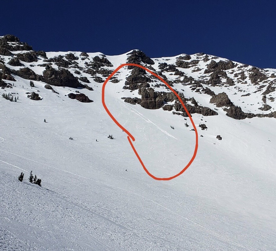
Wet slough reported from Feb 1, Humphrey's Cirque. Photo: Alicia Leggett
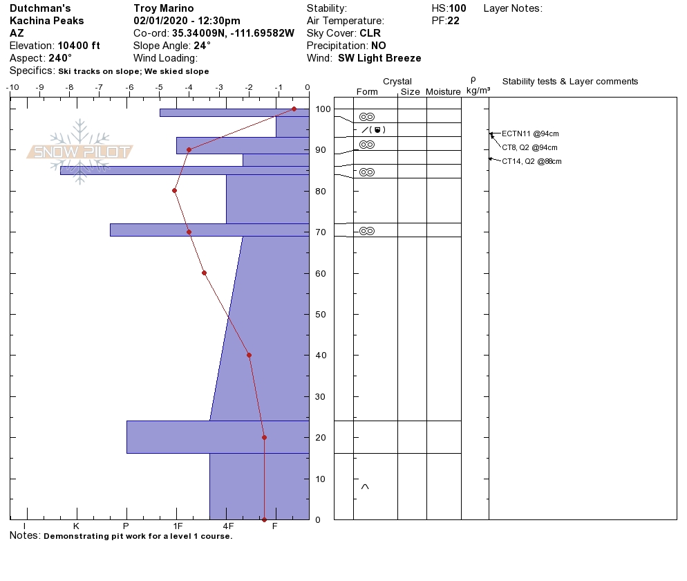
Pit from Dutchman on February 1. Note large temperature gradient near surface. Credit: Troy Marino
Final Thoughts
Submit your observations here. You may save a life! The link to this form is now on our home page and snowpack menu.
For information on uphill travel within the Arizona Snowbowl ski area, please refer to www.flagstaffuphill.com and https://www.snowbowl.ski/the-mountain/uphill-access/ for details.
Weather
A wonderfully warm Groundhog Day weekend was replaced by a cold trough passing to our north. Originally predicted to deliver at least a few inches of new snow, we received only bone-chilling winds out of the southwest and the coldest temperatures of the winter. High temperatures in the low teens and sub 0° F lows were recorded at treeline. Windchill temperatures at ASBTP (11,555’) dropped into -20s Fahrenheit.
Windy and frigid conditions were followed by warming to above average temperatures on Thursday, with generally fair and intermittent breezy weather forecasted through the weekend. We have been experiencing a persistent dry pattern with occasional mid-latitude short wave troughs to the north.
Our next chance for precipitation, and a possible pattern shift will arrive early in the workweek, hopefully as a significant winter storm. Interactions between a cutoff low pressure system, the arctic, and the sub-tropical jet streams may draw in sufficient mid-level moisture to support significant high elevation snowfall. We are looking at this complex interaction of meteorological elements with guarded optimism. Let’s keep our collective fingers crossed. Unsettled weather will characterize much of the upcoming week.
Arizona Snowbowl reported a 52” (132cm) base at 10,800 feet. Snowslide SNOTEL reports a 44” (112cm) snow depth. So far this winter, we have had 145” (368 cm) of snowfall at 10,800 feet.
Since January 21st, SNOTEL temperatures have ranged between -7° F on February 4th and 50° F on February 2nd. ASBTP station (11,555 ft) reported a low of -5° F on February 4th and a high of 47° F on February 1st.
Authored/Edited By: David Lovejoy, Jon Miller, Derik Spice
Avalanche Problems/Characters
The avalanche problem/character describes part of the current avalanche danger. However because we only realease a summary once a week, the current avalanche problem will likely change.
Understanding avalanche problems is essential, because it allows you to determine your approach and strategies to risk treatment. Below are brief descriptions of avalanche problems/characters, and links to detailed information on the problem, formation, patterns, recognition, and avoidance strategies.
Avalanche Problems Explained
Also see the North American Danger Scale.
Loose Dry

Release of dry unconsolidated snow. These avalanches typically occur within layers of soft snow near the surface of the snowpack. Loose-dry avalanches start at a point and entrain snow as they move downhill, forming a fan-shaped avalanche. Other names for loose-dry avalanches include point-release avalanches or sluffs. Loose-dry avalanches can trigger slab avalanches that break into deeper snow layers.
Loose Dry avalanches are usually relatively harmless to people. They can be hazardous if you are caught and carried into or over a terrain trap (e.g. gully, rocks, dense timber, cliff, crevasse) or down a long slope. Avoid traveling in or above terrain traps when Loose Dry avalanches are likely. more info
Storm Slab

Release of a soft cohesive layer (a slab) of new snow that breaks within the storm snow or on the old snow surface. Storm-slab problems typically last between a few hours and few days. Storm-slabs that form over a persistent weak layer (surface hoar, depth hoar, or near-surface facets) may be termed Persistent Slabs or may develop into Persistent Slabs.
You can reduce your risk from Storm Slabs by waiting a day or two after a storm before venturing into steep terrain. Storm slabs are most dangerous on slopes with terrain traps, such as timber, gullies, over cliffs, or terrain features that make it difficult for a rider to escape off the side. more info
Wind Slab
Release of a cohesive layer of snow (a slab) formed by the wind. Wind typically transports snow from the upwind sides of terrain features and deposits snow on the downwind side. Wind slabs are often smooth and rounded and sometimes sound hollow, and can range from soft to hard. Wind slabs that form over a persistent weak layer (surface hoar, depth hoar, or near-surface facets) may be termed Persistent Slabs or may develop into Persistent Slabs.
Wind Slabs form in specific areas, and are confined to lee and cross-loaded terrain features. They can be avoided by sticking to sheltered or wind-scoured areas. more info
Persistent Slab

Release of a cohesive layer of soft to hard snow (a slab) in the middle to upper snowpack, when the bond to an underlying persistent weak layer breaks. Persistent layers include: surface hoar, depth hoar, near-surface facets, or faceted snow. Persistent weak layers can continue to produce avalanches for days, weeks or even months, making them especially dangerous and tricky. As additional snow and wind events build a thicker slab on top of the persistent weak layer, this avalanche problem may develop into a Deep Persistent Slab.
The best ways to manage the risk from Persistent Slabs is to make conservative terrain choices. They can be triggered by light loads and weeks after the last storm. The slabs often propagate in surprising and unpredictable ways. This makes this problem difficult to predict and manage and requires a wide safety buffer to handle the uncertainty. more info
Deep Persistent Slab

Release of a thick cohesive layer of hard snow (a slab), when the bond breaks between the slab and an underlying persistent weak layer, deep in the snowpack or near the ground. The most common persistent weak layers involved in deep, persistent slabs are depth hoar or facets surrounding a deeply buried crust. Deep Persistent Slabs are typically hard to trigger, are very destructive and dangerous due to the large mass of snow involved, and can persist for months once developed. They are often triggered from areas where the snow is shallow and weak, and are particularly difficult to forecast for and manage. They commonly develop when Persistent Slabs become more deeply buried over time.
Deep Persistent Slabs are destructive and deadly events that can take months to stabilize. You can trigger them from well down in the avalanche path, and after dozens of tracks have crossed the slope. more info
Loose Wet
Release of wet unconsolidated snow or slush. These avalanches typically occur within layers of wet snow near the surface of the snowpack, but they may quickly gouge into lower snowpack layers. Like Loose Dry Avalanches, they start at a point and entrain snow as they move downhill, forming a fan-shaped avalanche. They generally move slowly, but can contain enough mass to cause significant damage to trees, cars or buildings. Other names for loose-wet avalanches include point-release avalanches or sluffs. Loose Wet avalanches can trigger slab avalanches that break into deeper snow layers.
Travel when the snow surface is colder and stronger. Plan your trips to avoid crossing on or under very steep slopes in the afternoon. Move to colder, shadier slopes once the snow surface turns slushly. Avoid steep, sunlit slopes above terrain traps, cliffs areas and long sustained steep pitches. more info
Wet Slab

Release of a cohesive layer of snow (a slab) that is generally moist or wet when the flow of liquid water weakens the bond between the slab and the surface below (snow or ground). They often occur during prolonged warming events and/or rain-on-snow events. Wet Slabs can be very destructive.
Avoid terrain where and when you suspect Wet Slab avalanche activity. Give yourself a wide safety buffer to handle the uncertainty. more info
Cornice Fall

Cornice Fall is the release of an overhanging mass of snow that forms as the wind moves snow over a sharp terrain feature, such as a ridge, and deposits snow on the downwind (leeward) side. Cornices range in size from small wind lips of soft snow to large overhangs of hard snow that are 30 feet (10 meters) or taller. They can break off the terrain suddenly and pull back onto the ridge top and catch people by surprise even on the flat ground above the slope. Even small cornices can have enough mass to be destructive and deadly. Cornice Fall can entrain loose surface snow or trigger slab avalanches.
Cornices can never be trusted and avoiding them is necessary for safe backcountry travel. Stay well back from ridge line areas with cornices. They often overhang the ridge edge can be triggered remotely. Avoid areas underneath cornices. Even small Cornice Fall can trigger a larger avalanche and large Cornice Fall can easily crush a human. Periods of significant temperature warm-up are times to be particularly aware.
Large cornices are generally rare in Arizona, but they have been observed during very snowy winters. more info
Glide

Release of the entire snow cover as a result of gliding over the ground. Glide avalanches can be composed of wet, moist, or almost entirely dry snow. They typically occur in very specific paths, where the slope is steep enough and the ground surface is relatively smooth. The are often proceeded by full depth cracks (glide cracks), though the time between the appearance of a crack and an avalanche can vary between seconds and months. Glide avalanches are unlikely to be triggered by a person, are nearly impossible to forecast, and thus pose a hazard that is extremely difficult to manage.
Predicting the release of Glide Avalanches is very challenging. Because Glide Avalanches only occur on very specific slopes, safe travel relies on identifying and avoiding those slopes. Glide cracks are a significant indicator, as are recent Glide Avalanches.
Glide avalanches are very uncommon in Arizona. more info
