Snowpack Summary for Friday, March 13, 2020 3:01 PM 12" at treeline due to Low Pressure, Subtropical Moisture and Warm Air Mass
This summary expired Mar. 15, 2020 3:01 PM
Flagstaff, Arizona - Backcountry of The San Francisco Peaks and Kachina Peaks Wilderness
From Tuesday (Mar. 10) through Thursday morning, the peaks received about 1.5 to 2" of snow water equivalent (SWE), primarily in the form of wet, dense snow above 9,500 ft. Rain levels were highly variable this week, with saturation of the snowpack occurring below @10,000', resulting in sometimes unsupportable travel conditions.
By Friday morning, temperatures dropped and Snowslide SNOTEL reports ~6" of snow accumulation as of 5 am, and 12" + reported at treeline, 11,500'. Moderate southwest winds accompanied the storm, with more snow and wind forecast through Saturday morning.
Prior to this week's precipitation, skiing was highly variable and snow travel was likely to require crampons and an ice axe. These tools may still be needed.
This week has been somewhat similar to our Feb. 22/23 storm, coming in cool, then warm, then cold again. That system caused at least two D1.5-D2 sized avalanches on ~northerly slopes. This recent low pressure system is larger and slower. No new avalanches have been reported since the February 22 storm.
Click Read More for a few things to be aware of this weekend and into next week.
- Venture into this new snow with an "assessment" mindset by selecting conservative terrain in which to gather information
- Check the bonding and reactivity of new storm and wind slabs
- Look for signs of recent avalanches
- Watch for instabilities like cracks shooting out from your skis or board as you skin or ride in fresh snow
- Listen for collapses (whomping) underfoot
- Sunny/warm weather on Sunday and Monday may destabilize new slabs
- Make good decisions upon your observations
- The extended forecast suggest the possibility of more unsettled weather next week - keep your guard elevated.
12" + has fallen since early this morning at treeline, with poor bonding of the storm snow with the old snow surface. Assess conditions based on slope size and consequences...stability tests also revealed reactivity of the near surface facet sandwiches in the snowpack.
There's enough new powder snow and southwesterly winds to build wind slabs. Approach ridges and leeward terrain with caution. Wind can deposit snow 10 times more rapidly than snow falling from the sky multiplying the load on the snowpack. Be suspicious of any steep slope with recent deposits of wind drifted snow.
Near treeline, new snow has accumulated on a mix of surfaces: sastrugi, melt/freeze crusts, rain crusts, and rocks. Ice axe and crampons are recommended for travel within the Kachina Peaks Wilderness. Some windward areas of the peaks were stripped of snow during the February high-wind events, while other areas have retained a 1-2 meter snow depth.
Current Problems (noninclusive) more info

Open slopes and the large bowls above treeline deserve vigorous assessment and respect of the higher consequences of an avalanche. Debris piles could be large with significant destructive power due to the dense, wet snow this week.

Wind typically transports snow from the upwind sides of terrain features and deposits snow on the downwind side. Wind slabs are often smooth and rounded and sometimes sound hollow, and can range from soft to hard. Wind slabs are usually confined to lee and cross-loaded terrain features. They can be avoided by sticking to sheltered or wind-scoured areas.
Images
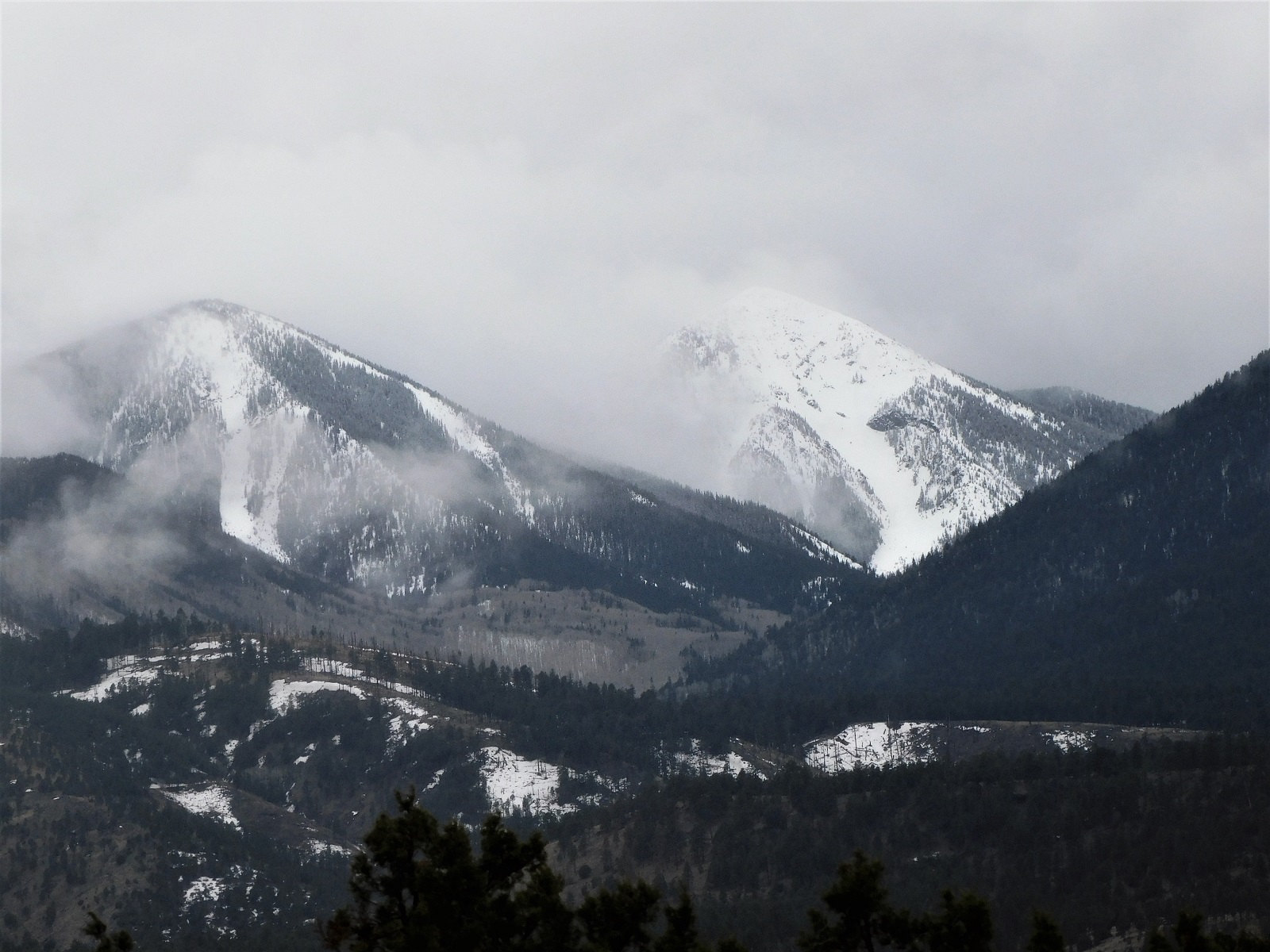
Doyle and Fremont Peaks. Visibility was not ideal, but no avalanche activity noted. Thursday, March 12, 11:45AM. Troy Marino
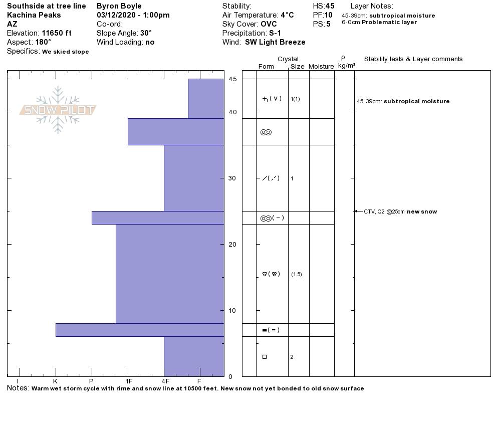
Note the new snow poorly bonding to the old snow surface: CT 10-14 RP. Profile BJ Boyle Treeline south aspect 3-12-20.
Final Thoughts
Always carry the 10 essentials and avalanche rescue gear for wintertime wilderness travel. Submit your observations here. You may save a life!
For information on uphill travel within the Arizona Snowbowl ski area, please refer to www.flagstaffuphill.com and https://www.snowbowl.ski/the-mountain/uphill-access/ for details.
Weather
The weather over the past week has been a complex interaction between a cutoff low pressure cell and its influence over the tropical Jet stream. On Tuesday and Wednesday the pressure system meandered off the coast of southern California, drawing moist warm air from the equatorial Pacific Ocean.
Plumes of warm saturated air and low-lying clouds streamed across northern and central Arizona bringing 1-2 inches of rain to elevations below 8500- 10,000 feet. Mid elevations received either rain, or very dense snow throughout the week, with the freezing altitude varying by day. Eight inches of high density snow fell at 10,800’ on the Peaks early in the storm.
After a brief and intermittent reprieve on Wednesday afternoon and evening, a resumption of precipitation and cooler temperatures are predicted on late Thursday and Friday as the trough finally passes through. Cooler air will lower the snowline to about 7000 feet. Twelve to sixteen inches of new snow are possible by the storm's end. Treeline temperatures have been in the mid 20s to mid 30s °F throughout the last week.
Relatively benign weather will characterize the weekend, but model guidance shows another upper level low developing in the Great Basin. This will bring wind, cool temperatures and possibilities for more precipitation early in the workweek.
Arizona Snowbowl reported a 64" ( 163cm) base at 10,800 feet. Snowslide SNOTEL is reporting a questionable depth of 51" (130cm) at 9,730 feet. So far this winter, 182" (462 cm) of snowfall has been reported at 10,800 feet.
Since Friday March 6th, SNOTEL temperatures have ranged between 49°F on March 12th and 24°F on March 9th. ASBTP station (11,555 ft) reported a low of 15°F on March 9th and a high of 40°F on March 6th.
Authored/Edited By: Troy Marino, David Lovejoy, Derik Spice
Avalanche Problems/Characters
The avalanche problem/character describes part of the current avalanche danger. However because we only realease a summary once a week, the current avalanche problem will likely change.
Understanding avalanche problems is essential, because it allows you to determine your approach and strategies to risk treatment. Below are brief descriptions of avalanche problems/characters, and links to detailed information on the problem, formation, patterns, recognition, and avoidance strategies.
Avalanche Problems Explained
Also see the North American Danger Scale.
Loose Dry

Release of dry unconsolidated snow. These avalanches typically occur within layers of soft snow near the surface of the snowpack. Loose-dry avalanches start at a point and entrain snow as they move downhill, forming a fan-shaped avalanche. Other names for loose-dry avalanches include point-release avalanches or sluffs. Loose-dry avalanches can trigger slab avalanches that break into deeper snow layers.
Loose Dry avalanches are usually relatively harmless to people. They can be hazardous if you are caught and carried into or over a terrain trap (e.g. gully, rocks, dense timber, cliff, crevasse) or down a long slope. Avoid traveling in or above terrain traps when Loose Dry avalanches are likely. more info
Storm Slab
Release of a soft cohesive layer (a slab) of new snow that breaks within the storm snow or on the old snow surface. Storm-slab problems typically last between a few hours and few days. Storm-slabs that form over a persistent weak layer (surface hoar, depth hoar, or near-surface facets) may be termed Persistent Slabs or may develop into Persistent Slabs.
You can reduce your risk from Storm Slabs by waiting a day or two after a storm before venturing into steep terrain. Storm slabs are most dangerous on slopes with terrain traps, such as timber, gullies, over cliffs, or terrain features that make it difficult for a rider to escape off the side. more info
Wind Slab
Release of a cohesive layer of snow (a slab) formed by the wind. Wind typically transports snow from the upwind sides of terrain features and deposits snow on the downwind side. Wind slabs are often smooth and rounded and sometimes sound hollow, and can range from soft to hard. Wind slabs that form over a persistent weak layer (surface hoar, depth hoar, or near-surface facets) may be termed Persistent Slabs or may develop into Persistent Slabs.
Wind Slabs form in specific areas, and are confined to lee and cross-loaded terrain features. They can be avoided by sticking to sheltered or wind-scoured areas. more info
Persistent Slab

Release of a cohesive layer of soft to hard snow (a slab) in the middle to upper snowpack, when the bond to an underlying persistent weak layer breaks. Persistent layers include: surface hoar, depth hoar, near-surface facets, or faceted snow. Persistent weak layers can continue to produce avalanches for days, weeks or even months, making them especially dangerous and tricky. As additional snow and wind events build a thicker slab on top of the persistent weak layer, this avalanche problem may develop into a Deep Persistent Slab.
The best ways to manage the risk from Persistent Slabs is to make conservative terrain choices. They can be triggered by light loads and weeks after the last storm. The slabs often propagate in surprising and unpredictable ways. This makes this problem difficult to predict and manage and requires a wide safety buffer to handle the uncertainty. more info
Deep Persistent Slab

Release of a thick cohesive layer of hard snow (a slab), when the bond breaks between the slab and an underlying persistent weak layer, deep in the snowpack or near the ground. The most common persistent weak layers involved in deep, persistent slabs are depth hoar or facets surrounding a deeply buried crust. Deep Persistent Slabs are typically hard to trigger, are very destructive and dangerous due to the large mass of snow involved, and can persist for months once developed. They are often triggered from areas where the snow is shallow and weak, and are particularly difficult to forecast for and manage. They commonly develop when Persistent Slabs become more deeply buried over time.
Deep Persistent Slabs are destructive and deadly events that can take months to stabilize. You can trigger them from well down in the avalanche path, and after dozens of tracks have crossed the slope. more info
Loose Wet

Release of wet unconsolidated snow or slush. These avalanches typically occur within layers of wet snow near the surface of the snowpack, but they may quickly gouge into lower snowpack layers. Like Loose Dry Avalanches, they start at a point and entrain snow as they move downhill, forming a fan-shaped avalanche. They generally move slowly, but can contain enough mass to cause significant damage to trees, cars or buildings. Other names for loose-wet avalanches include point-release avalanches or sluffs. Loose Wet avalanches can trigger slab avalanches that break into deeper snow layers.
Travel when the snow surface is colder and stronger. Plan your trips to avoid crossing on or under very steep slopes in the afternoon. Move to colder, shadier slopes once the snow surface turns slushly. Avoid steep, sunlit slopes above terrain traps, cliffs areas and long sustained steep pitches. more info
Wet Slab

Release of a cohesive layer of snow (a slab) that is generally moist or wet when the flow of liquid water weakens the bond between the slab and the surface below (snow or ground). They often occur during prolonged warming events and/or rain-on-snow events. Wet Slabs can be very destructive.
Avoid terrain where and when you suspect Wet Slab avalanche activity. Give yourself a wide safety buffer to handle the uncertainty. more info
Cornice Fall

Cornice Fall is the release of an overhanging mass of snow that forms as the wind moves snow over a sharp terrain feature, such as a ridge, and deposits snow on the downwind (leeward) side. Cornices range in size from small wind lips of soft snow to large overhangs of hard snow that are 30 feet (10 meters) or taller. They can break off the terrain suddenly and pull back onto the ridge top and catch people by surprise even on the flat ground above the slope. Even small cornices can have enough mass to be destructive and deadly. Cornice Fall can entrain loose surface snow or trigger slab avalanches.
Cornices can never be trusted and avoiding them is necessary for safe backcountry travel. Stay well back from ridge line areas with cornices. They often overhang the ridge edge can be triggered remotely. Avoid areas underneath cornices. Even small Cornice Fall can trigger a larger avalanche and large Cornice Fall can easily crush a human. Periods of significant temperature warm-up are times to be particularly aware.
Large cornices are generally rare in Arizona, but they have been observed during very snowy winters. more info
Glide

Release of the entire snow cover as a result of gliding over the ground. Glide avalanches can be composed of wet, moist, or almost entirely dry snow. They typically occur in very specific paths, where the slope is steep enough and the ground surface is relatively smooth. The are often proceeded by full depth cracks (glide cracks), though the time between the appearance of a crack and an avalanche can vary between seconds and months. Glide avalanches are unlikely to be triggered by a person, are nearly impossible to forecast, and thus pose a hazard that is extremely difficult to manage.
Predicting the release of Glide Avalanches is very challenging. Because Glide Avalanches only occur on very specific slopes, safe travel relies on identifying and avoiding those slopes. Glide cracks are a significant indicator, as are recent Glide Avalanches.
Glide avalanches are very uncommon in Arizona. more info
