Snowpack Summary for Friday, March 20, 2020 3:52 PM Avalanche Hazard Increases with 32" Storm Total
This summary expired Mar. 22, 2020 3:52 PM
Flagstaff, Arizona - Backcountry of The San Francisco Peaks and Kachina Peaks Wilderness
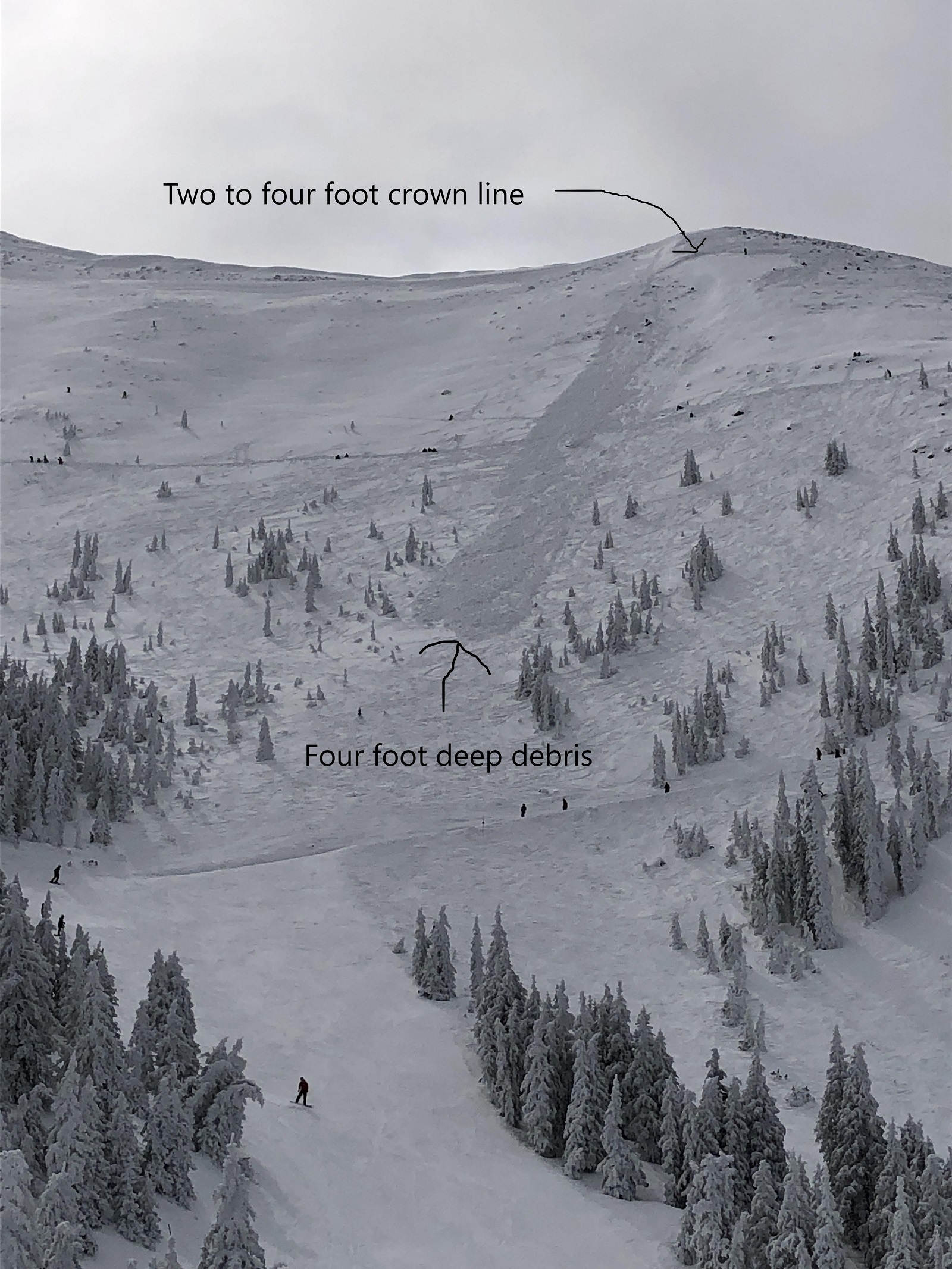
Heavy snowfall was reported on Wednesday afternoon and night, tapering off on Thursday. Winds were moderate out of the southwest. 32 inches of new snow was reported at 10,800 feet by Friday morning. On March 19th, KPAC observers found dramatic signs of instability near the summit of Doyle Peak in the Inner Basin.
Another group on March 20th found propagation propensity at the top of telescope path—Failure of weak layers produced slopewide 'whoomphing', and stability tests proved reactive.
This significant load on a structurally fragile snowpack will increase the potential of dangerous avalanches. For at least the next 24 hours, natural slab avalanches will be possible and human triggered slab avalanches will be likely on steep terrain (30-45 degrees) near and above treeline.
To help prevent the spread of COVID-19, Arizona Snowbowl has suspended all operations until further notice. Snowbowl road is currently closed until further notice, and backcountry access points will require long approaches, e.g. Lockett Meadow road.
Be prepared and recognize the time and physical commitment of such an endeavor. With the ski area closed, the wilderness setting may pose additional challenges for rescue. Make conservative decisions and keep your risk acceptance low, for yourself and the community. Now is not the time to visit a hospital which may be overwhelmed due to COVID-19.
- 90% of human triggered avalanches happen during or within 24 hours of snowfall. Waiting 24 hours before traveling on, or, under steep (>30°) slopes will decrease your likelihood of triggering an avalanche.
- Venture into this new snow with an "assessment" mindset by selecting conservative terrain in which to gather information
- Check the bonding and reactivity of new storm and wind slabs.
- Look for signs of recent avalanches.
- Watch for instabilities like cracks shooting out from your skis or boards as you skin or ride in fresh snow.
- Listen for collapses (whomping) underfoot.
- Post storm sunny/warm weather may destabilize new slabs (spring equinox is March 19th).
- Make good decisions upon your observations.
- The extended forecast suggest even more unsettled weather next week, keep your guard elevated.
This was a wind slab that failed on needles resting on the March 11 rain crust. Recent pits reveal that this may have been an isolated snowpack structure, but KPAC encourages backcountry users to analyze the March 11th rain-crust (and above layers) on, or near treeline slopes, especially where you find wind loading.
Approach ridges and leeward terrain with caution. Wind can deposit snow 10 times more rapidly than snow falling from the sky multiplying the load on the snowpack. Be very suspicious of any steep slope with recent deposits of wind drifted snow.
Even though there is new snow, there may still be areas of exposed ice and hard snow. If you plan to to go above treeline, take an ice axe and crampons as a precaution. Some windward areas of the peaks were stripped of snow during the February high-wind events, while others have retained 3-6 feet of snow depth.
Current Problems (noninclusive) more info


Wind typically transports snow from the upwind side of terrain features and deposits snow on the downwind side. Wind slabs are often smooth and rounded and sometimes sound hollow, and can range from soft to hard. Wind slabs are usually confined to lee and cross-loaded terrain features. They can be avoided by sticking to sheltered or wind-scoured areas.

This crust is now buried 1.5-3 feet below the snow surface. Although we speculate that this condition is more isolated than widespread, reports from a variety of elevations identified this condition, generally on N and NW aspects. Tests results showed: CT12 Q1 and ECT P23, sliding on the 3/11 rain crust, 65cm down.
Images
March 14th avalanche triggered by explosives at AZ Snowbowl. Photo by Chad Trujillo.
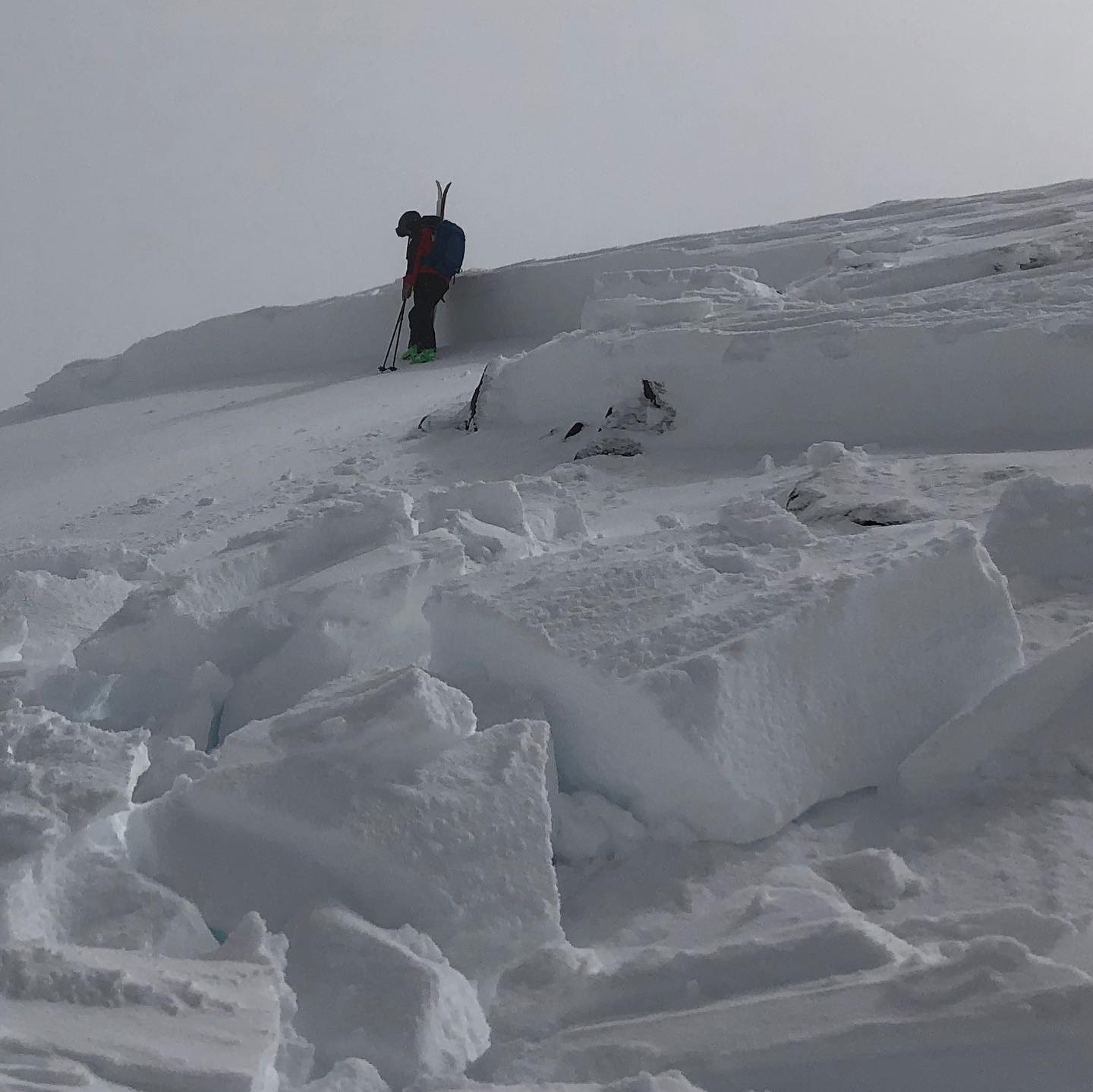
Closer view of the crown line of 3/14 explosive triggered hard slab avalanche. Photo by Ken Galinski,.
Final Thoughts
Always carry the 10 essentials and avalanche rescue gear for wintertime wilderness travel. Submit your observations here. You may save a life!
Weather
A deep trough originating in the northern Pacific has brought 20- 30” of fresh snow to the Peaks, along with low temperatures, and low to moderate winds at treeline. The Arizona Snowbowl Top Patrol (ASTP) station (11,555’) has stopped transmitting as of Wednesday, limiting more recent data.
Forecast models predict a steady warming trend over the weekend and into the early workweek as the low-pressure system matures and dissipates. The recorded high temperature last week was 33°F on Tuesday. Nighttime temperatures dipped down into the mid-teens.
Next week brings the potential for more precipitation. On Monday, a short-wave trough brings a chance of precipitation, preceding a shallow northern born storm system on Tuesday through Thursday. As the week progresses, we will experience moderate to gusty winds and temperatures in the 20-30s degrees F at treeline. Precipitation potential is still uncertain, but March seems to be exiting with a bit of a roar.
Arizona Snowbowl reported a 85” ( 216cm) base at 10,800 feet. Snowslide SNOTEL reports a questionable depth of 61” (155cm) at 9,730 feet. So far this winter, 210" (533cm) of snowfall has been reported at 10,800 feet.
Since Friday March 13th, SNOTEL temperatures have ranged between 48°F on March 15th and 20°F on March 18th. ASBTP station (11,555 ft) reported a low of 16°F on March 16th and a high of 33°F on March 16th.
Authored/Edited By: David Lovejoy, Derik Spice
Avalanche Problems/Characters
The avalanche problem/character describes part of the current avalanche danger. However because we only realease a summary once a week, the current avalanche problem will likely change.
Understanding avalanche problems is essential, because it allows you to determine your approach and strategies to risk treatment. Below are brief descriptions of avalanche problems/characters, and links to detailed information on the problem, formation, patterns, recognition, and avoidance strategies.
Avalanche Problems Explained
Also see the North American Danger Scale.
Loose Dry

Release of dry unconsolidated snow. These avalanches typically occur within layers of soft snow near the surface of the snowpack. Loose-dry avalanches start at a point and entrain snow as they move downhill, forming a fan-shaped avalanche. Other names for loose-dry avalanches include point-release avalanches or sluffs. Loose-dry avalanches can trigger slab avalanches that break into deeper snow layers.
Loose Dry avalanches are usually relatively harmless to people. They can be hazardous if you are caught and carried into or over a terrain trap (e.g. gully, rocks, dense timber, cliff, crevasse) or down a long slope. Avoid traveling in or above terrain traps when Loose Dry avalanches are likely. more info
Storm Slab
Release of a soft cohesive layer (a slab) of new snow that breaks within the storm snow or on the old snow surface. Storm-slab problems typically last between a few hours and few days. Storm-slabs that form over a persistent weak layer (surface hoar, depth hoar, or near-surface facets) may be termed Persistent Slabs or may develop into Persistent Slabs.
You can reduce your risk from Storm Slabs by waiting a day or two after a storm before venturing into steep terrain. Storm slabs are most dangerous on slopes with terrain traps, such as timber, gullies, over cliffs, or terrain features that make it difficult for a rider to escape off the side. more info
Wind Slab
Release of a cohesive layer of snow (a slab) formed by the wind. Wind typically transports snow from the upwind sides of terrain features and deposits snow on the downwind side. Wind slabs are often smooth and rounded and sometimes sound hollow, and can range from soft to hard. Wind slabs that form over a persistent weak layer (surface hoar, depth hoar, or near-surface facets) may be termed Persistent Slabs or may develop into Persistent Slabs.
Wind Slabs form in specific areas, and are confined to lee and cross-loaded terrain features. They can be avoided by sticking to sheltered or wind-scoured areas. more info
Persistent Slab
Release of a cohesive layer of soft to hard snow (a slab) in the middle to upper snowpack, when the bond to an underlying persistent weak layer breaks. Persistent layers include: surface hoar, depth hoar, near-surface facets, or faceted snow. Persistent weak layers can continue to produce avalanches for days, weeks or even months, making them especially dangerous and tricky. As additional snow and wind events build a thicker slab on top of the persistent weak layer, this avalanche problem may develop into a Deep Persistent Slab.
The best ways to manage the risk from Persistent Slabs is to make conservative terrain choices. They can be triggered by light loads and weeks after the last storm. The slabs often propagate in surprising and unpredictable ways. This makes this problem difficult to predict and manage and requires a wide safety buffer to handle the uncertainty. more info
Deep Persistent Slab

Release of a thick cohesive layer of hard snow (a slab), when the bond breaks between the slab and an underlying persistent weak layer, deep in the snowpack or near the ground. The most common persistent weak layers involved in deep, persistent slabs are depth hoar or facets surrounding a deeply buried crust. Deep Persistent Slabs are typically hard to trigger, are very destructive and dangerous due to the large mass of snow involved, and can persist for months once developed. They are often triggered from areas where the snow is shallow and weak, and are particularly difficult to forecast for and manage. They commonly develop when Persistent Slabs become more deeply buried over time.
Deep Persistent Slabs are destructive and deadly events that can take months to stabilize. You can trigger them from well down in the avalanche path, and after dozens of tracks have crossed the slope. more info
Loose Wet

Release of wet unconsolidated snow or slush. These avalanches typically occur within layers of wet snow near the surface of the snowpack, but they may quickly gouge into lower snowpack layers. Like Loose Dry Avalanches, they start at a point and entrain snow as they move downhill, forming a fan-shaped avalanche. They generally move slowly, but can contain enough mass to cause significant damage to trees, cars or buildings. Other names for loose-wet avalanches include point-release avalanches or sluffs. Loose Wet avalanches can trigger slab avalanches that break into deeper snow layers.
Travel when the snow surface is colder and stronger. Plan your trips to avoid crossing on or under very steep slopes in the afternoon. Move to colder, shadier slopes once the snow surface turns slushly. Avoid steep, sunlit slopes above terrain traps, cliffs areas and long sustained steep pitches. more info
Wet Slab

Release of a cohesive layer of snow (a slab) that is generally moist or wet when the flow of liquid water weakens the bond between the slab and the surface below (snow or ground). They often occur during prolonged warming events and/or rain-on-snow events. Wet Slabs can be very destructive.
Avoid terrain where and when you suspect Wet Slab avalanche activity. Give yourself a wide safety buffer to handle the uncertainty. more info
Cornice Fall

Cornice Fall is the release of an overhanging mass of snow that forms as the wind moves snow over a sharp terrain feature, such as a ridge, and deposits snow on the downwind (leeward) side. Cornices range in size from small wind lips of soft snow to large overhangs of hard snow that are 30 feet (10 meters) or taller. They can break off the terrain suddenly and pull back onto the ridge top and catch people by surprise even on the flat ground above the slope. Even small cornices can have enough mass to be destructive and deadly. Cornice Fall can entrain loose surface snow or trigger slab avalanches.
Cornices can never be trusted and avoiding them is necessary for safe backcountry travel. Stay well back from ridge line areas with cornices. They often overhang the ridge edge can be triggered remotely. Avoid areas underneath cornices. Even small Cornice Fall can trigger a larger avalanche and large Cornice Fall can easily crush a human. Periods of significant temperature warm-up are times to be particularly aware.
Large cornices are generally rare in Arizona, but they have been observed during very snowy winters. more info
Glide

Release of the entire snow cover as a result of gliding over the ground. Glide avalanches can be composed of wet, moist, or almost entirely dry snow. They typically occur in very specific paths, where the slope is steep enough and the ground surface is relatively smooth. The are often proceeded by full depth cracks (glide cracks), though the time between the appearance of a crack and an avalanche can vary between seconds and months. Glide avalanches are unlikely to be triggered by a person, are nearly impossible to forecast, and thus pose a hazard that is extremely difficult to manage.
Predicting the release of Glide Avalanches is very challenging. Because Glide Avalanches only occur on very specific slopes, safe travel relies on identifying and avoiding those slopes. Glide cracks are a significant indicator, as are recent Glide Avalanches.
Glide avalanches are very uncommon in Arizona. more info
