Snowpack Summary for Friday, March 27, 2020 4:14 PM USFS, KPAC, American Avalanche Association discourage backcountry skiing...
This summary expired Mar. 29, 2020 4:14 PM
Flagstaff, Arizona - Backcountry of The San Francisco Peaks and Kachina Peaks Wilderness
Currently Snowbowl road remains closed for broader community health and EMS resource management. Long approaches/egresses to snowy backcountry slopes will be challenging and require extra planning, preparedness and effort. Arizona Snowbowl has suspended all operations, including avalanche hazard mitigation and rescue. Treat inbounds terrain as uncontrolled backcountry, which is currently closed to all travel.
New wind slabs near and above treeline, and a persistent slab problem on NW, N and NE slopes above 11,000' may also present potential hazards to backcountry skiers and boarders. 40" of snow accumulated above treeline between March 19-23, creating reactive wind slabs: https://snowpilot.org/sites/default/files/snowpit-profiles/graph-24293.jpg
Light snow accumulation of 2-4” and a significant cool down are predicted on Friday March 27th with a quickly passing cold front.
Click read more for springtime travel advice and recent avalanches.
- There was a relatively small soft slab natural-avalanche in Snowslide Canyon Bowl, likely on March 18 or 19th. See photo below.
- On Saturday morning, March 14, while using explosives in a closed area, AZ Snowbowl Ski Patrol triggered an avalanche on a northwest slope near 11,900 feet. The crown was 2-4' deep. It ran approximately 800' and was about 75' wide. The debris pile was ~4' deep where it stopped above the Spur catwalk. The failure occurred within frozen needles resting on the March 11 rain crust.
- No human triggered slab avalanches reported in the backcountry this season.
KPAC observers found reactive wind slab on Thursday, March 26, from an east facing pit in Snowslide Cirque (11,900’). Both compression tests and an extended column test showed low to moderate strength with high propagation propensity. This condition, no doubt, resulted from last week’s strong southwesterly and westerly winds in the high teens and twenties, gusting above forty miles per hour.
The previously identified weak layer above the March 11th rain crust can not be completely ruled out as a persistent slab trigger. Stability may have improved overall, but dangerous pockets may still exist.
Pits dug on NW-N-NE slopes above 11,000' indicate a persistent slab problem. The weak layer is comprised of needles/facets resting on top of the March 11 rain crust, about 60 to 70cm (2-3’) below the snow surface. It may be possible for a human to initiate a failure in this persistent weak layer, and the consequence could be a large destructive avalanche.
Despite the new snow, wind stripping may have exposed ice and hard snow. If you plan to to go above treeline, take an ice axe and crampons as a precaution. Some windward areas were no doubt stripped by strong winds last week, while others have retained 3-6 feet of snow depth.
Current Problems (noninclusive) more info

Human triggered avalanches are possible in this persistent weak layer, and the consequence could be a large destructive avalanche.

Wind typically transports snow from the upwind side of terrain features and deposits snow on the downwind side. Wind slabs are often smooth and rounded and sometimes sound hollow, and can range from soft to hard. Wind slabs are usually confined to lee and cross-loaded terrain features. They can be avoided by sticking to sheltered or wind-scoured areas.

Images
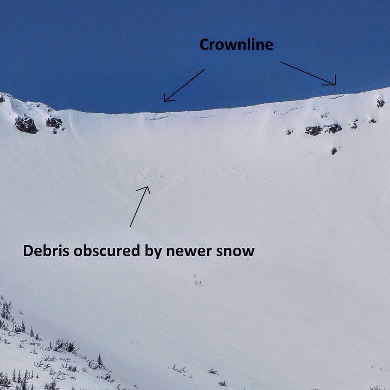
March 18 or 19 soft slab avalanche in Snowslide Canyon Bowl. 3/21 photo, Troy Marino
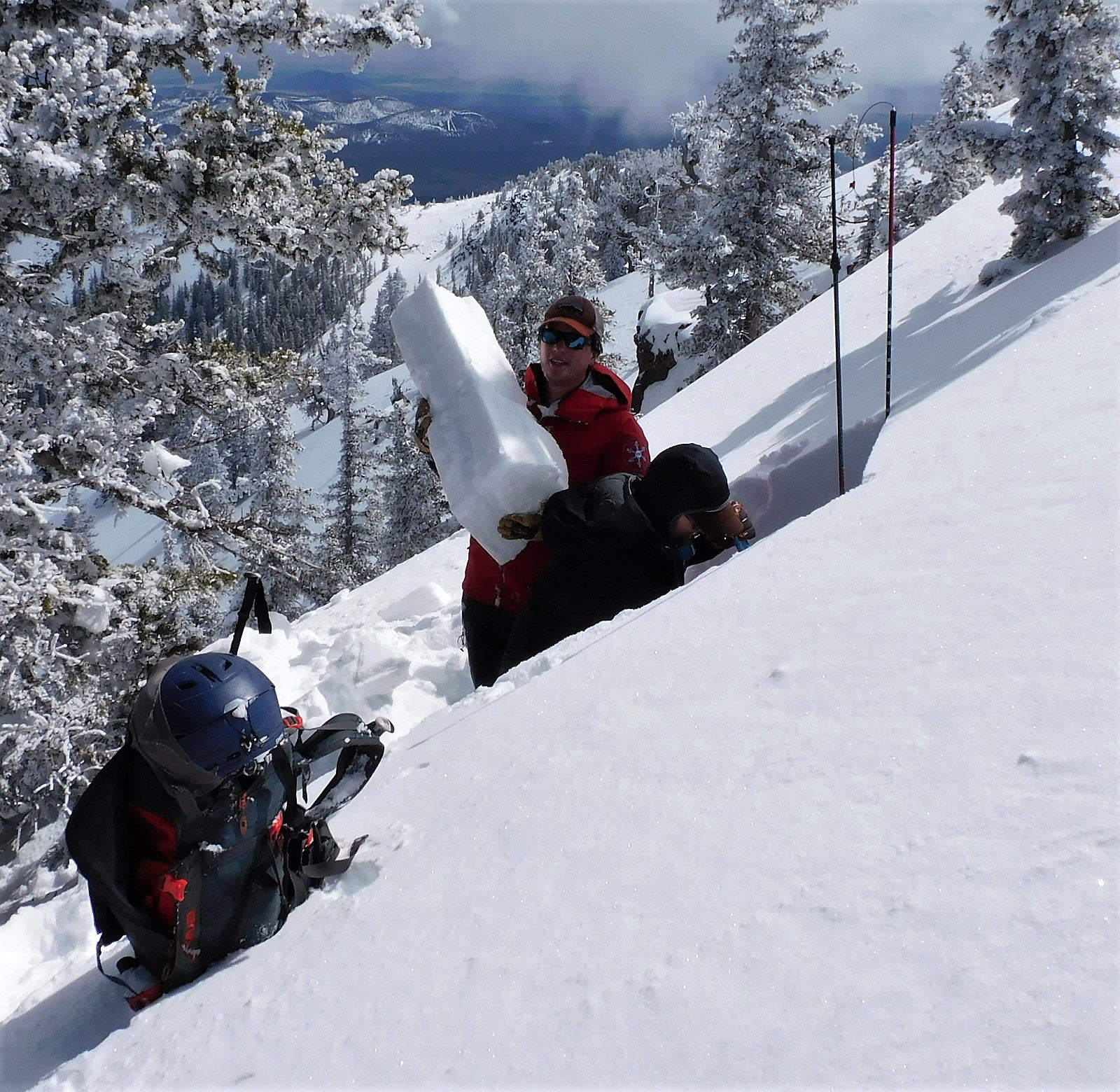
Holding a piece of the persistent slab problem, near the summit of Doyle Peak. 3/20 photo, Troy Marino
Final Thoughts
Always carry the 10 essentials and avalanche rescue gear for wintertime wilderness travel. Submit your observations here. You may save a life!
Weather
The early week storm systems delivered an additional 14” of fresh snow above treeline, and mixed precipitation below treeline caused by fluctuations in the freeze line elevation. This addition brought a total of 40” of snow at 10,800' in the last 10 days. As the system dispersed, moderate to strong winds out of the west brought bluebird post storm conditions to the Peaks, with high potential for transportation of snow above treeline.
This next week brings continued excitement with a cold spell and potential light to moderate precipitation to northern Arizona. A digging low from the north will come to the area Friday through Saturday morning, followed by a trailing short-wave trough. The freeze line will drop to 4,500 feet.
Currently a 10-20% chance of precipitation is in the forecast for early in the workweek. Winds will stay in the moderate range (15-25 mph) out of the west. Temperatures at treeline will climb into the low 40’s F on Tuesday, and a warming trend continuing with spring-like weather.
Arizona Snowbowl is no longer reporting snow depths. Snowbowl ski patrol reported 40" inches of new snow at 10,800 feet since March 19th. Snowslide SNOTEL reports a snow depth of 57" (145cm) at 9,730 feet. So far this winter, 234" (594cm) of snowfall has been reported at 10,800 feet.
Since Friday March 13th, SNOTEL temperatures have ranged between 52° F on March 23rd and 5° F on March 20th. ASBTP station (11,555 ft) is not currently reporting information . Arizona Snowbowl Little Spruce (ASBLS) station (9379’) reported a low of 14° F on March 20th and a high of 31° F on March 22nd and 24th.
Authored/Edited By: Troy Marino, David Lovejoy, Derik Spice
Avalanche Problems/Characters
The avalanche problem/character describes part of the current avalanche danger. However because we only realease a summary once a week, the current avalanche problem will likely change.
Understanding avalanche problems is essential, because it allows you to determine your approach and strategies to risk treatment. Below are brief descriptions of avalanche problems/characters, and links to detailed information on the problem, formation, patterns, recognition, and avoidance strategies.
Avalanche Problems Explained
Also see the North American Danger Scale.
Loose Dry

Release of dry unconsolidated snow. These avalanches typically occur within layers of soft snow near the surface of the snowpack. Loose-dry avalanches start at a point and entrain snow as they move downhill, forming a fan-shaped avalanche. Other names for loose-dry avalanches include point-release avalanches or sluffs. Loose-dry avalanches can trigger slab avalanches that break into deeper snow layers.
Loose Dry avalanches are usually relatively harmless to people. They can be hazardous if you are caught and carried into or over a terrain trap (e.g. gully, rocks, dense timber, cliff, crevasse) or down a long slope. Avoid traveling in or above terrain traps when Loose Dry avalanches are likely. more info
Storm Slab

Release of a soft cohesive layer (a slab) of new snow that breaks within the storm snow or on the old snow surface. Storm-slab problems typically last between a few hours and few days. Storm-slabs that form over a persistent weak layer (surface hoar, depth hoar, or near-surface facets) may be termed Persistent Slabs or may develop into Persistent Slabs.
You can reduce your risk from Storm Slabs by waiting a day or two after a storm before venturing into steep terrain. Storm slabs are most dangerous on slopes with terrain traps, such as timber, gullies, over cliffs, or terrain features that make it difficult for a rider to escape off the side. more info
Wind Slab
Release of a cohesive layer of snow (a slab) formed by the wind. Wind typically transports snow from the upwind sides of terrain features and deposits snow on the downwind side. Wind slabs are often smooth and rounded and sometimes sound hollow, and can range from soft to hard. Wind slabs that form over a persistent weak layer (surface hoar, depth hoar, or near-surface facets) may be termed Persistent Slabs or may develop into Persistent Slabs.
Wind Slabs form in specific areas, and are confined to lee and cross-loaded terrain features. They can be avoided by sticking to sheltered or wind-scoured areas. more info
Persistent Slab
Release of a cohesive layer of soft to hard snow (a slab) in the middle to upper snowpack, when the bond to an underlying persistent weak layer breaks. Persistent layers include: surface hoar, depth hoar, near-surface facets, or faceted snow. Persistent weak layers can continue to produce avalanches for days, weeks or even months, making them especially dangerous and tricky. As additional snow and wind events build a thicker slab on top of the persistent weak layer, this avalanche problem may develop into a Deep Persistent Slab.
The best ways to manage the risk from Persistent Slabs is to make conservative terrain choices. They can be triggered by light loads and weeks after the last storm. The slabs often propagate in surprising and unpredictable ways. This makes this problem difficult to predict and manage and requires a wide safety buffer to handle the uncertainty. more info
Deep Persistent Slab

Release of a thick cohesive layer of hard snow (a slab), when the bond breaks between the slab and an underlying persistent weak layer, deep in the snowpack or near the ground. The most common persistent weak layers involved in deep, persistent slabs are depth hoar or facets surrounding a deeply buried crust. Deep Persistent Slabs are typically hard to trigger, are very destructive and dangerous due to the large mass of snow involved, and can persist for months once developed. They are often triggered from areas where the snow is shallow and weak, and are particularly difficult to forecast for and manage. They commonly develop when Persistent Slabs become more deeply buried over time.
Deep Persistent Slabs are destructive and deadly events that can take months to stabilize. You can trigger them from well down in the avalanche path, and after dozens of tracks have crossed the slope. more info
Loose Wet
Release of wet unconsolidated snow or slush. These avalanches typically occur within layers of wet snow near the surface of the snowpack, but they may quickly gouge into lower snowpack layers. Like Loose Dry Avalanches, they start at a point and entrain snow as they move downhill, forming a fan-shaped avalanche. They generally move slowly, but can contain enough mass to cause significant damage to trees, cars or buildings. Other names for loose-wet avalanches include point-release avalanches or sluffs. Loose Wet avalanches can trigger slab avalanches that break into deeper snow layers.
Travel when the snow surface is colder and stronger. Plan your trips to avoid crossing on or under very steep slopes in the afternoon. Move to colder, shadier slopes once the snow surface turns slushly. Avoid steep, sunlit slopes above terrain traps, cliffs areas and long sustained steep pitches. more info
Wet Slab

Release of a cohesive layer of snow (a slab) that is generally moist or wet when the flow of liquid water weakens the bond between the slab and the surface below (snow or ground). They often occur during prolonged warming events and/or rain-on-snow events. Wet Slabs can be very destructive.
Avoid terrain where and when you suspect Wet Slab avalanche activity. Give yourself a wide safety buffer to handle the uncertainty. more info
Cornice Fall

Cornice Fall is the release of an overhanging mass of snow that forms as the wind moves snow over a sharp terrain feature, such as a ridge, and deposits snow on the downwind (leeward) side. Cornices range in size from small wind lips of soft snow to large overhangs of hard snow that are 30 feet (10 meters) or taller. They can break off the terrain suddenly and pull back onto the ridge top and catch people by surprise even on the flat ground above the slope. Even small cornices can have enough mass to be destructive and deadly. Cornice Fall can entrain loose surface snow or trigger slab avalanches.
Cornices can never be trusted and avoiding them is necessary for safe backcountry travel. Stay well back from ridge line areas with cornices. They often overhang the ridge edge can be triggered remotely. Avoid areas underneath cornices. Even small Cornice Fall can trigger a larger avalanche and large Cornice Fall can easily crush a human. Periods of significant temperature warm-up are times to be particularly aware.
Large cornices are generally rare in Arizona, but they have been observed during very snowy winters. more info
Glide

Release of the entire snow cover as a result of gliding over the ground. Glide avalanches can be composed of wet, moist, or almost entirely dry snow. They typically occur in very specific paths, where the slope is steep enough and the ground surface is relatively smooth. The are often proceeded by full depth cracks (glide cracks), though the time between the appearance of a crack and an avalanche can vary between seconds and months. Glide avalanches are unlikely to be triggered by a person, are nearly impossible to forecast, and thus pose a hazard that is extremely difficult to manage.
Predicting the release of Glide Avalanches is very challenging. Because Glide Avalanches only occur on very specific slopes, safe travel relies on identifying and avoiding those slopes. Glide cracks are a significant indicator, as are recent Glide Avalanches.
Glide avalanches are very uncommon in Arizona. more info
