Snowpack Summary for Friday, April 17, 2020 12:39 PM FINAL SNOWPACK SUMMARY for the 2019/2020 season
This summary expired Apr. 19, 2020 12:39 PM
Flagstaff, Arizona - Backcountry of The San Francisco Peaks and Kachina Peaks Wilderness
For the week ahead, minor weather systems may impact northern Arizona. These will bring variable snow conditions on the Peaks with avalanche problems specific to aspect, elevation and terrain.
Overall, human triggered avalanches are possible, and natural avalanches unlikely. Renewed wind loading and increased temperatures may elevate the hazard level. Problems to watch out for include: wind slabs on upper elevation ridge lines and gullies, wet loose slides on sun affected aspects, and persistent slab on primarily high elevation northern slopes in relation to buried rain and sun crust layers.
In general, the COVID spring conditions are likely to continue to be variable. This season’s snow total is estimated at 257”, just 3” shy of average. Despite depths of over 200cm of snow remaining on upper north facing slopes, lower elevations are likely to have plenty of rotten snow with rocks and logs lurking just below the surface. If you choose to enter the backcountry this spring be aware of changing conditions, and make conservative decisions.
On Tuesday, April 14th, a skier triggered a small R1/D1 soft slab on a 52 degree north facing slope on Fremont, visible from the bottom of Silverton. These problems have mostly stabilized, but continued observations, tests, and conservative travel are warranted, particularly given the current strain on local emergency medical and rescue services
AS a reminder, Snowbowl Road remains closed. Long approaches/egresses to snowy backcountry slopes will be challenging, requiring extra planning, preparedness and effort.
Arizona Snowbowl has suspended all operations, including avalanche hazard mitigation and rescue. Inbound terrain at Arizona Snowbowl is currently closed to all travel.
It bares mentioning that caution in terrain selection and objectives is as important now as it has ever been. It is important to make conservative choices if there is any doubt, as injury in the backcountry may require extensive rescue and medical resources that are already strained in Northern Arizona in the midst of a pandemic. Please consider others in your recreational choices.
Snowpit data
Spring travel strategies
Use caution throughout the day, especially on sunny slopes, as temperatures increase causing the potential for wet/loose avalanches.
During cold temperatures snow may be incredibly firm and require ice axe and crampons. Expect dramatically changing conditions throughout the day. If you are making the long trek into the backcountry, come prepared. Conditions are likely to be highly variable.
Current Problems (noninclusive) more info

Be aware of hollow sounding slabs located on high elevation ridgelines and gullies which could be reactivated by new wind events, especially if accompanied by additional accumulation.
If a backcountry traveler does trigger a wind slab avalanche, it could overwhelm and step down into a deeper persistent weak layer, creating a larger and more destructive avalanche.

The structure of the snowpack remains poor and the possibility of loose wet avalanches and wet slab avalanches will increase during rapid warming, especially right after a storm.
Wet avalanche problems can generally be avoided by skiing earlier in the day and staying off of steeper slopes as temperatures warm up and slush becomes more than a few inches deep.

Additional loading from new precipitation or wind, and/or warming trends could cause this layer to become reactive. Although reactivity has been limited to isolated areas, mostly on north facing slopes, continued awareness and observation of this problem is pertinent to good decision making.
Images
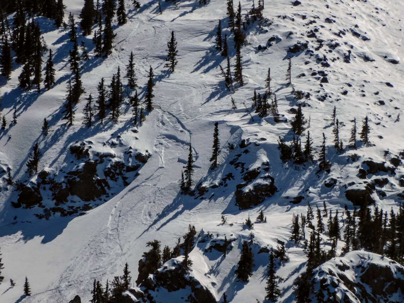
Soft slab triggered by skier on north face of Fremont 4/14/20 (Troy Marino)
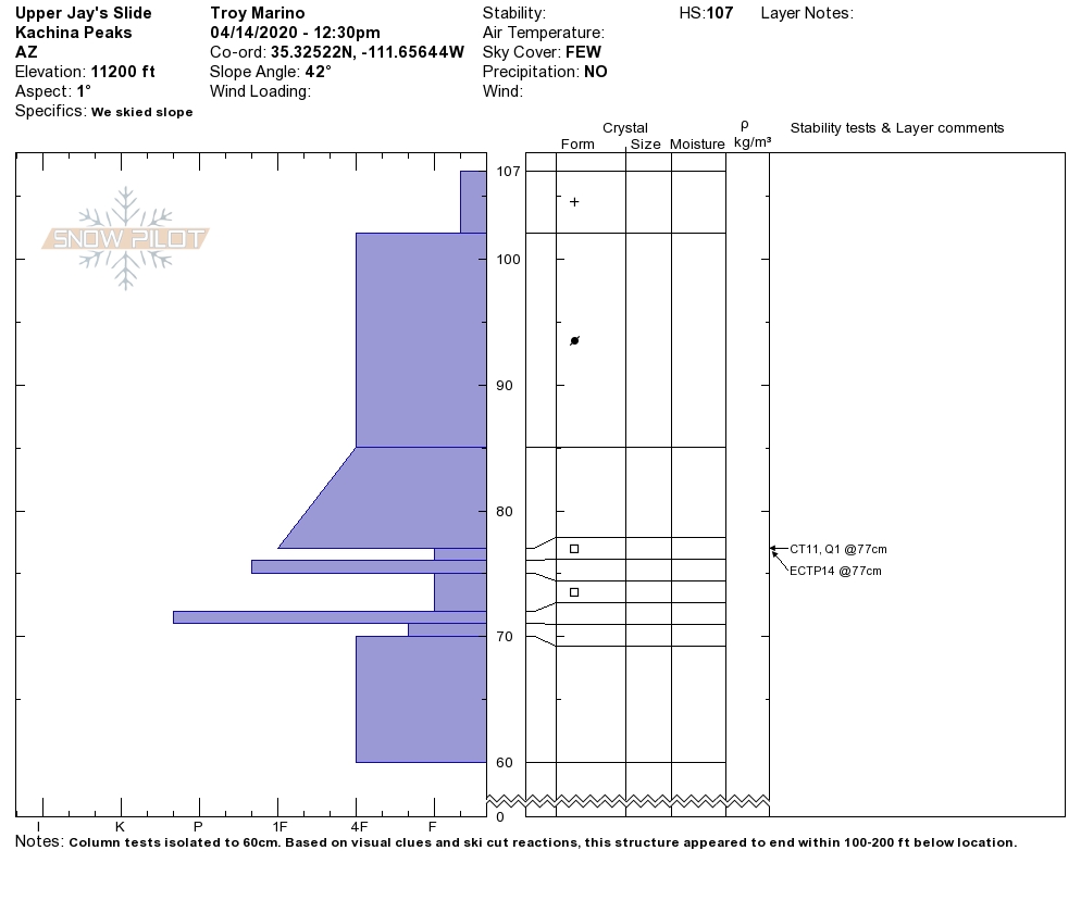
Snowpit profile from 4/14/20 Upper Jay's Slide (Troy Marino)
Final Thoughts
KPAC is dedicated to informing the public of backcountry snow stability conditions, and providing avalanche education to winter enthusiasts. This will be our last scheduled snow summary. Storm updates are possible if conditions warrant.
KPAC would like to thank the winter enthusiasts of Flagstaff and Northern Arizona for your support, and all of our fundraising sponsors.
This was a banner year for KPAC, with 76 avalanche course students and over 40 awarded scholarships. We look forward to fulfilling our mission again for winter 2020-21.
Please continue to submit observations...and be well, and be safe. THANK YOU!
For AZ Snowbowl access updates please refer to https://www.snowbowl.ski and www.flagstaffuphill.com.
Always carry the 10 essentials and avalanche rescue gear for wintertime wilderness travel. Submit your observations here. You may save a life!
Weather
Early in the week 1 to 1.5 feet of new snow fell, with 1.2 to 2 inches of SWE. The storm was followed by strong winds and cool temperatures. Winds were from the west on Monday the 13th, shifting to the northwest and north on Tuesday ranging from 20-30 mph on ridge tops. Spring-like conditions gradually followed the passing of the cold front with breezy afternoons and warming to seasonally normal temperatures rising into the 40s and 50s F.
Saturday April 18th will bring a dry short wave trough to the region. This will feature southwesterly winds and a chance of snow flurries and even thunderstorms, but little accumulation of snow. More settled weather will follow, however, breezy afternoons, typical of our spring conditions, will continue throughout the week. Several potential weather disturbances will pass through over the next week, but these currently appear to be missing northern Arizona, either to the north or south of us.
Since suspension of operations, Arizona Snowbowl is no longer reporting snow depths. Snowslide SNOTEL reports a snow depth of 50" (127cm) at 9,730 feet. So far this winter, 257" (653cm) of snowfall has been reported at 10,800 feet.
Since Friday April 10th SNOTEL temperatures have ranged between 52°F on both April 15th and 16th, and 8°F on April 14th. Arizona Snowbowl Top Patrol (ASBTP) weather station (11,555') is once again reporting. Over the last week, ASBTP reported a low of 11°F on April 14th and a high of 41°F on April 16th.
Authored/Edited By: David Lovejoy, Mathieu Brown, Derik Spice
Avalanche Problems/Characters
The avalanche problem/character describes part of the current avalanche danger. However because we only realease a summary once a week, the current avalanche problem will likely change.
Understanding avalanche problems is essential, because it allows you to determine your approach and strategies to risk treatment. Below are brief descriptions of avalanche problems/characters, and links to detailed information on the problem, formation, patterns, recognition, and avoidance strategies.
Avalanche Problems Explained
Also see the North American Danger Scale.
Loose Dry

Release of dry unconsolidated snow. These avalanches typically occur within layers of soft snow near the surface of the snowpack. Loose-dry avalanches start at a point and entrain snow as they move downhill, forming a fan-shaped avalanche. Other names for loose-dry avalanches include point-release avalanches or sluffs. Loose-dry avalanches can trigger slab avalanches that break into deeper snow layers.
Loose Dry avalanches are usually relatively harmless to people. They can be hazardous if you are caught and carried into or over a terrain trap (e.g. gully, rocks, dense timber, cliff, crevasse) or down a long slope. Avoid traveling in or above terrain traps when Loose Dry avalanches are likely. more info
Storm Slab

Release of a soft cohesive layer (a slab) of new snow that breaks within the storm snow or on the old snow surface. Storm-slab problems typically last between a few hours and few days. Storm-slabs that form over a persistent weak layer (surface hoar, depth hoar, or near-surface facets) may be termed Persistent Slabs or may develop into Persistent Slabs.
You can reduce your risk from Storm Slabs by waiting a day or two after a storm before venturing into steep terrain. Storm slabs are most dangerous on slopes with terrain traps, such as timber, gullies, over cliffs, or terrain features that make it difficult for a rider to escape off the side. more info
Wind Slab
Release of a cohesive layer of snow (a slab) formed by the wind. Wind typically transports snow from the upwind sides of terrain features and deposits snow on the downwind side. Wind slabs are often smooth and rounded and sometimes sound hollow, and can range from soft to hard. Wind slabs that form over a persistent weak layer (surface hoar, depth hoar, or near-surface facets) may be termed Persistent Slabs or may develop into Persistent Slabs.
Wind Slabs form in specific areas, and are confined to lee and cross-loaded terrain features. They can be avoided by sticking to sheltered or wind-scoured areas. more info
Persistent Slab
Release of a cohesive layer of soft to hard snow (a slab) in the middle to upper snowpack, when the bond to an underlying persistent weak layer breaks. Persistent layers include: surface hoar, depth hoar, near-surface facets, or faceted snow. Persistent weak layers can continue to produce avalanches for days, weeks or even months, making them especially dangerous and tricky. As additional snow and wind events build a thicker slab on top of the persistent weak layer, this avalanche problem may develop into a Deep Persistent Slab.
The best ways to manage the risk from Persistent Slabs is to make conservative terrain choices. They can be triggered by light loads and weeks after the last storm. The slabs often propagate in surprising and unpredictable ways. This makes this problem difficult to predict and manage and requires a wide safety buffer to handle the uncertainty. more info
Deep Persistent Slab

Release of a thick cohesive layer of hard snow (a slab), when the bond breaks between the slab and an underlying persistent weak layer, deep in the snowpack or near the ground. The most common persistent weak layers involved in deep, persistent slabs are depth hoar or facets surrounding a deeply buried crust. Deep Persistent Slabs are typically hard to trigger, are very destructive and dangerous due to the large mass of snow involved, and can persist for months once developed. They are often triggered from areas where the snow is shallow and weak, and are particularly difficult to forecast for and manage. They commonly develop when Persistent Slabs become more deeply buried over time.
Deep Persistent Slabs are destructive and deadly events that can take months to stabilize. You can trigger them from well down in the avalanche path, and after dozens of tracks have crossed the slope. more info
Loose Wet
Release of wet unconsolidated snow or slush. These avalanches typically occur within layers of wet snow near the surface of the snowpack, but they may quickly gouge into lower snowpack layers. Like Loose Dry Avalanches, they start at a point and entrain snow as they move downhill, forming a fan-shaped avalanche. They generally move slowly, but can contain enough mass to cause significant damage to trees, cars or buildings. Other names for loose-wet avalanches include point-release avalanches or sluffs. Loose Wet avalanches can trigger slab avalanches that break into deeper snow layers.
Travel when the snow surface is colder and stronger. Plan your trips to avoid crossing on or under very steep slopes in the afternoon. Move to colder, shadier slopes once the snow surface turns slushly. Avoid steep, sunlit slopes above terrain traps, cliffs areas and long sustained steep pitches. more info
Wet Slab

Release of a cohesive layer of snow (a slab) that is generally moist or wet when the flow of liquid water weakens the bond between the slab and the surface below (snow or ground). They often occur during prolonged warming events and/or rain-on-snow events. Wet Slabs can be very destructive.
Avoid terrain where and when you suspect Wet Slab avalanche activity. Give yourself a wide safety buffer to handle the uncertainty. more info
Cornice Fall

Cornice Fall is the release of an overhanging mass of snow that forms as the wind moves snow over a sharp terrain feature, such as a ridge, and deposits snow on the downwind (leeward) side. Cornices range in size from small wind lips of soft snow to large overhangs of hard snow that are 30 feet (10 meters) or taller. They can break off the terrain suddenly and pull back onto the ridge top and catch people by surprise even on the flat ground above the slope. Even small cornices can have enough mass to be destructive and deadly. Cornice Fall can entrain loose surface snow or trigger slab avalanches.
Cornices can never be trusted and avoiding them is necessary for safe backcountry travel. Stay well back from ridge line areas with cornices. They often overhang the ridge edge can be triggered remotely. Avoid areas underneath cornices. Even small Cornice Fall can trigger a larger avalanche and large Cornice Fall can easily crush a human. Periods of significant temperature warm-up are times to be particularly aware.
Large cornices are generally rare in Arizona, but they have been observed during very snowy winters. more info
Glide

Release of the entire snow cover as a result of gliding over the ground. Glide avalanches can be composed of wet, moist, or almost entirely dry snow. They typically occur in very specific paths, where the slope is steep enough and the ground surface is relatively smooth. The are often proceeded by full depth cracks (glide cracks), though the time between the appearance of a crack and an avalanche can vary between seconds and months. Glide avalanches are unlikely to be triggered by a person, are nearly impossible to forecast, and thus pose a hazard that is extremely difficult to manage.
Predicting the release of Glide Avalanches is very challenging. Because Glide Avalanches only occur on very specific slopes, safe travel relies on identifying and avoiding those slopes. Glide cracks are a significant indicator, as are recent Glide Avalanches.
Glide avalanches are very uncommon in Arizona. more info
