kpac home
  • Home
  • Snowpack
    • Get The Forecast
    • Alerts Sign-up
    • Historic Snowpack Summary Archive
    • Observations
    • Submit Observation
    • Snowpack Data (snowpilot.org)
    • KPAC Backcountry Group
    • RAC Project
  • Weather
    • NWS Flagstaff Area Forecast Discussion
    • NWS Treeline Forecast (~11,500')
    • NWS Near Treeline Forecast (~10,900')
    • NWS Below Treeline Forecast (~10,000')
    • GFS Model Guidance
    • NBM Model Guidance
    • Precipitation Analysis
    • GOES (satellite) Image Viewer
    • AZ Snowbowl Top Patrol (ASBTP)
    • AZ Snowbowl Top of Grand Canyon Express Lift (AU373)
    • AZ Snowbowl Primary Pump House (ASBSB)
    • AZ Snowbowl Little Spruce Station (ASBLS)
    • Snowslide Canyon SNOTEL - 7 day summary
    • Snowslide Canyon SNOTEL - 72 hour summary
    • Snowslide Canyon SNOTEL - 72 hour time series viewer
    • Snowslide Canyon SNOTEL - current water year plot
    • SNOTEL - Station/Basin Status Map
    • Flagstaff Airport Station
    • Flagstaff Alert Data (JEFDAQ)
    • Holfuy Stations
    • Snowbowl Webcams
    • NAU Webcam
    • NWS Peaks Webcam
  • Education
    • KPAC Courses
    • Scholarship Information
    • Free Online Avalanche Awareness Course
    • Avalanche.org Avalanche Basics
    • Rescue at Cherry Bowl
    • Avalanche at Tunnel Creek
    • Snow Avalanches on the San Francisco Peaks
    • Avalanches in Arizona?
    • Avalanche Awareness in the Kachina Peaks Wilderness (youtube)
    • Know Before You Go (kbyg.org)
  • Resources
    • Snow, Weather, and Avalanches observational Guidelines (SWAG)
    • Maps
    • Forest Roads Status (fs.usda.gov)
    • ADOT Travel Alerts (az511.com)
    • KPAC Logos
  • About
    • Mission
    • Donate/Sponsor
    • Newsletter
    • Team
    • Contact
    • Bylaws

Snowpack Summary for Friday, January 28, 2022 1:56 PM 5″ of Precipitation Last Weekend, and Winds Continue

This summary expired Jan. 30, 2022 1:56 PM

Flagstaff, Arizona - Backcountry of The San Francisco Peaks and Kachina Peaks Wilderness

Disclaimer

Format and Limitations Statement

Newsletter

This summary is generously sponsored by onX Backcountry. The ultimate GPS navigation app for your outdoor pursuits. Use promo code KACHINA20 for a 20% discount!
onX Backcountry
Overall Human triggered avalanches are possible where new wind slabs formed.
Between Jan. 19 and 23, eight inches of low density snow accumulated near 10800'. In some locations this snow did not bond well with hard layers below (see small loose point and slab release photo below). These small releases may continue as temperatures warm on Saturday. It's also possible that the Thursday night wind storm stripped away much of the soft surface snow.
On Sunday, Jan. 23 a very small (R1D1) human triggered avalanche was reported on a northerly aspect of Hardcore Ridge, near and below treeline. Nearby, noticeable under ski cracking and loose snow sluffing was also reported. While not enough snow to bury a person, they could cause problems if knocking a person off their feet in extreme terrain.
Using SNOTEL data since it went online (1997-09-01), we are close to 100% for snow depth and snow water equivalent for late January (see graph below).
Soft surface snow has undergone near surface faceting over the last few days. This has provided good powder skiing this week, but may become a failure point with new significant accumulation or wind loading.
Unfortunately, early season conditions persist and recreationists should remain cautious of obvious and partially buried obstacles.
Only very small (R1D1) human and natural avalanches reported this season.
Depth hoar and basal facets can be found primarily on slopes above 10,500'. Recent instability test results on northly and westerly slopes have not revealed any significant weaknesses in these layers.
Recent snowpit data may be found at snowpit.org.

Note that we have changed the format of our elevation sections to Near and Above Treeline (~10,800' and above) and Below Treeline (~below 10,800'). We did this for two reasons: first to be specific; and two, most of the San Francisco Peaks avalanche starting-zones lie above 10'800, and in general the weather is similar between 10,800' and the highest point of 12,633'.
Near and Above Treeline (~10,800' and above)Powerful northerly and easterly winds (up to 68 mph) blew at treeline last night and this morning. Yesterday near 11,200' on Fremont Peak, an east-northeasterly starting zone was actively cross loading from a moderate north wind.
It's possible that the Thursday night wind storm stripped away and sublimated much of the soft surface snow.
In general, the wind of the last two weeks has distributed snow across the San Francisco Peaks in highly variable ways. Some slopes have deep deposits of hard wind blown snow, while other areas have been stripped leaving loose, rocky terrain.
Crampons and ice axe will be helpful on steep hard snow.
Below Treeline (~below 10,800')Keep an eye open for unstable snow in isolated areas or extreme terrain. Watch for roller balls and wet destabilizing snow on sunny and southerly aspects as temperatures approach 40°F near 10,000' tomorrow, January 29. Cooler weather after Saturday should mitigate this problem.
Thin coverage, rocks, and logs will make approaches and egresses challenging, particularly below 10,500' on southerly aspects. Northerly aspects still have good coverage down to ~9000'.

Current Problems (noninclusive) more info

Wind Slab
problem 1
Isolated pockets of new wind formed slab will be possible above ~10,800'. Strong northerly and easterly winds may have loaded southerly and westerly slopes. Isolated gullies and chutes on other aspects may have new slabs created by cross loading.

Images

image

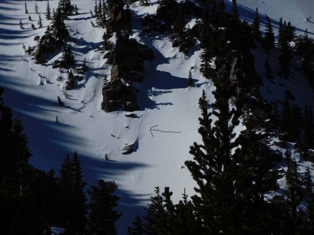
Small loose point release on ENE aspect of Fremont Peak. Appears to have triggered a very small slab. January 27 photo from Troy Marino.

expand image
image

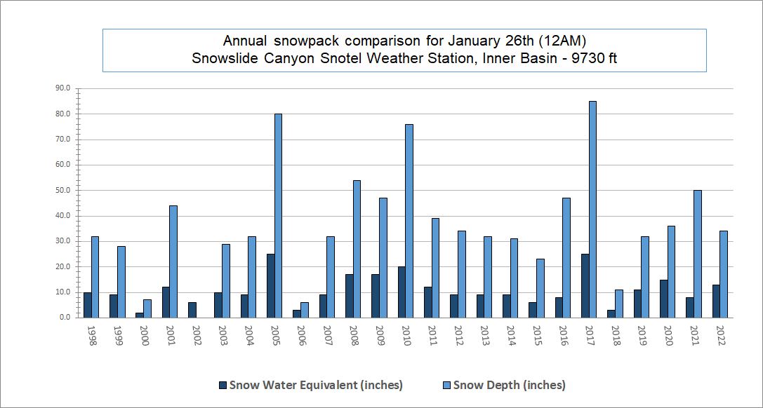
January 26th comparison, using Snowslide SNOTEL data since it went online (1997-09-01). Snow water equivalent is 13" (117%) and snow depth is 34" (89%).

expand image

Final Thoughts

Always carry the 10 essentials and avalanche rescue gear for wintertime wilderness travel. Submit your observations here.
For AZ Snowbowl uphill access updates please refer to snowbowl.ski and flagstaffuphill.com. The Kachina Peaks wilderness is accessible from the lower parking lots at Snowbowl.

Weather

Weather updated Friday January 28
Between Friday afternoon and Sunday morning (January 21-23), a weak cutoff low had just enough energy and moisture for 5" of accumulation near 10,800'. For that same time-period, Snowslide SNOTEL reported ~0.3" of snow water equivalent added to the snowpack.
Tuesday, January 25 had northerly moderate winds, and moderate to strong northeasterly winds blew on January 26. Powerful northerly and easterly winds (up to 68 mph) blew at treeline on January 27 and 28. Temperatures were seasonably cool this past week.
Expect lighter winds today and over the weekend, along with light flurries on Sunday. Temperatures will push 40°F near 10,000' on Saturday, Jan. 29. Another sharp cold front is due next Tuesday.

So far this winter, we have had a total of 86" (218 cm) of snowfall at 10,800' with a 50" (127 cm) undisturbed settled base depth reported by Arizona Snowbowl on January 28.
Since January 21, Snowslide SNOTEL low temperatures have ranged between 2°F on January 26 and 22°F on January 24, while highs have ranged from 25°F on January 22 and 20 to 42°F on January 24. For the same time period, ASTP station (11,555') reports a low of 8°F on January 26 and a high of 41°F on January 24.
Weather Links

Authored/Edited By: Troy Marino, Derik Spice

Avalanche Problems/Characters

The avalanche problem/character describes part of the current avalanche danger. However because we only realease a summary once a week, the current avalanche problem will likely change. Understanding avalanche problems is essential, because it allows you to determine your approach and strategies to risk treatment. Below are brief descriptions of avalanche problems/characters, and links to detailed information on the problem, formation, patterns, recognition, and avoidance strategies.
Avalanche Problems Explained
Also see the North American Danger Scale.

Loose Dry

Loose Dry

Release of dry unconsolidated snow. These avalanches typically occur within layers of soft snow near the surface of the snowpack. Loose-dry avalanches start at a point and entrain snow as they move downhill, forming a fan-shaped avalanche. Other names for loose-dry avalanches include point-release avalanches or sluffs. Loose-dry avalanches can trigger slab avalanches that break into deeper snow layers.

Loose Dry avalanches are usually relatively harmless to people. They can be hazardous if you are caught and carried into or over a terrain trap (e.g. gully, rocks, dense timber, cliff, crevasse) or down a long slope. Avoid traveling in or above terrain traps when Loose Dry avalanches are likely. more info

Storm Slab

Storm Slab

Release of a soft cohesive layer (a slab) of new snow that breaks within the storm snow or on the old snow surface. Storm-slab problems typically last between a few hours and few days. Storm-slabs that form over a persistent weak layer (surface hoar, depth hoar, or near-surface facets) may be termed Persistent Slabs or may develop into Persistent Slabs.

You can reduce your risk from Storm Slabs by waiting a day or two after a storm before venturing into steep terrain. Storm slabs are most dangerous on slopes with terrain traps, such as timber, gullies, over cliffs, or terrain features that make it difficult for a rider to escape off the side. more info

Wind Slab

Wind Slab

Release of a cohesive layer of snow (a slab) formed by the wind. Wind typically transports snow from the upwind sides of terrain features and deposits snow on the downwind side. Wind slabs are often smooth and rounded and sometimes sound hollow, and can range from soft to hard. Wind slabs that form over a persistent weak layer (surface hoar, depth hoar, or near-surface facets) may be termed Persistent Slabs or may develop into Persistent Slabs.

Wind Slabs form in specific areas, and are confined to lee and cross-loaded terrain features. They can be avoided by sticking to sheltered or wind-scoured areas. more info

Persistent Slab

Persistent Slab

Release of a cohesive layer of soft to hard snow (a slab) in the middle to upper snowpack, when the bond to an underlying persistent weak layer breaks. Persistent layers include: surface hoar, depth hoar, near-surface facets, or faceted snow. Persistent weak layers can continue to produce avalanches for days, weeks or even months, making them especially dangerous and tricky. As additional snow and wind events build a thicker slab on top of the persistent weak layer, this avalanche problem may develop into a Deep Persistent Slab.

The best ways to manage the risk from Persistent Slabs is to make conservative terrain choices. They can be triggered by light loads and weeks after the last storm. The slabs often propagate in surprising and unpredictable ways. This makes this problem difficult to predict and manage and requires a wide safety buffer to handle the uncertainty. more info

Deep Persistent Slab

Deep Persistent Slab

Release of a thick cohesive layer of hard snow (a slab), when the bond breaks between the slab and an underlying persistent weak layer, deep in the snowpack or near the ground. The most common persistent weak layers involved in deep, persistent slabs are depth hoar or facets surrounding a deeply buried crust. Deep Persistent Slabs are typically hard to trigger, are very destructive and dangerous due to the large mass of snow involved, and can persist for months once developed. They are often triggered from areas where the snow is shallow and weak, and are particularly difficult to forecast for and manage. They commonly develop when Persistent Slabs become more deeply buried over time.

Deep Persistent Slabs are destructive and deadly events that can take months to stabilize. You can trigger them from well down in the avalanche path, and after dozens of tracks have crossed the slope. more info

Loose Wet

Loose Wet

Release of wet unconsolidated snow or slush. These avalanches typically occur within layers of wet snow near the surface of the snowpack, but they may quickly gouge into lower snowpack layers. Like Loose Dry Avalanches, they start at a point and entrain snow as they move downhill, forming a fan-shaped avalanche. They generally move slowly, but can contain enough mass to cause significant damage to trees, cars or buildings. Other names for loose-wet avalanches include point-release avalanches or sluffs. Loose Wet avalanches can trigger slab avalanches that break into deeper snow layers.

Travel when the snow surface is colder and stronger. Plan your trips to avoid crossing on or under very steep slopes in the afternoon. Move to colder, shadier slopes once the snow surface turns slushly. Avoid steep, sunlit slopes above terrain traps, cliffs areas and long sustained steep pitches. more info

Wet Slab

Wet Slab

Release of a cohesive layer of snow (a slab) that is generally moist or wet when the flow of liquid water weakens the bond between the slab and the surface below (snow or ground). They often occur during prolonged warming events and/or rain-on-snow events. Wet Slabs can be very destructive.

Avoid terrain where and when you suspect Wet Slab avalanche activity. Give yourself a wide safety buffer to handle the uncertainty. more info

Cornice Fall

Cornice Fall

Cornice Fall is the release of an overhanging mass of snow that forms as the wind moves snow over a sharp terrain feature, such as a ridge, and deposits snow on the downwind (leeward) side. Cornices range in size from small wind lips of soft snow to large overhangs of hard snow that are 30 feet (10 meters) or taller. They can break off the terrain suddenly and pull back onto the ridge top and catch people by surprise even on the flat ground above the slope. Even small cornices can have enough mass to be destructive and deadly. Cornice Fall can entrain loose surface snow or trigger slab avalanches.

Cornices can never be trusted and avoiding them is necessary for safe backcountry travel. Stay well back from ridge line areas with cornices. They often overhang the ridge edge can be triggered remotely. Avoid areas underneath cornices. Even small Cornice Fall can trigger a larger avalanche and large Cornice Fall can easily crush a human. Periods of significant temperature warm-up are times to be particularly aware.

Large cornices are generally rare in Arizona, but they have been observed during very snowy winters. more info

Glide

Glide

Release of the entire snow cover as a result of gliding over the ground. Glide avalanches can be composed of wet, moist, or almost entirely dry snow. They typically occur in very specific paths, where the slope is steep enough and the ground surface is relatively smooth. The are often proceeded by full depth cracks (glide cracks), though the time between the appearance of a crack and an avalanche can vary between seconds and months. Glide avalanches are unlikely to be triggered by a person, are nearly impossible to forecast, and thus pose a hazard that is extremely difficult to manage.

Predicting the release of Glide Avalanches is very challenging. Because Glide Avalanches only occur on very specific slopes, safe travel relies on identifying and avoiding those slopes. Glide cracks are a significant indicator, as are recent Glide Avalanches.

Glide avalanches are very uncommon in Arizona. more info

Snowpack Summary Disclaimer

The summaries on this site were written by Kachina Peaks Avalanche Center Board Members. They are based on a broad spectrum of data collected from weather stations, National Weather Service point forecasts and field observation by qualified individuals.

The summaries are not intended to substitute for good knowledge and decision making skills in avalanche terrain. If you have any doubt of stable conditions, please stay away from avalanche terrain. You can usually find good places to go that are not prone to avalanches, such as on low angle slopes away from avalanche run-out zones. If you have any questions about where to find such places, you should consider further avalanche educational opportunities, such as those listed on our education page.

Snowpack Summary – Format and Limitations Statement

Starting in 2012 Kachina Peaks Avalanche Center (KPAC) has publish a weekly Snowpack Summary on our website. These summaries are currently issued on Friday afternoons. On occasion, we will give storm updates or warnings of rapidly increasing avalanche hazard at more frequent intervals. Our objective is to reach weekend recreationist, informing this user group of prevailing conditions, but particularly warning of avalanche hazards whenever they are present. Many people have asked us why we use the format we do, but do not include a danger rating or a hazard/stability rose as many other avalanche centers do around the west.

The National Avalanche Center (NAC) advises small operations like KPAC, who do not issue daily bulletins to not use danger ratings in our snowpack summaries due to the regular but intermittent nature of their field observations and the length of time between issuance of snowpack summaries. A primary concern is for how conditions can change in the time between publications, potentially giving the public misleading information. At this point, we simply do not have resources to monitor the snowpack at the level necessary to accurately produce more frequent bulletins. While we understand the benefits of a danger rating using the North American Danger Scale, we also feel that our format encourages people to dig in a little deeper, and spend some time reading what our forecasters are saying. Although the area that we forecast is relatively small, the variability has proven quite large. Inner Basin conditions are often surprisingly different from those on the more wind-affected western side on the Peaks.

We hope the information that we provide in summaries helps give you a good overview of what is going on out there, and what avalanche problems you should be attentive to, but if there is any uncertainty, then we encourage you to ask questions via Facebook or info@kachinapeaks.org.

Submit an Observation

sponsors

facebook/kachinapeaksavy

instagram/kachinapeaksavy
  • Home
  • Get The Forecast
  • Submit Observation
  • Courses
  • Alerts
  • Newsletter
  • Mission
  • Donate/Sponsor
  • Contact

KPAC is authorized to operate on the Coconino National Forest under a Special Use Permit

© 2025 Kachina Peaks Avalanche Center - KPAC