kpac home
  • Home
  • Snowpack
    • Get The Forecast
    • Alerts Sign-up
    • Historic Snowpack Summary Archive
    • Observations
    • Submit Observation
    • Snowpack Data (snowpilot.org)
    • KPAC Backcountry Group
    • RAC Project
  • Weather
    • NWS Flagstaff Area Forecast Discussion
    • NWS Treeline Forecast (~11,500')
    • NWS Near Treeline Forecast (~10,900')
    • NWS Below Treeline Forecast (~10,000')
    • GFS Model Guidance
    • NBM Model Guidance
    • Precipitation Analysis
    • GOES (satellite) Image Viewer
    • AZ Snowbowl Top Patrol (ASBTP)
    • AZ Snowbowl Top of Grand Canyon Express Lift (AU373)
    • AZ Snowbowl Primary Pump House (ASBSB)
    • AZ Snowbowl Little Spruce Station (ASBLS)
    • Snowslide Canyon SNOTEL - 7 day summary
    • Snowslide Canyon SNOTEL - 72 hour summary
    • Snowslide Canyon SNOTEL - 72 hour time series viewer
    • Snowslide Canyon SNOTEL - current water year plot
    • SNOTEL - Station/Basin Status Map
    • Flagstaff Airport Station
    • Flagstaff Alert Data (JEFDAQ)
    • Holfuy Stations
    • Snowbowl Webcams
    • NAU Webcam
    • NWS Peaks Webcam
  • Education
    • KPAC Courses
    • Scholarship Information
    • Free Online Avalanche Awareness Course
    • Avalanche.org Avalanche Basics
    • Rescue at Cherry Bowl
    • Avalanche at Tunnel Creek
    • Snow Avalanches on the San Francisco Peaks
    • Avalanches in Arizona?
    • Avalanche Awareness in the Kachina Peaks Wilderness (youtube)
    • Know Before You Go (kbyg.org)
  • Resources
    • Snow, Weather, and Avalanches observational Guidelines (SWAG)
    • Maps
    • Forest Roads Status (fs.usda.gov)
    • ADOT Travel Alerts (az511.com)
    • KPAC Logos
  • About
    • Mission
    • Donate/Sponsor
    • Newsletter
    • Team
    • Contact
    • Bylaws

Snowpack Summary for Friday, March 11, 2022 4:22 PM Winds on Friday reorganize new storm snow.

This summary expired Mar. 13, 2022 4:22 PM

Flagstaff, Arizona - Backcountry of The San Francisco Peaks and Kachina Peaks Wilderness

Disclaimer

Format and Limitations Statement

Newsletter

This summary is generously sponsored by Spark R&D. We are raffling a pair of Spark R&D Splitboard Bindings. Size of your choosing! All proceeds to support the Mikee Linville Backcountry Scholarship. Click Spark R&D logo below for raffle link.
Spark R&D
Overall High winds dominate the weather pattern heading into the weekend and have likely loaded specific aspects while stripping others. With the 10"-18" of new snow over the last 24 hours and 49" in the last week there is plenty available for transport, however winds may have sent much of the above treeline snow into the atmosphere.
In summation natural avalanches are unlikely while human triggered avalanches are possible on wind loaded slopes. Watch out for stiff, reactive snow in the starting zones of the peaks and puffy slopes and rollovers. Observers have not made it above tree line since Wednesday before the new snow and wind event and therefore uncertainty is high and observations are welcome from the public.
Thin snowpack conditions are present on many southeast through southwest slopes, and 10"-18" of light new snow has obscured the many hazards lurking beneath the surface. Travel in these areas will require caution as new snow will be lying directly on mostly rock and dirt, and thus travelers should be cautious of obstacles buried just beneath the new snow.
Snowpit data may be found at snowpit.org.
Near and Above Treeline (~10,800' and above)Conditions near and above treeline are expected to be highly variable. Wind has blown from almost every direction during the last 24 hours. Mountain travelers should avoid areas of wind loading and watch for shooting cracks and whoomphs. Carefully evaluate starting zones before committing to avalanche terrain.
Facets remain on steep north through east facing slopes between roughly 10,400' and 11,500' and may be reinvigorated by snow loading from this recent storm. Specifically, a layer of facets has developed under approximately 4" of mid-February snow. In some areas these facets may be associated with a melt-freeze crust. This weak layer poses a concern for persistent slab avalanche releases.
Recreationists are encouraged to examine snowpack structure and test for signs of instability. In a few locations weak basal facets have been found, but these are not thought to be widely distributed. Be aware of their possible presence on cold north facing slopes. Failure at this layer may result in avalanches propagating at the very bottom of the snowpack.
Below Treeline (~below 10,800')Below treeline, both windslab and persistent slab could be still be present. Although trees provide protection, windslabs, particularly at rollovers and in small steep clearings, are possible. The persistent slab problem has been observed as low as 10,400' and cold northly aspects should still be treated with suspicion.
New snow will hide rocks and logs on southern, western and possibly east aspects. Cautious travel is recommended. On north aspects more snow should provide adequate travel opportunities down to approximately 8,500 feet.

Current Problems (noninclusive) more info

Wind Slab
problem 1
Watch for newly formed wind slabs on leeward slopes and cross-loaded terrain features. Observe for shooting cracks and the feel of hollow snow while contouring slopes and traversing ridgelines.
Persistent Slab
problem 2
Persistent slab problems on northly, northeasterly and easterly slopes between 10,400' and 11,500' may be activated by wind or new snow loading. Facets lurking below the mid-February layer are of concern in these areas. See image in previous summary. https://kachinapeaks.org/Snowpack/2022/3/4

There may also be a crust associated with this persistent problem.

Images

image

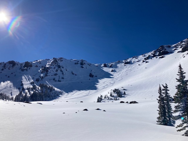
Humphreys Cirque 03/08/2022
A popular day in the backcountry. Photo credit Blair Foust.

expand image
image

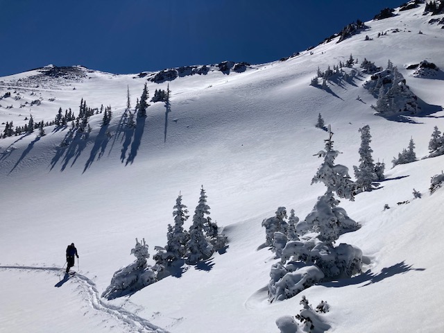
Snowslide Canyon 03/08/2022. Photo credit Blair Foust.

expand image

Final Thoughts

We couldn't do this with out your support! The KPAC Mikee Linville Fundraiser returns to the Arizona Snowbowl April 2nd.
Food, music, raffle, skiing and Friends on the Agassiz Deck.
Always carry the 10 essentials and avalanche rescue gear for wintertime wilderness travel. Submit your observations here.
For AZ Snowbowl uphill access updates please refer to snowbowl.ski and flagstaffuphill.com. The Kachina Peaks wilderness is accessible from the lower parking lots at Snowbowl.

Weather

Weather updated Friday March 11 - David Lovejoy
A series of three storms, which arrived last weekend and extended until Tuesday March 8, delivered a total of 31” of snowfall at 10,800 feet. Another quick moving short wave low breezed through on Thursday March 10, adding another 18“ of high elevation snow. Throughout the week, prevailing storm winds were southwesterly, shifting to northerly between precipitation events. Extreme north winds are forecast for Friday afternoon March 11, averaging 40-50 mph and gusting to 75 mph. Blowing snow was observed throughout the past week.
Looking forward, high pressure appears to be building, however, fair weather will continue to be periodically interrupted by glancing blows from short wave lows, with the customary cooler than average temperatures, blustery southwest winds and the possibility of light snowfall.
One such event will arrive on Wednesday March 16, but is currently not expected to add significant precipitation to the region.
So far this winter, we have had a total of 168” (427 cm) of snowfall at 10,800' with a 71" (180 cm) undisturbed settled base depth. This put us at 70% of average annual snowfall. Since March 4,
Snowslide SNOTEL low temperatures have ranged between -3°F on March 8 and 23° F on March 4, while highs have ranged from 26°F on March 5 to 36° F on March 8. For the same time period, ASTP station (11,555') reports a low of 2°F on March 8 and a high of 27°F on March 8.
Weather Links

Authored/Edited By: Blair Foust, Derik Spice

Avalanche Problems/Characters

The avalanche problem/character describes part of the current avalanche danger. However because we only realease a summary once a week, the current avalanche problem will likely change. Understanding avalanche problems is essential, because it allows you to determine your approach and strategies to risk treatment. Below are brief descriptions of avalanche problems/characters, and links to detailed information on the problem, formation, patterns, recognition, and avoidance strategies.
Avalanche Problems Explained
Also see the North American Danger Scale.

Loose Dry

Loose Dry

Release of dry unconsolidated snow. These avalanches typically occur within layers of soft snow near the surface of the snowpack. Loose-dry avalanches start at a point and entrain snow as they move downhill, forming a fan-shaped avalanche. Other names for loose-dry avalanches include point-release avalanches or sluffs. Loose-dry avalanches can trigger slab avalanches that break into deeper snow layers.

Loose Dry avalanches are usually relatively harmless to people. They can be hazardous if you are caught and carried into or over a terrain trap (e.g. gully, rocks, dense timber, cliff, crevasse) or down a long slope. Avoid traveling in or above terrain traps when Loose Dry avalanches are likely. more info

Storm Slab

Storm Slab

Release of a soft cohesive layer (a slab) of new snow that breaks within the storm snow or on the old snow surface. Storm-slab problems typically last between a few hours and few days. Storm-slabs that form over a persistent weak layer (surface hoar, depth hoar, or near-surface facets) may be termed Persistent Slabs or may develop into Persistent Slabs.

You can reduce your risk from Storm Slabs by waiting a day or two after a storm before venturing into steep terrain. Storm slabs are most dangerous on slopes with terrain traps, such as timber, gullies, over cliffs, or terrain features that make it difficult for a rider to escape off the side. more info

Wind Slab

Wind Slab

Release of a cohesive layer of snow (a slab) formed by the wind. Wind typically transports snow from the upwind sides of terrain features and deposits snow on the downwind side. Wind slabs are often smooth and rounded and sometimes sound hollow, and can range from soft to hard. Wind slabs that form over a persistent weak layer (surface hoar, depth hoar, or near-surface facets) may be termed Persistent Slabs or may develop into Persistent Slabs.

Wind Slabs form in specific areas, and are confined to lee and cross-loaded terrain features. They can be avoided by sticking to sheltered or wind-scoured areas. more info

Persistent Slab

Persistent Slab

Release of a cohesive layer of soft to hard snow (a slab) in the middle to upper snowpack, when the bond to an underlying persistent weak layer breaks. Persistent layers include: surface hoar, depth hoar, near-surface facets, or faceted snow. Persistent weak layers can continue to produce avalanches for days, weeks or even months, making them especially dangerous and tricky. As additional snow and wind events build a thicker slab on top of the persistent weak layer, this avalanche problem may develop into a Deep Persistent Slab.

The best ways to manage the risk from Persistent Slabs is to make conservative terrain choices. They can be triggered by light loads and weeks after the last storm. The slabs often propagate in surprising and unpredictable ways. This makes this problem difficult to predict and manage and requires a wide safety buffer to handle the uncertainty. more info

Deep Persistent Slab

Deep Persistent Slab

Release of a thick cohesive layer of hard snow (a slab), when the bond breaks between the slab and an underlying persistent weak layer, deep in the snowpack or near the ground. The most common persistent weak layers involved in deep, persistent slabs are depth hoar or facets surrounding a deeply buried crust. Deep Persistent Slabs are typically hard to trigger, are very destructive and dangerous due to the large mass of snow involved, and can persist for months once developed. They are often triggered from areas where the snow is shallow and weak, and are particularly difficult to forecast for and manage. They commonly develop when Persistent Slabs become more deeply buried over time.

Deep Persistent Slabs are destructive and deadly events that can take months to stabilize. You can trigger them from well down in the avalanche path, and after dozens of tracks have crossed the slope. more info

Loose Wet

Loose Wet

Release of wet unconsolidated snow or slush. These avalanches typically occur within layers of wet snow near the surface of the snowpack, but they may quickly gouge into lower snowpack layers. Like Loose Dry Avalanches, they start at a point and entrain snow as they move downhill, forming a fan-shaped avalanche. They generally move slowly, but can contain enough mass to cause significant damage to trees, cars or buildings. Other names for loose-wet avalanches include point-release avalanches or sluffs. Loose Wet avalanches can trigger slab avalanches that break into deeper snow layers.

Travel when the snow surface is colder and stronger. Plan your trips to avoid crossing on or under very steep slopes in the afternoon. Move to colder, shadier slopes once the snow surface turns slushly. Avoid steep, sunlit slopes above terrain traps, cliffs areas and long sustained steep pitches. more info

Wet Slab

Wet Slab

Release of a cohesive layer of snow (a slab) that is generally moist or wet when the flow of liquid water weakens the bond between the slab and the surface below (snow or ground). They often occur during prolonged warming events and/or rain-on-snow events. Wet Slabs can be very destructive.

Avoid terrain where and when you suspect Wet Slab avalanche activity. Give yourself a wide safety buffer to handle the uncertainty. more info

Cornice Fall

Cornice Fall

Cornice Fall is the release of an overhanging mass of snow that forms as the wind moves snow over a sharp terrain feature, such as a ridge, and deposits snow on the downwind (leeward) side. Cornices range in size from small wind lips of soft snow to large overhangs of hard snow that are 30 feet (10 meters) or taller. They can break off the terrain suddenly and pull back onto the ridge top and catch people by surprise even on the flat ground above the slope. Even small cornices can have enough mass to be destructive and deadly. Cornice Fall can entrain loose surface snow or trigger slab avalanches.

Cornices can never be trusted and avoiding them is necessary for safe backcountry travel. Stay well back from ridge line areas with cornices. They often overhang the ridge edge can be triggered remotely. Avoid areas underneath cornices. Even small Cornice Fall can trigger a larger avalanche and large Cornice Fall can easily crush a human. Periods of significant temperature warm-up are times to be particularly aware.

Large cornices are generally rare in Arizona, but they have been observed during very snowy winters. more info

Glide

Glide

Release of the entire snow cover as a result of gliding over the ground. Glide avalanches can be composed of wet, moist, or almost entirely dry snow. They typically occur in very specific paths, where the slope is steep enough and the ground surface is relatively smooth. The are often proceeded by full depth cracks (glide cracks), though the time between the appearance of a crack and an avalanche can vary between seconds and months. Glide avalanches are unlikely to be triggered by a person, are nearly impossible to forecast, and thus pose a hazard that is extremely difficult to manage.

Predicting the release of Glide Avalanches is very challenging. Because Glide Avalanches only occur on very specific slopes, safe travel relies on identifying and avoiding those slopes. Glide cracks are a significant indicator, as are recent Glide Avalanches.

Glide avalanches are very uncommon in Arizona. more info

Snowpack Summary Disclaimer

The summaries on this site were written by Kachina Peaks Avalanche Center Board Members. They are based on a broad spectrum of data collected from weather stations, National Weather Service point forecasts and field observation by qualified individuals.

The summaries are not intended to substitute for good knowledge and decision making skills in avalanche terrain. If you have any doubt of stable conditions, please stay away from avalanche terrain. You can usually find good places to go that are not prone to avalanches, such as on low angle slopes away from avalanche run-out zones. If you have any questions about where to find such places, you should consider further avalanche educational opportunities, such as those listed on our education page.

Snowpack Summary – Format and Limitations Statement

Starting in 2012 Kachina Peaks Avalanche Center (KPAC) has publish a weekly Snowpack Summary on our website. These summaries are currently issued on Friday afternoons. On occasion, we will give storm updates or warnings of rapidly increasing avalanche hazard at more frequent intervals. Our objective is to reach weekend recreationist, informing this user group of prevailing conditions, but particularly warning of avalanche hazards whenever they are present. Many people have asked us why we use the format we do, but do not include a danger rating or a hazard/stability rose as many other avalanche centers do around the west.

The National Avalanche Center (NAC) advises small operations like KPAC, who do not issue daily bulletins to not use danger ratings in our snowpack summaries due to the regular but intermittent nature of their field observations and the length of time between issuance of snowpack summaries. A primary concern is for how conditions can change in the time between publications, potentially giving the public misleading information. At this point, we simply do not have resources to monitor the snowpack at the level necessary to accurately produce more frequent bulletins. While we understand the benefits of a danger rating using the North American Danger Scale, we also feel that our format encourages people to dig in a little deeper, and spend some time reading what our forecasters are saying. Although the area that we forecast is relatively small, the variability has proven quite large. Inner Basin conditions are often surprisingly different from those on the more wind-affected western side on the Peaks.

We hope the information that we provide in summaries helps give you a good overview of what is going on out there, and what avalanche problems you should be attentive to, but if there is any uncertainty, then we encourage you to ask questions via Facebook or info@kachinapeaks.org.

Submit an Observation

sponsors

facebook/kachinapeaksavy

instagram/kachinapeaksavy
  • Home
  • Get The Forecast
  • Submit Observation
  • Courses
  • Alerts
  • Newsletter
  • Mission
  • Donate/Sponsor
  • Contact

KPAC is authorized to operate on the Coconino National Forest under a Special Use Permit

© 2025 Kachina Peaks Avalanche Center - KPAC