Snowpack Summary for Friday, January 20, 2017 12:19 PM Dangerous Avalanche Conditions Expected
This summary expired Jan. 22, 2017 12:19 PM
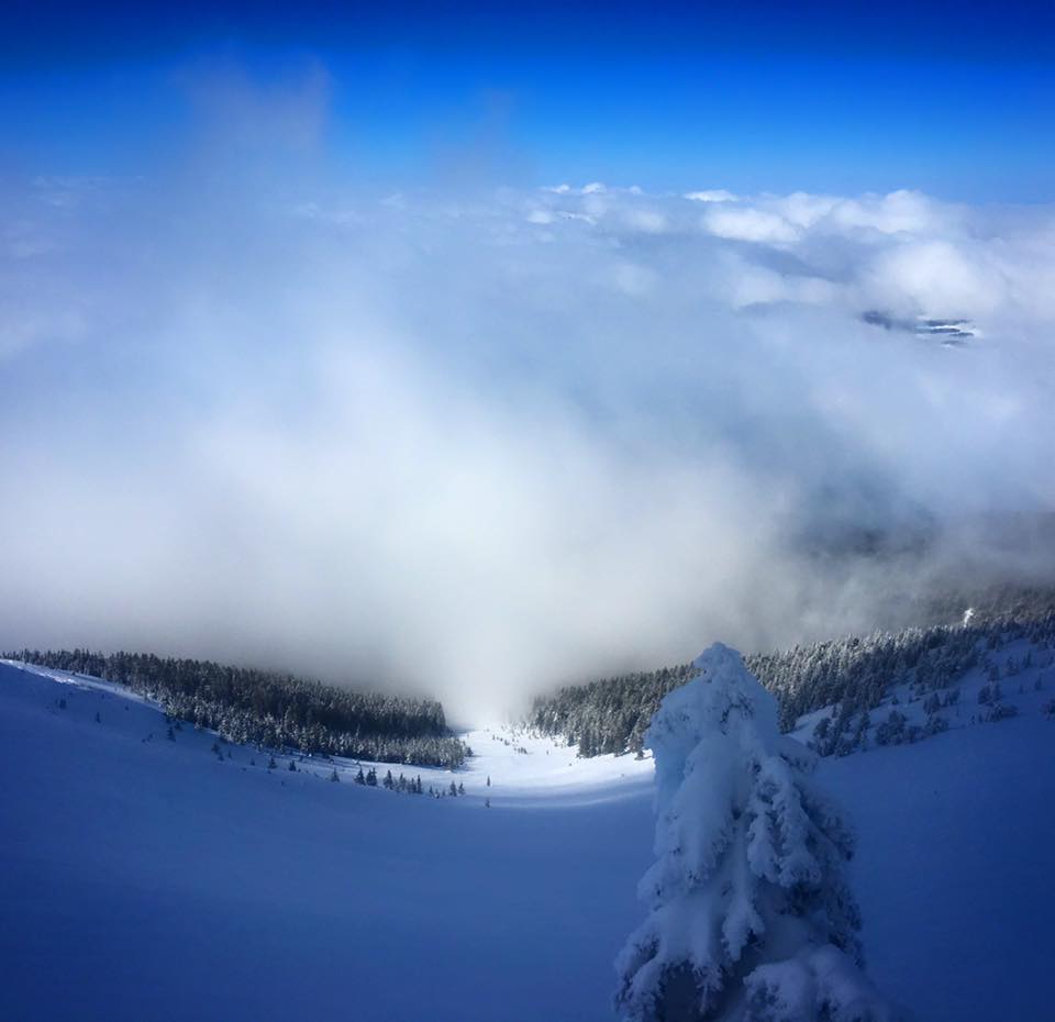
Flagstaff, Arizona - Backcountry of The San Francisco Peaks and Kachina Peaks Wilderness
Backcountry travel in avalanche terrain is NOT recommended for the period starting on Friday morning, extending through the entire weekend and potentially into midweek.
Due to avalanche mitigation work Arizona Snowbowl ski area will close uphill access from Friday evening January 20th to Sunday morning January 22, 2017.
Locations above 7000’ are expected to receive 12 and 24 inches of new snow, with snow water equivalent (SWE) between 2 and 3 inches. Heavy snow loads will accumulate on several observed potential weak layers, including old wind slab, buried surface hoar, near surface facets and depth hoar. The good news is that our base is quickly getting deeper. Human triggered and natural avalanches were reported over the weekend.
The National Weather Service in Flagstaff has issued a WINTER STORM WARNING - IN EFFECT FROM 6 AM THURSDAY JANUARY 19 TO NOON MST SATURDAY JANUARY 21 FOR NORTHERN ARIZONA LOCATIONS ABOVE 5500 FEET.
Avalanche problems will be primarily STORM SNOW, during and soon after precipitation events, however we anticipate lingering WIND SLAB and PERSISTENT SLAB problems, potentially lasting through next week and beyond. Steep slopes on all aspects above and near treeline will be vulnerable to avalanches. Untrained or inexperienced users are particularly vulnerable to the lure of powder without recognition of the potentially deadly consequences.
These events are not surprising as numerous stability tests performed last weekend revealed persistent slab problems, including MLK weekend storm-snow poorly bonding to the rain crusts from the previous week. Careful examination reveals tiny faceted crystals both above and below the crusts at many locations (S, SW, and W) between 10000 and 11500 ft elevations. Both Extended Column (ECT) and Propagation Saw Tests (PST) occasionally indicated significant fracture propagation propensity, however variability was high, with some test not propagating at all.
Last weekend, there were numerous reports of surface hoar development on a range of aspects and elevations.
Backcountry skiers and boarder should be particularly aware of (and avoid) terrain traps, such as the steep sided narrow gullies that characterize sub-treeline conditions of the Peaks. Stay out of these when possible and cross them one at a time with spotter if they cannot be avoided. Low angle (<30°) tree skiing, with no steeper slopes overhead will be your safe bet.
Current Problems (noninclusive) more info


Persistent weak layers include: buried surface hoar, depth hoar, near-surface facets, or faceted snow. Persistent weak layers can continue to produce avalanches for days, weeks or even months, making them especially dangerous and tricky. As additional snow and wind events build a thicker slab on top of the persistent weak layer, this avalanche problem may develop into a Deep Persistent Slab.
Images
Alison Clay Bowl, January 16, 2017. New snow covers debris from a skier triggered avalanche that occurred here just two days before this photo was taken by Josh Langdon.
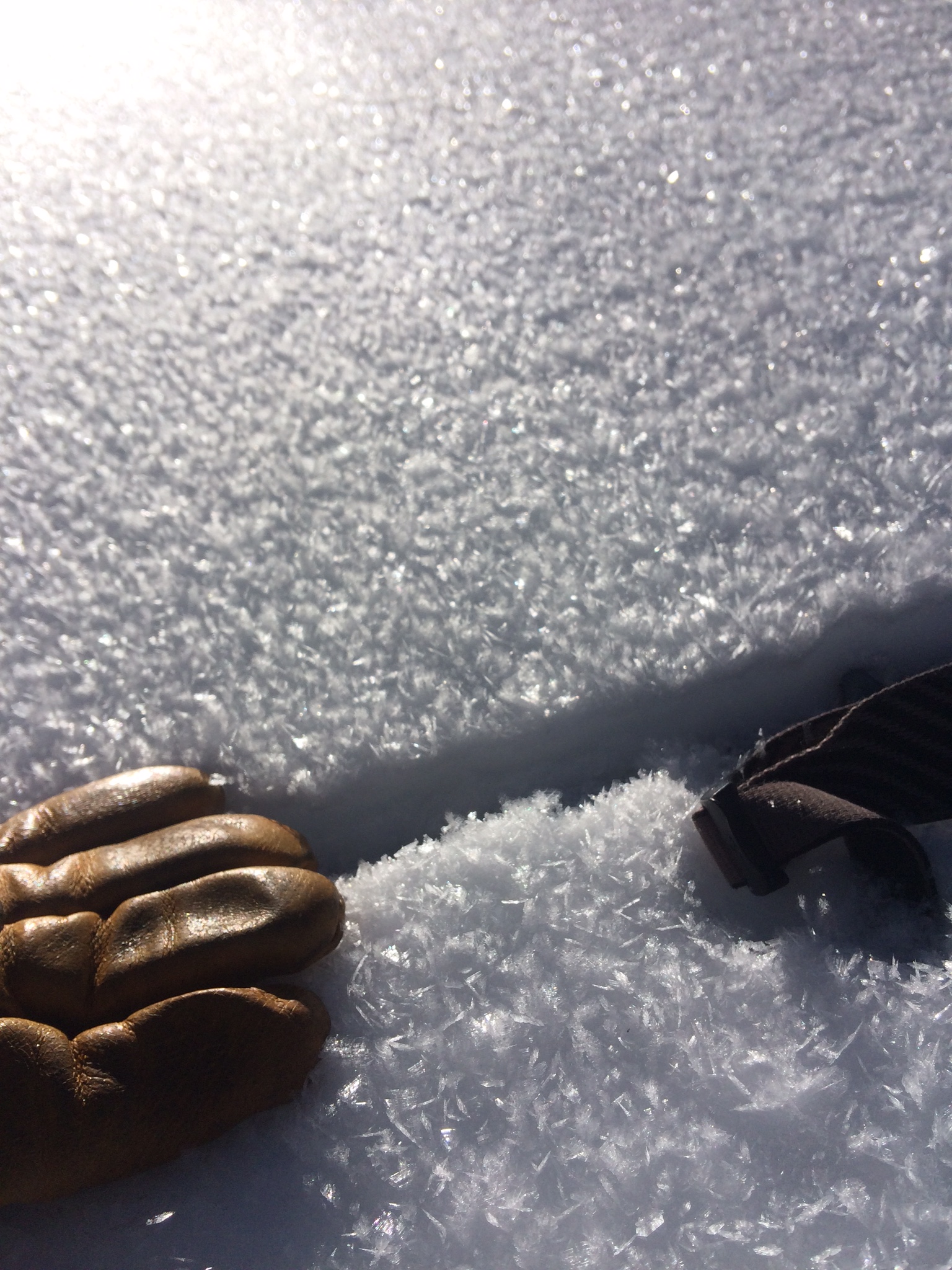
Inner Basin surface hoar, January 18, 2017. Steep slopes with surface hoar buried by new snow is a deadly combination. Photo by Derik Spice.
Final Thoughts
Want to learn more safe backcountry habits? KPAC offers level I and II avalanche courses. They are filling up fast!!!
During winter, backcountry permits are required to access the Kachina Peaks Wilderness. More info
Note: Uphill access has opened at Arizona Snowbowl. It may be restricted or closed due to heavy snow and avalanche danger. Access to the Humphreys Summit trailhead is always available from the lower lots of the ski area, below the gate. Travel safe! arizonasnowbowl.com/safety
Weather
The first pulse was a short wave trough, starting on Thursday and was forecasted to lay down less than a foot at higher elevation. Snow level started at 6000 feet and dropped to 5000 feet by Thursday night. Snowfall will taper off on Friday morning.
A second pulse arrives on Friday evening and lasts through Saturday morning. This slightly longer wave trough will have the greatest precipitation potential. We anticipate heavy snowfall with accumulations in the 1 to 1.5 foot range above 10000 ft.
A fast moving short wave ridge will create another brief break until a third colder pulse arrives on Sunday night. Atmospheric instability is expected to last into midweek with lingering snow showers. Snowline will drop to 4500 feet, with breezy winds out of the southwest lingering. Subfreezing maximum temperatures and moderate winds will prevail for the first half of the workweek above 7000 ft.
Station Information:
On the morning of Friday January 20th the Inner Basin SNOTEL site (Snowslide) reported a snow depth of 68 inches (173 cm) at 9700 ft, and Arizona Snowbowl reported 79 inches (201 cm) at 10800 ft. These values are expected to increase dramatically as heavy precipitation continues periodically for the next several days. Since January 14 the SNOTEL temperatures ranged between 11 and 35°F and Agassiz station between 12 and 25°F.
Authored/Edited By: Derik Spice, David Lovejoy, Troy Marino
Avalanche Problems/Characters
The avalanche problem/character describes part of the current avalanche danger. However because we only realease a summary once a week, the current avalanche problem will likely change.
Understanding avalanche problems is essential, because it allows you to determine your approach and strategies to risk treatment. Below are brief descriptions of avalanche problems/characters, and links to detailed information on the problem, formation, patterns, recognition, and avoidance strategies.
Avalanche Problems Explained
Also see the North American Danger Scale.
Loose Dry

Release of dry unconsolidated snow. These avalanches typically occur within layers of soft snow near the surface of the snowpack. Loose-dry avalanches start at a point and entrain snow as they move downhill, forming a fan-shaped avalanche. Other names for loose-dry avalanches include point-release avalanches or sluffs. Loose-dry avalanches can trigger slab avalanches that break into deeper snow layers.
Loose Dry avalanches are usually relatively harmless to people. They can be hazardous if you are caught and carried into or over a terrain trap (e.g. gully, rocks, dense timber, cliff, crevasse) or down a long slope. Avoid traveling in or above terrain traps when Loose Dry avalanches are likely. more info
Storm Slab
Release of a soft cohesive layer (a slab) of new snow that breaks within the storm snow or on the old snow surface. Storm-slab problems typically last between a few hours and few days. Storm-slabs that form over a persistent weak layer (surface hoar, depth hoar, or near-surface facets) may be termed Persistent Slabs or may develop into Persistent Slabs.
You can reduce your risk from Storm Slabs by waiting a day or two after a storm before venturing into steep terrain. Storm slabs are most dangerous on slopes with terrain traps, such as timber, gullies, over cliffs, or terrain features that make it difficult for a rider to escape off the side. more info
Wind Slab
Release of a cohesive layer of snow (a slab) formed by the wind. Wind typically transports snow from the upwind sides of terrain features and deposits snow on the downwind side. Wind slabs are often smooth and rounded and sometimes sound hollow, and can range from soft to hard. Wind slabs that form over a persistent weak layer (surface hoar, depth hoar, or near-surface facets) may be termed Persistent Slabs or may develop into Persistent Slabs.
Wind Slabs form in specific areas, and are confined to lee and cross-loaded terrain features. They can be avoided by sticking to sheltered or wind-scoured areas. more info
Persistent Slab
Release of a cohesive layer of soft to hard snow (a slab) in the middle to upper snowpack, when the bond to an underlying persistent weak layer breaks. Persistent layers include: surface hoar, depth hoar, near-surface facets, or faceted snow. Persistent weak layers can continue to produce avalanches for days, weeks or even months, making them especially dangerous and tricky. As additional snow and wind events build a thicker slab on top of the persistent weak layer, this avalanche problem may develop into a Deep Persistent Slab.
The best ways to manage the risk from Persistent Slabs is to make conservative terrain choices. They can be triggered by light loads and weeks after the last storm. The slabs often propagate in surprising and unpredictable ways. This makes this problem difficult to predict and manage and requires a wide safety buffer to handle the uncertainty. more info
Deep Persistent Slab

Release of a thick cohesive layer of hard snow (a slab), when the bond breaks between the slab and an underlying persistent weak layer, deep in the snowpack or near the ground. The most common persistent weak layers involved in deep, persistent slabs are depth hoar or facets surrounding a deeply buried crust. Deep Persistent Slabs are typically hard to trigger, are very destructive and dangerous due to the large mass of snow involved, and can persist for months once developed. They are often triggered from areas where the snow is shallow and weak, and are particularly difficult to forecast for and manage. They commonly develop when Persistent Slabs become more deeply buried over time.
Deep Persistent Slabs are destructive and deadly events that can take months to stabilize. You can trigger them from well down in the avalanche path, and after dozens of tracks have crossed the slope. more info
Loose Wet

Release of wet unconsolidated snow or slush. These avalanches typically occur within layers of wet snow near the surface of the snowpack, but they may quickly gouge into lower snowpack layers. Like Loose Dry Avalanches, they start at a point and entrain snow as they move downhill, forming a fan-shaped avalanche. They generally move slowly, but can contain enough mass to cause significant damage to trees, cars or buildings. Other names for loose-wet avalanches include point-release avalanches or sluffs. Loose Wet avalanches can trigger slab avalanches that break into deeper snow layers.
Travel when the snow surface is colder and stronger. Plan your trips to avoid crossing on or under very steep slopes in the afternoon. Move to colder, shadier slopes once the snow surface turns slushly. Avoid steep, sunlit slopes above terrain traps, cliffs areas and long sustained steep pitches. more info
Wet Slab

Release of a cohesive layer of snow (a slab) that is generally moist or wet when the flow of liquid water weakens the bond between the slab and the surface below (snow or ground). They often occur during prolonged warming events and/or rain-on-snow events. Wet Slabs can be very destructive.
Avoid terrain where and when you suspect Wet Slab avalanche activity. Give yourself a wide safety buffer to handle the uncertainty. more info
Cornice Fall

Cornice Fall is the release of an overhanging mass of snow that forms as the wind moves snow over a sharp terrain feature, such as a ridge, and deposits snow on the downwind (leeward) side. Cornices range in size from small wind lips of soft snow to large overhangs of hard snow that are 30 feet (10 meters) or taller. They can break off the terrain suddenly and pull back onto the ridge top and catch people by surprise even on the flat ground above the slope. Even small cornices can have enough mass to be destructive and deadly. Cornice Fall can entrain loose surface snow or trigger slab avalanches.
Cornices can never be trusted and avoiding them is necessary for safe backcountry travel. Stay well back from ridge line areas with cornices. They often overhang the ridge edge can be triggered remotely. Avoid areas underneath cornices. Even small Cornice Fall can trigger a larger avalanche and large Cornice Fall can easily crush a human. Periods of significant temperature warm-up are times to be particularly aware.
Large cornices are generally rare in Arizona, but they have been observed during very snowy winters. more info
Glide

Release of the entire snow cover as a result of gliding over the ground. Glide avalanches can be composed of wet, moist, or almost entirely dry snow. They typically occur in very specific paths, where the slope is steep enough and the ground surface is relatively smooth. The are often proceeded by full depth cracks (glide cracks), though the time between the appearance of a crack and an avalanche can vary between seconds and months. Glide avalanches are unlikely to be triggered by a person, are nearly impossible to forecast, and thus pose a hazard that is extremely difficult to manage.
Predicting the release of Glide Avalanches is very challenging. Because Glide Avalanches only occur on very specific slopes, safe travel relies on identifying and avoiding those slopes. Glide cracks are a significant indicator, as are recent Glide Avalanches.
Glide avalanches are very uncommon in Arizona. more info
