Snowpack Summary for Friday, February 3, 2017 6:34 PM Unseasonably warm temperatures are generally increasing snowpack stability.
This summary expired Feb. 05, 2017 6:34 PM
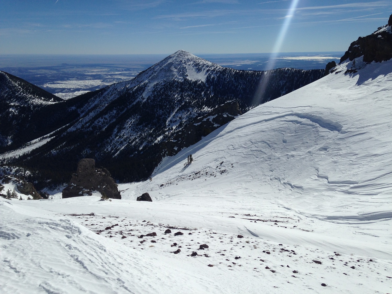
Flagstaff, Arizona - Backcountry of The San Francisco Peaks and Kachina Peaks Wilderness
No new natural or human triggered avalanches have been reported since Humphrey's Cirque and Snowslide Canyon avalanches, discussed in last week's snowpack summary.
The Snowslide Avalanche took out 10" diameter trees. This would have been an unsurvivable avalanche.
Unseasonably warm daytime temperatures have contributed to snowpack bonding, strengthening and densification. Snow from the storm cycle that produced 93" has settled and sublimated reducing its volume and mass by 10% or much more in some places. On some north aspects, much of the new snow was stripped by winds.
Across the San Francisco Peaks, widely variable windslab and stormslab layers sit atop decomposing facets and hard rain event crusts...Southwest facing upper elevation terrain may have a reactive wind slab from last Friday- Sunday's extended northeast wind loading event.
Watch for relatively shallow and recently deposited wind slab on northeast, east, and southeast facing aspects. As in the case with snow falling out of the sky during a storm, wind blown snow also needs time to bond with the snowpack below.
A delayed report was received from riders who triggered a loose snow, point-release avalanche on a steep north facing cinder cone slope, below 8000 ft. This very small avalanche occurred on January 25th.
Stability tests conducted in upper elevation starting zones show strong thick slabs with low to moderate reactivity on aspects besides the loaded southwest above treeline terrain. This wind slab is perched on top of a highly variable lower snowpack structure. Presumably the strong slab (four finger to one finger hardness) from the trifecta storm event occurring January 20th-23rd now have the strength to bridge old weak layers below. Propagation tests have revealed low fracture probation likelihood. The snowpack structure below the trifecta slabs is highly variable, ranging from preserved crusts and facets deep in the snowpack to homogeneous wind slab (top to bottom) and "sastrugi" (patterned snow cover where wind has eroded most of it). In areas where the snowpack is thick, the conundrum is, how strong is the slab? Although the likelihood of a skier or boarder triggering an avalanche seem low, the consequences if it were to slide might be very high, given the high volume and mass potentially entrained.
Coverage is still acceptable down to 7000 ft. but changing rapidly. The soft fun snow below 8000 ft may become melted and gone with the predicted warming trends.
Current Problems (noninclusive) more info


Images
Avalanche and crown flank fracture on easterly slopes of Snowslide Canyon. This occurred during the January 20-23, 2017 storm cycle, and later obscured by winds and snow.
Photo by Carlos Danel
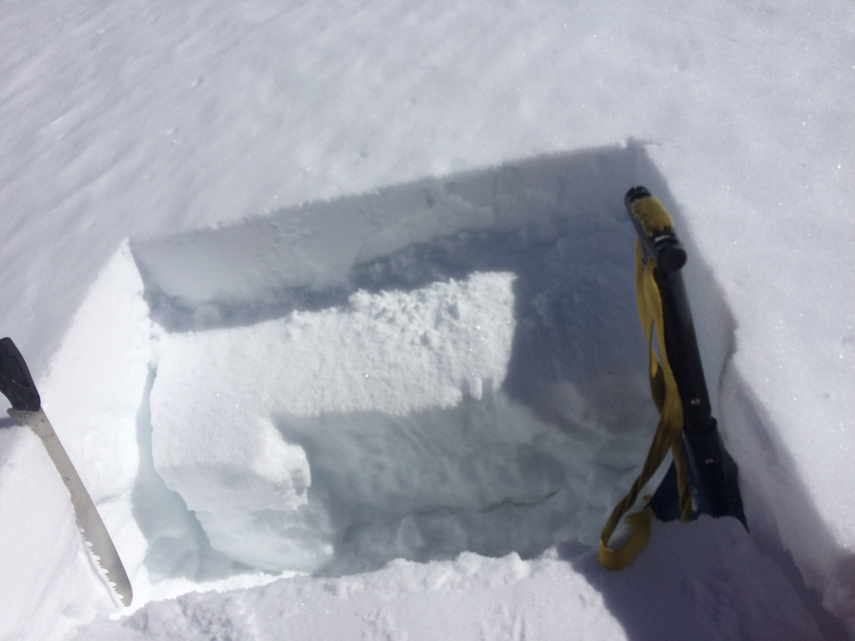
Hard slab failure on southwest slope at 11,400'. ECTP11Q1.
Final Thoughts
Travelers are advised to exercise caution, make slope specific evaluations and most of all, know where you are going and be prepared for the unexpected. As always, please treat this summary with appropriately guarded skepticism, make your own assessments, and contribute to our body of knowledge by reporting your observations.
Arizona Snowbowl uphill policy.
Want to learn more safe backcountry habits? KPAC offers level I and II avalanche courses. They are filling up fast!!!
During winter, backcountry permits are required to access the Kachina Peaks Wilderness. More info
Weather
Weather station information:
On the morning of Friday February 3rd the Inner Basin SNOTEL site (Snowslide) reported a snow depth of 76 inches (193 cm) at 9700’, and Arizona Snowbowl reported 86 inches ( 219 cm) at 10,800’. Since January 27th, SNOTEL temperatures ranged between -1° and 48° F, and Agassiz station between 12 and 42° F.
Authored/Edited By: Derik Spice, David Lovejoy, Troy Marino
Avalanche Problems/Characters
The avalanche problem/character describes part of the current avalanche danger. However because we only realease a summary once a week, the current avalanche problem will likely change.
Understanding avalanche problems is essential, because it allows you to determine your approach and strategies to risk treatment. Below are brief descriptions of avalanche problems/characters, and links to detailed information on the problem, formation, patterns, recognition, and avoidance strategies.
Avalanche Problems Explained
Also see the North American Danger Scale.
Loose Dry

Release of dry unconsolidated snow. These avalanches typically occur within layers of soft snow near the surface of the snowpack. Loose-dry avalanches start at a point and entrain snow as they move downhill, forming a fan-shaped avalanche. Other names for loose-dry avalanches include point-release avalanches or sluffs. Loose-dry avalanches can trigger slab avalanches that break into deeper snow layers.
Loose Dry avalanches are usually relatively harmless to people. They can be hazardous if you are caught and carried into or over a terrain trap (e.g. gully, rocks, dense timber, cliff, crevasse) or down a long slope. Avoid traveling in or above terrain traps when Loose Dry avalanches are likely. more info
Storm Slab

Release of a soft cohesive layer (a slab) of new snow that breaks within the storm snow or on the old snow surface. Storm-slab problems typically last between a few hours and few days. Storm-slabs that form over a persistent weak layer (surface hoar, depth hoar, or near-surface facets) may be termed Persistent Slabs or may develop into Persistent Slabs.
You can reduce your risk from Storm Slabs by waiting a day or two after a storm before venturing into steep terrain. Storm slabs are most dangerous on slopes with terrain traps, such as timber, gullies, over cliffs, or terrain features that make it difficult for a rider to escape off the side. more info
Wind Slab
Release of a cohesive layer of snow (a slab) formed by the wind. Wind typically transports snow from the upwind sides of terrain features and deposits snow on the downwind side. Wind slabs are often smooth and rounded and sometimes sound hollow, and can range from soft to hard. Wind slabs that form over a persistent weak layer (surface hoar, depth hoar, or near-surface facets) may be termed Persistent Slabs or may develop into Persistent Slabs.
Wind Slabs form in specific areas, and are confined to lee and cross-loaded terrain features. They can be avoided by sticking to sheltered or wind-scoured areas. more info
Persistent Slab

Release of a cohesive layer of soft to hard snow (a slab) in the middle to upper snowpack, when the bond to an underlying persistent weak layer breaks. Persistent layers include: surface hoar, depth hoar, near-surface facets, or faceted snow. Persistent weak layers can continue to produce avalanches for days, weeks or even months, making them especially dangerous and tricky. As additional snow and wind events build a thicker slab on top of the persistent weak layer, this avalanche problem may develop into a Deep Persistent Slab.
The best ways to manage the risk from Persistent Slabs is to make conservative terrain choices. They can be triggered by light loads and weeks after the last storm. The slabs often propagate in surprising and unpredictable ways. This makes this problem difficult to predict and manage and requires a wide safety buffer to handle the uncertainty. more info
Deep Persistent Slab

Release of a thick cohesive layer of hard snow (a slab), when the bond breaks between the slab and an underlying persistent weak layer, deep in the snowpack or near the ground. The most common persistent weak layers involved in deep, persistent slabs are depth hoar or facets surrounding a deeply buried crust. Deep Persistent Slabs are typically hard to trigger, are very destructive and dangerous due to the large mass of snow involved, and can persist for months once developed. They are often triggered from areas where the snow is shallow and weak, and are particularly difficult to forecast for and manage. They commonly develop when Persistent Slabs become more deeply buried over time.
Deep Persistent Slabs are destructive and deadly events that can take months to stabilize. You can trigger them from well down in the avalanche path, and after dozens of tracks have crossed the slope. more info
Loose Wet
Release of wet unconsolidated snow or slush. These avalanches typically occur within layers of wet snow near the surface of the snowpack, but they may quickly gouge into lower snowpack layers. Like Loose Dry Avalanches, they start at a point and entrain snow as they move downhill, forming a fan-shaped avalanche. They generally move slowly, but can contain enough mass to cause significant damage to trees, cars or buildings. Other names for loose-wet avalanches include point-release avalanches or sluffs. Loose Wet avalanches can trigger slab avalanches that break into deeper snow layers.
Travel when the snow surface is colder and stronger. Plan your trips to avoid crossing on or under very steep slopes in the afternoon. Move to colder, shadier slopes once the snow surface turns slushly. Avoid steep, sunlit slopes above terrain traps, cliffs areas and long sustained steep pitches. more info
Wet Slab

Release of a cohesive layer of snow (a slab) that is generally moist or wet when the flow of liquid water weakens the bond between the slab and the surface below (snow or ground). They often occur during prolonged warming events and/or rain-on-snow events. Wet Slabs can be very destructive.
Avoid terrain where and when you suspect Wet Slab avalanche activity. Give yourself a wide safety buffer to handle the uncertainty. more info
Cornice Fall

Cornice Fall is the release of an overhanging mass of snow that forms as the wind moves snow over a sharp terrain feature, such as a ridge, and deposits snow on the downwind (leeward) side. Cornices range in size from small wind lips of soft snow to large overhangs of hard snow that are 30 feet (10 meters) or taller. They can break off the terrain suddenly and pull back onto the ridge top and catch people by surprise even on the flat ground above the slope. Even small cornices can have enough mass to be destructive and deadly. Cornice Fall can entrain loose surface snow or trigger slab avalanches.
Cornices can never be trusted and avoiding them is necessary for safe backcountry travel. Stay well back from ridge line areas with cornices. They often overhang the ridge edge can be triggered remotely. Avoid areas underneath cornices. Even small Cornice Fall can trigger a larger avalanche and large Cornice Fall can easily crush a human. Periods of significant temperature warm-up are times to be particularly aware.
Large cornices are generally rare in Arizona, but they have been observed during very snowy winters. more info
Glide

Release of the entire snow cover as a result of gliding over the ground. Glide avalanches can be composed of wet, moist, or almost entirely dry snow. They typically occur in very specific paths, where the slope is steep enough and the ground surface is relatively smooth. The are often proceeded by full depth cracks (glide cracks), though the time between the appearance of a crack and an avalanche can vary between seconds and months. Glide avalanches are unlikely to be triggered by a person, are nearly impossible to forecast, and thus pose a hazard that is extremely difficult to manage.
Predicting the release of Glide Avalanches is very challenging. Because Glide Avalanches only occur on very specific slopes, safe travel relies on identifying and avoiding those slopes. Glide cracks are a significant indicator, as are recent Glide Avalanches.
Glide avalanches are very uncommon in Arizona. more info
