Snowpack Summary for Thursday, February 21, 2019 8:40 AM February Storm Cycle and Avalanche Hazard Continues
This summary expired Feb. 23, 2019 8:40 AM
Flagstaff, Arizona - Backcountry of The San Francisco Peaks and Kachina Peaks Wilderness
Yesterday we observed evidence of a storm/wind slab release near Rustler Peak. Read more below.
Overall the snowpack structure has become quite complex, with huge variability and uncertainty. Many observations reveal a snowpack with poor structure, good strength and little to no reactivity. Others show potential failure energy hidden in persistent weak layers. And some observations even show good structure. Recent column tests on southwest slopes above 11,000' reveal continued persistent slab problems.
With the current forecast of 2-3 feet near treeline, avalanches may become very likely on Thurs/Fri, Feb. 21/22 . Cold temperatures and wind may keep the avalanche hazard elevated through the weekend.
Avoiding avalanche terrain during and 24 hours after powerful storms will significantly decrease your likelihood of triggering an avalanche. Also avoid convex pillows of wind-drifted snow on lee and cross-loaded terrain features.
Read more about recent avalanches.
Large avalanche in Snowslide Canyon on Feb. 5 or 6. Characteristic classification is HS-N-R4D4-O
There was a crown line about 1/2 way down Jay's Slide - a NNW aspect on Fremont. Picture from Sat. Feb 9, 2019. This avalanche likely occurred on Tuesday or Wednesday, February 5 or 6. Estimated classification is U-N-R2D2-U.
The warm and windy St. Valentine storm has created a hard and icy layers. Avalanches will likely initiate in newer snow above these layers, but could potentially step down into deeper persistent slab problems, creating larger and more destructive avalanches. The hard Valentine layers may act as a sliding surface for failures above. Icy Valentine layers may send you on an uncontrolled slide, crampons and ice axe may be helpful.
Unfortunately, we have not had a chance to observe/test northerly and easterly slopes. It would be best to minimize that uncertainty before committing to steep northerly and easterly slopes, and take note of the recent Rustler Peak avalanches (see below).
North, northwest and west-northwest winds blew Tuesday night through Wednesday morning - watch for wind slabs on south, southeast and east aspects. Winds shifted to the south this afternoon. Southwest winds are forecasted over the next 48 hours. Watch for slab development on east, northeast and northerly slopes.
Cornices are forming on the lee side of ridgelines. Avoid cornices, as they may collapse unpredictably and send you downslope.
Coverage has drastically improved! You will find great skiing and riding on low avalanche hazard slopes if you stay off of and out from under slopes that are greater than 30° in steepness. Low elevation (<9000') slopes are filling in.
Current Problems (noninclusive) more info

Rocks are getting covered above treeline and new storm snow may struggle to bond with the cold President's Day snow. Storm slabs commonly form during periods of light or no wind. The President's Weekend Storm had little wind.
New snow may also fail as unconsolidated point (loose dry) releases. Storm slabs and loose dry releases are generally small and harmless but may become dangerous on slopes with terrain traps, such as timber, gullies, over cliffs, or terrain features that make it difficult for a rider to escape off the side.

South and southwest winds are forecasted over the next 24 hours then switching to the west-northwest.
Post storm winds may create slabs on other aspects. As always watch for cross loading in gullies. Slopes just below ridges and on the flanks of shoulders should be considered suspect.
Cornices are starting to form on the lee side of ridgelines. Avoid cornices, as they may collapse unpredictably and send you downslope.
Give new snow time to bond with the old snow. Waiting at least 24 hours after new snow, and 48 hours after wind events will dramatically decrease your chances of finding unstable storm/wind slabs.

Watch for near surface facets above and below the hard Valentine's day layers. Also, basel facets may still be reactive, especially where the snowpack was less than 1.5m deep prior to the President's day storm.
New significant storm and wind slabs may cause persistent weak layers to fail. Worse, new slabs may push deep hidden weak layers just to the brink of failure, waiting to be triggered by an unsuspecting backcountry traveler.
This problem led to the large Snowslide Canyon avalanche that naturally released on an easterly aspect near 12,000', the first week of February.
The December facet layer is getting buried quite deep now and will be very difficult to predict and manage.
Images
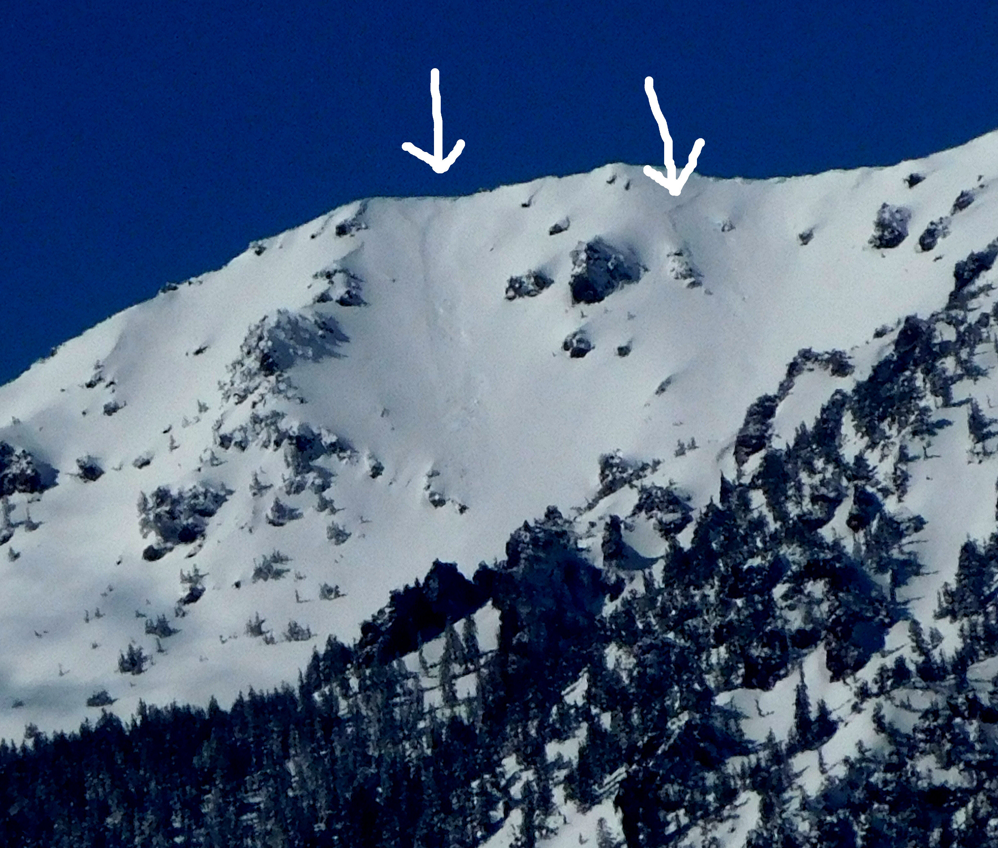
Storm and/or wind slab avalanches released on Rustler peak. Photo from Feb. 20th. Though not big, these look large enough to injure and bury a person. (35.338, -111.683, ~ENE aspect)
Final Thoughts
Backcountry permits are required for travel in the Kachina Peaks Wilderness and available at local USFS locations, as well as, at the Agassiz Lodge on Saturday and Sunday 8:30 -11:30.
For information on uphill travel within the Arizona Snowbowl ski area, please refer to www.flagstaffuphill.com and https://www.snowbowl.ski/the-mountain/uphill-access/ for details. Access to the Kachina Peaks Wilderness is available from the lower lots at Snowbowl via the Humphreys Trail and Kachina Trail.
Weather
The President's Day storm delivered ~21" of light champaign powder at 10,800'. Winds were calm and light. North, northwest and west-northwest winds blew Tuesday night through Wednesday morning, Feb. 20th. Winds shifted to the south this afternoon, Wednesday.
A major winter storm will bring widespread and significant snow Thursday into Friday (Feb. 21/22). Treeline totals may push 3+ feet of accumulation. Quieter weather returns for the weekend with continued below normal temperatures.
On Tuesday, Feb. 19th, the Inner Basin SNOTEL site (Snowslide) reported a snow depth of 58” (147 cm) at 9,730'. Arizona Snowbowl reported a settled base of 84” (213 cm) at 10,800'. So far this winter, 212" (538 cm) of snow have fallen at the mid-mountain study site. Since February 15th, SNOTEL temperatures have ranged between -8° F on February 19th, and 33° F on Feb. 15th. For the same period, ASBTP (11,555') reported temperatures between -3° F on Feb. 1tth, and 23° F on Feb. 15th.
Authored/Edited By: Troy Marino
Avalanche Problems/Characters
The avalanche problem/character describes part of the current avalanche danger. However because we only realease a summary once a week, the current avalanche problem will likely change.
Understanding avalanche problems is essential, because it allows you to determine your approach and strategies to risk treatment. Below are brief descriptions of avalanche problems/characters, and links to detailed information on the problem, formation, patterns, recognition, and avoidance strategies.
Avalanche Problems Explained
Also see the North American Danger Scale.
Loose Dry

Release of dry unconsolidated snow. These avalanches typically occur within layers of soft snow near the surface of the snowpack. Loose-dry avalanches start at a point and entrain snow as they move downhill, forming a fan-shaped avalanche. Other names for loose-dry avalanches include point-release avalanches or sluffs. Loose-dry avalanches can trigger slab avalanches that break into deeper snow layers.
Loose Dry avalanches are usually relatively harmless to people. They can be hazardous if you are caught and carried into or over a terrain trap (e.g. gully, rocks, dense timber, cliff, crevasse) or down a long slope. Avoid traveling in or above terrain traps when Loose Dry avalanches are likely. more info
Storm Slab
Release of a soft cohesive layer (a slab) of new snow that breaks within the storm snow or on the old snow surface. Storm-slab problems typically last between a few hours and few days. Storm-slabs that form over a persistent weak layer (surface hoar, depth hoar, or near-surface facets) may be termed Persistent Slabs or may develop into Persistent Slabs.
You can reduce your risk from Storm Slabs by waiting a day or two after a storm before venturing into steep terrain. Storm slabs are most dangerous on slopes with terrain traps, such as timber, gullies, over cliffs, or terrain features that make it difficult for a rider to escape off the side. more info
Wind Slab
Release of a cohesive layer of snow (a slab) formed by the wind. Wind typically transports snow from the upwind sides of terrain features and deposits snow on the downwind side. Wind slabs are often smooth and rounded and sometimes sound hollow, and can range from soft to hard. Wind slabs that form over a persistent weak layer (surface hoar, depth hoar, or near-surface facets) may be termed Persistent Slabs or may develop into Persistent Slabs.
Wind Slabs form in specific areas, and are confined to lee and cross-loaded terrain features. They can be avoided by sticking to sheltered or wind-scoured areas. more info
Persistent Slab
Release of a cohesive layer of soft to hard snow (a slab) in the middle to upper snowpack, when the bond to an underlying persistent weak layer breaks. Persistent layers include: surface hoar, depth hoar, near-surface facets, or faceted snow. Persistent weak layers can continue to produce avalanches for days, weeks or even months, making them especially dangerous and tricky. As additional snow and wind events build a thicker slab on top of the persistent weak layer, this avalanche problem may develop into a Deep Persistent Slab.
The best ways to manage the risk from Persistent Slabs is to make conservative terrain choices. They can be triggered by light loads and weeks after the last storm. The slabs often propagate in surprising and unpredictable ways. This makes this problem difficult to predict and manage and requires a wide safety buffer to handle the uncertainty. more info
Deep Persistent Slab

Release of a thick cohesive layer of hard snow (a slab), when the bond breaks between the slab and an underlying persistent weak layer, deep in the snowpack or near the ground. The most common persistent weak layers involved in deep, persistent slabs are depth hoar or facets surrounding a deeply buried crust. Deep Persistent Slabs are typically hard to trigger, are very destructive and dangerous due to the large mass of snow involved, and can persist for months once developed. They are often triggered from areas where the snow is shallow and weak, and are particularly difficult to forecast for and manage. They commonly develop when Persistent Slabs become more deeply buried over time.
Deep Persistent Slabs are destructive and deadly events that can take months to stabilize. You can trigger them from well down in the avalanche path, and after dozens of tracks have crossed the slope. more info
Loose Wet

Release of wet unconsolidated snow or slush. These avalanches typically occur within layers of wet snow near the surface of the snowpack, but they may quickly gouge into lower snowpack layers. Like Loose Dry Avalanches, they start at a point and entrain snow as they move downhill, forming a fan-shaped avalanche. They generally move slowly, but can contain enough mass to cause significant damage to trees, cars or buildings. Other names for loose-wet avalanches include point-release avalanches or sluffs. Loose Wet avalanches can trigger slab avalanches that break into deeper snow layers.
Travel when the snow surface is colder and stronger. Plan your trips to avoid crossing on or under very steep slopes in the afternoon. Move to colder, shadier slopes once the snow surface turns slushly. Avoid steep, sunlit slopes above terrain traps, cliffs areas and long sustained steep pitches. more info
Wet Slab

Release of a cohesive layer of snow (a slab) that is generally moist or wet when the flow of liquid water weakens the bond between the slab and the surface below (snow or ground). They often occur during prolonged warming events and/or rain-on-snow events. Wet Slabs can be very destructive.
Avoid terrain where and when you suspect Wet Slab avalanche activity. Give yourself a wide safety buffer to handle the uncertainty. more info
Cornice Fall

Cornice Fall is the release of an overhanging mass of snow that forms as the wind moves snow over a sharp terrain feature, such as a ridge, and deposits snow on the downwind (leeward) side. Cornices range in size from small wind lips of soft snow to large overhangs of hard snow that are 30 feet (10 meters) or taller. They can break off the terrain suddenly and pull back onto the ridge top and catch people by surprise even on the flat ground above the slope. Even small cornices can have enough mass to be destructive and deadly. Cornice Fall can entrain loose surface snow or trigger slab avalanches.
Cornices can never be trusted and avoiding them is necessary for safe backcountry travel. Stay well back from ridge line areas with cornices. They often overhang the ridge edge can be triggered remotely. Avoid areas underneath cornices. Even small Cornice Fall can trigger a larger avalanche and large Cornice Fall can easily crush a human. Periods of significant temperature warm-up are times to be particularly aware.
Large cornices are generally rare in Arizona, but they have been observed during very snowy winters. more info
Glide

Release of the entire snow cover as a result of gliding over the ground. Glide avalanches can be composed of wet, moist, or almost entirely dry snow. They typically occur in very specific paths, where the slope is steep enough and the ground surface is relatively smooth. The are often proceeded by full depth cracks (glide cracks), though the time between the appearance of a crack and an avalanche can vary between seconds and months. Glide avalanches are unlikely to be triggered by a person, are nearly impossible to forecast, and thus pose a hazard that is extremely difficult to manage.
Predicting the release of Glide Avalanches is very challenging. Because Glide Avalanches only occur on very specific slopes, safe travel relies on identifying and avoiding those slopes. Glide cracks are a significant indicator, as are recent Glide Avalanches.
Glide avalanches are very uncommon in Arizona. more info
