Snowpack Summary for Friday, March 1, 2019 8:13 PM February (Febru-buried!) comes to an end. More precipitation forecasted.
This summary expired Mar. 03, 2019 8:13 PM
Flagstaff, Arizona - Backcountry of The San Francisco Peaks and Kachina Peaks Wilderness
Avoid convex pillows of wind-drifted snow, watch for new wind slab development and avoid overhanging cornices that have formed on leeward sides of ridgelines. Cornices on February 25th. Another system may enter the area approximately Wednesday, March 6th and may keep avalanche hazard elevated.
Rapid warming after storms, or rain on snow may lead to wet avalanche activity. Evidence of a smallish wet avalanches were observed on sunny slopes near and below treeline the past few days. We've seen evidence of wet unstable snow on all steep slopes below 9,500'.
Between February 13th and 26th the snowpack roughly doubled. On those dates respectively, we measured ~150cm and ~300cm of snow on an ESE slope at 12,000' near Rustler Peak. Read more about our February recap.
Snowslide SNOTEL (9,730') reported 20" of new snow and ~3" of snow water equivalent (SWE) between Feb. 2nd and 6th. This resulted in a large avalanche in Snowslide Canyon on Feb. 5th or 6th. Classification is HS-N-R4D4-O. On Feb. 9th a crown line was observed about 1/2 way down Jay's Slide - a NNW aspect on Fremont. This avalanche likely occurred on Tuesday or Wednesday, February 5 or 6. Estimated classification is U-N-R2D2-U.
St. Valentine's Storm:
Heavy dense snow with rain levels near treeline. Snowslide SNOTEL reported 5" of new snow and ~2.5" of SWE between Feb. 14th and 15th. No avalanches observed. New hard/icy crusts in the snowpack.
Presidents Day Weekend Storm:
Snowslide SNOTEL reported 9" of new snow and ~<0.5" of SWE between Feb. 17th and 19th.
This resulted in small storm and/or wind slab avalanches on Rustler peak. Evidence observed on Feb. 20th. Though not big, these may have been large enough to injure and bury a person. Estimated classification for each is is U-N-R2D1.5-U (35.338, -111.683, ~E aspect). The hard Valentine frozen rain layer was a likely bed surface.
Feb. 21/22 Storm:
Snowslide SNOTEL reported 20" of new snow and ~1.4" of SWE between Feb. 20th and 22nd. This resulted in loose snow avalanches triggered by skiers, boarders, and natural small cornice drops. No significant slab avalanches observed.
March 11 update:
An old crown line and avalanche debris were discovered in the Telescope Chute of Doyle Peak. The crown was located at ~10,900' at a choke where the path briefly narrows and steepens. Avalanche debris and small broken trees were found at ~10,400’. This avalanche likely happened during the Feb. 21/22 storm.
Sunshine after storms may destabilize southerly and sunny slopes.
Tree wells are getting deep and tree well immersion suffocation is a real possibility. Coverage is good on most slopes above 9,500', with plenty of safer low angle (<30°) touring.
Current Problems (noninclusive) more info

Wind slabs are often smooth and rounded and sometimes sound hollow, and can range from soft to hard. Avoid slabs and convex pillows of wind-drifted snow on lee and cross-loaded terrain features.
Forecast calls for new snow and southwest and west winds this weekend, so watch for northeast and easterly wind slab formation. Also, chutes and gullies on other aspects may cross load.
Waiting at least 48 hours after wind events will decrease your chances of finding unstable storm/wind slabs.


During warm weather, surface snow will become saturated with water. Deteriorating riding conditions (sticky slush) and rollerballs are an indication that you should move to a colder slope.
Read more about spring travel strategies.
Images
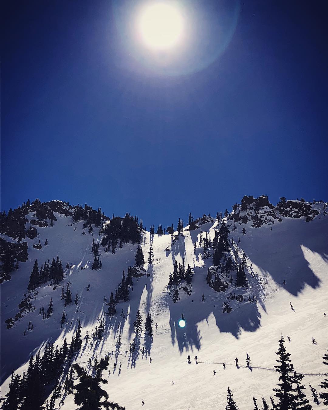
Even when things appear stable, there's always some uncertainty. Therefore don't expose all or most of the group to avalanche terrain. This group should spread out more.
Feb. 26 J. Langdon photo.
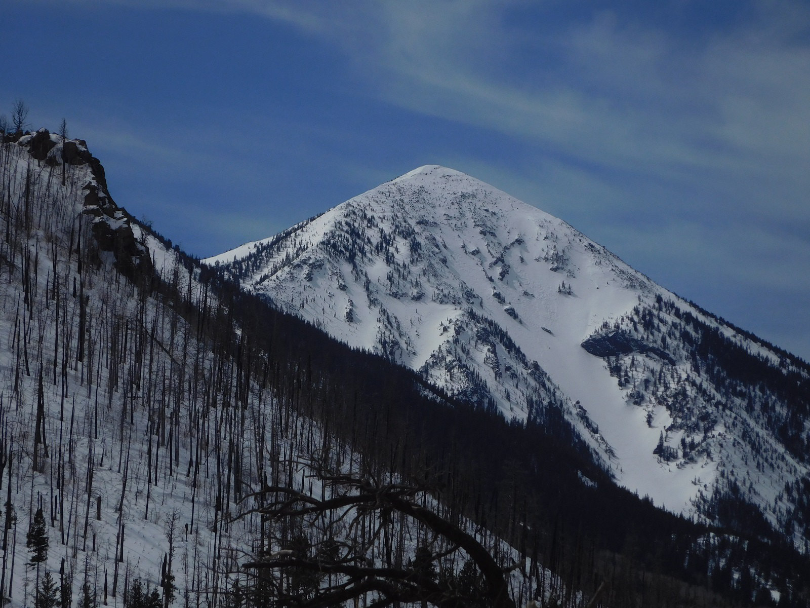
This north-northeast face of Fremont Peak had ski tracks on Wednesday, Feb. 27th. Two days later the tracks were covered by new snow blown in from southwest winds.
Friday, March 1st, 2019 photo.
Final Thoughts
Backcountry permits are required for travel in the Kachina Peaks Wilderness and available at local USFS locations, as well as, at the Agassiz Lodge on Saturday and Sunday 8:30 -11:30.
For information on uphill travel within the Arizona Snowbowl ski area, please refer to www.flagstaffuphill.com and https://www.snowbowl.ski/the-mountain/uphill-access/ for details. Access to the Kachina Peaks Wilderness is available from the lower lots at Snowbowl via the Humphreys Trail and Kachina Trail.
Weather
During the past week we have seen a gradual warming trend, high clouds, but no precipitation. By the time of this report, Temperatures have returned to near normal with daytime highs in the 30s at treeline. In the aftermath of last week’s mega storm, winds out of the north and northwest were observed Saturday February 23rd and to a lesser degree on Sunday and into the workweek. On Saturday Feb. 23rd, wind speeds ranged from 15-30 mph with gust in the 40 mph range out of the north and northwest. Breezy conditions returned on Thursday Feb. 28th and Friday Mar. 1st. These were in the 20+ mph range with stronger gusts out of the west and southwest.
During the upcoming weekend, another low pressure system will pass through. Current forecast is for 10 to 18" of snow near treeline, and a snow/rain line near 8000'. This storm will be accompanied by breezy conditions out of the southwest. During the following workweek, the weather will return to near normal temperatures and breezy days. Another storm my enter the area around mid-week, but it's too early to accurately predict anything about timing, intensity or storm track.
On Friday, March 1st, the Inner Basin SNOTEL site (Snowslide) reported a snow depth of 63” (160cm) at 9,730'. Arizona Snowbowl reported a settled base of 98” (249 cm) at 10,800'. So far this winter, 278" (706 cm) of snow has fallen at the mid-mountain study site. Since February 23rd, SNOTEL temperatures have ranged between 8° F on February 24th, and 46° F on March 1st. For the same period, ASBTP (11,555') reported temperatures between 1.6° F on Feb. 23rd, and 35.7° F on March 1st.
Authored/Edited By: Troy Marino, David Lovejoy, Derik Spice
Avalanche Problems/Characters
The avalanche problem/character describes part of the current avalanche danger. However because we only realease a summary once a week, the current avalanche problem will likely change.
Understanding avalanche problems is essential, because it allows you to determine your approach and strategies to risk treatment. Below are brief descriptions of avalanche problems/characters, and links to detailed information on the problem, formation, patterns, recognition, and avoidance strategies.
Avalanche Problems Explained
Also see the North American Danger Scale.
Loose Dry

Release of dry unconsolidated snow. These avalanches typically occur within layers of soft snow near the surface of the snowpack. Loose-dry avalanches start at a point and entrain snow as they move downhill, forming a fan-shaped avalanche. Other names for loose-dry avalanches include point-release avalanches or sluffs. Loose-dry avalanches can trigger slab avalanches that break into deeper snow layers.
Loose Dry avalanches are usually relatively harmless to people. They can be hazardous if you are caught and carried into or over a terrain trap (e.g. gully, rocks, dense timber, cliff, crevasse) or down a long slope. Avoid traveling in or above terrain traps when Loose Dry avalanches are likely. more info
Storm Slab

Release of a soft cohesive layer (a slab) of new snow that breaks within the storm snow or on the old snow surface. Storm-slab problems typically last between a few hours and few days. Storm-slabs that form over a persistent weak layer (surface hoar, depth hoar, or near-surface facets) may be termed Persistent Slabs or may develop into Persistent Slabs.
You can reduce your risk from Storm Slabs by waiting a day or two after a storm before venturing into steep terrain. Storm slabs are most dangerous on slopes with terrain traps, such as timber, gullies, over cliffs, or terrain features that make it difficult for a rider to escape off the side. more info
Wind Slab
Release of a cohesive layer of snow (a slab) formed by the wind. Wind typically transports snow from the upwind sides of terrain features and deposits snow on the downwind side. Wind slabs are often smooth and rounded and sometimes sound hollow, and can range from soft to hard. Wind slabs that form over a persistent weak layer (surface hoar, depth hoar, or near-surface facets) may be termed Persistent Slabs or may develop into Persistent Slabs.
Wind Slabs form in specific areas, and are confined to lee and cross-loaded terrain features. They can be avoided by sticking to sheltered or wind-scoured areas. more info
Persistent Slab

Release of a cohesive layer of soft to hard snow (a slab) in the middle to upper snowpack, when the bond to an underlying persistent weak layer breaks. Persistent layers include: surface hoar, depth hoar, near-surface facets, or faceted snow. Persistent weak layers can continue to produce avalanches for days, weeks or even months, making them especially dangerous and tricky. As additional snow and wind events build a thicker slab on top of the persistent weak layer, this avalanche problem may develop into a Deep Persistent Slab.
The best ways to manage the risk from Persistent Slabs is to make conservative terrain choices. They can be triggered by light loads and weeks after the last storm. The slabs often propagate in surprising and unpredictable ways. This makes this problem difficult to predict and manage and requires a wide safety buffer to handle the uncertainty. more info
Deep Persistent Slab

Release of a thick cohesive layer of hard snow (a slab), when the bond breaks between the slab and an underlying persistent weak layer, deep in the snowpack or near the ground. The most common persistent weak layers involved in deep, persistent slabs are depth hoar or facets surrounding a deeply buried crust. Deep Persistent Slabs are typically hard to trigger, are very destructive and dangerous due to the large mass of snow involved, and can persist for months once developed. They are often triggered from areas where the snow is shallow and weak, and are particularly difficult to forecast for and manage. They commonly develop when Persistent Slabs become more deeply buried over time.
Deep Persistent Slabs are destructive and deadly events that can take months to stabilize. You can trigger them from well down in the avalanche path, and after dozens of tracks have crossed the slope. more info
Loose Wet

Release of wet unconsolidated snow or slush. These avalanches typically occur within layers of wet snow near the surface of the snowpack, but they may quickly gouge into lower snowpack layers. Like Loose Dry Avalanches, they start at a point and entrain snow as they move downhill, forming a fan-shaped avalanche. They generally move slowly, but can contain enough mass to cause significant damage to trees, cars or buildings. Other names for loose-wet avalanches include point-release avalanches or sluffs. Loose Wet avalanches can trigger slab avalanches that break into deeper snow layers.
Travel when the snow surface is colder and stronger. Plan your trips to avoid crossing on or under very steep slopes in the afternoon. Move to colder, shadier slopes once the snow surface turns slushly. Avoid steep, sunlit slopes above terrain traps, cliffs areas and long sustained steep pitches. more info
Wet Slab
Release of a cohesive layer of snow (a slab) that is generally moist or wet when the flow of liquid water weakens the bond between the slab and the surface below (snow or ground). They often occur during prolonged warming events and/or rain-on-snow events. Wet Slabs can be very destructive.
Avoid terrain where and when you suspect Wet Slab avalanche activity. Give yourself a wide safety buffer to handle the uncertainty. more info
Cornice Fall
Cornice Fall is the release of an overhanging mass of snow that forms as the wind moves snow over a sharp terrain feature, such as a ridge, and deposits snow on the downwind (leeward) side. Cornices range in size from small wind lips of soft snow to large overhangs of hard snow that are 30 feet (10 meters) or taller. They can break off the terrain suddenly and pull back onto the ridge top and catch people by surprise even on the flat ground above the slope. Even small cornices can have enough mass to be destructive and deadly. Cornice Fall can entrain loose surface snow or trigger slab avalanches.
Cornices can never be trusted and avoiding them is necessary for safe backcountry travel. Stay well back from ridge line areas with cornices. They often overhang the ridge edge can be triggered remotely. Avoid areas underneath cornices. Even small Cornice Fall can trigger a larger avalanche and large Cornice Fall can easily crush a human. Periods of significant temperature warm-up are times to be particularly aware.
Large cornices are generally rare in Arizona, but they have been observed during very snowy winters. more info
Glide

Release of the entire snow cover as a result of gliding over the ground. Glide avalanches can be composed of wet, moist, or almost entirely dry snow. They typically occur in very specific paths, where the slope is steep enough and the ground surface is relatively smooth. The are often proceeded by full depth cracks (glide cracks), though the time between the appearance of a crack and an avalanche can vary between seconds and months. Glide avalanches are unlikely to be triggered by a person, are nearly impossible to forecast, and thus pose a hazard that is extremely difficult to manage.
Predicting the release of Glide Avalanches is very challenging. Because Glide Avalanches only occur on very specific slopes, safe travel relies on identifying and avoiding those slopes. Glide cracks are a significant indicator, as are recent Glide Avalanches.
Glide avalanches are very uncommon in Arizona. more info
