Snowpack Summary for Friday, April 10, 2020 3:20 PM Backcountry skiing and high risk activities discouraged due to COVID-19
This summary expired Apr. 12, 2020 3:20 PM
Flagstaff, Arizona - Backcountry of The San Francisco Peaks and Kachina Peaks Wilderness
More unsettled weather is in the forecast. As the weather changes, expect corresponding changes in the avalanche hazard. Access to the backcountry currently requires a longer than usual approach, thus this summary is based on limited observations.
Currently Snowbowl Road remains closed. Long approaches/egresses to snowy backcountry slopes will be challenging, requiring extra planning, preparedness and effort. Arizona Snowbowl has suspended all operations, including avalanche hazard mitigation and rescue. Inbound terrain at Arizona Snowbowl is currently closed to all travel.
There is still evidence of failure propagation propensity in our late season snowpack. The suspect layers are facets and crusts about ~40 to 100 cm below the snow surface. There is a low probability (but possibility) that a backcountry traveler will initiate a failure in these buried layers. Though hard to predict, there is a possibility that a traveler may trigger a smaller wind slab or wet avalanche that then overloads these persistent layers, creating a larger more destructive avalanche with greater consequences.
Snowpit data
Spring travel strategies
Recent Avalanche Activity:
- There was a relatively small soft slab natural-avalanche in Snowslide Canyon Bowl, likely on March 18 or 19th. See past summary.
- On Saturday morning, March 14, while using explosives in a closed area, AZ Snowbowl Ski Patrol triggered an avalanche on a northwest slope near 11,900 feet. The crown was 2-4' deep. It ran approximately 800' and was about 75' wide. The debris pile was ~4' deep where it stopped above the Spur catwalk. The failure occurred within frozen needles resting on the March 11 rain crust. Various rain crusts have shown varying reactivity throughout the snow pack.
- No human triggered slab avalanches reported in the backcountry this season.
Travel may be incredibly firm and require ice axe and crampons. Expect dramatically changing conditions throughout the day. If you are making the long trek into the backcountry, come prepared. Conditions are likely to be extremely variable depending on wind exposure/loading and sun exposure.
Current Problems (noninclusive) more info

If a backcountry traveler does trigger a wind slab avalanche, it will likely be relatively small. However the force of that avalanche could overwhelm and step down into a deeper persistent weak layer, creating a larger and more destructive avalanche.

Wet avalanche problems can generally be avoided by skiing earlier in the day and staying off of steeper slopes as temperatures warm up and slush becomes more than a few inches deep.
Images
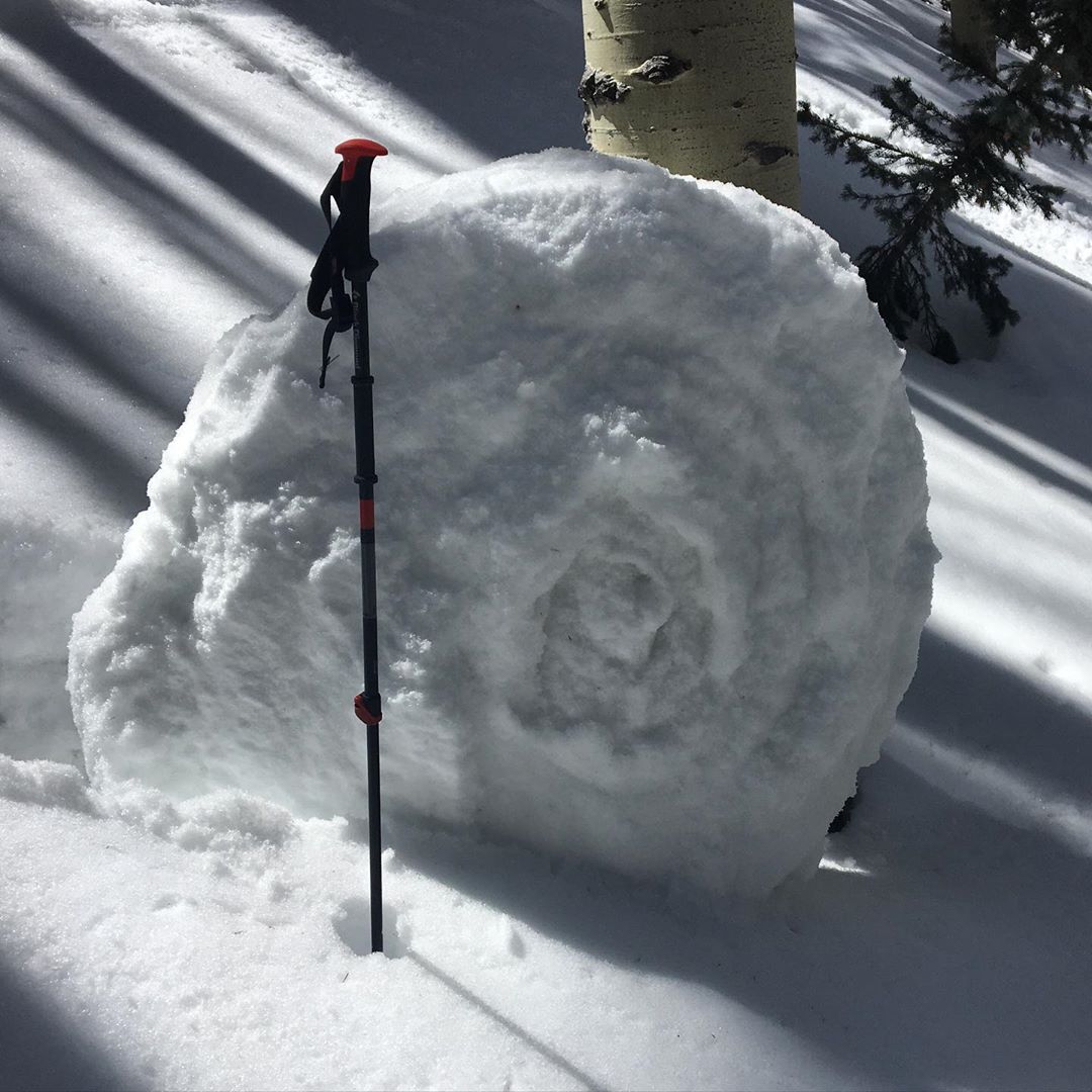
Snow mollusks (a.k.a. roller balls) indicate that steep sunny slopes are getting wet and becoming unstable. April 3 photo by Blair Foust.
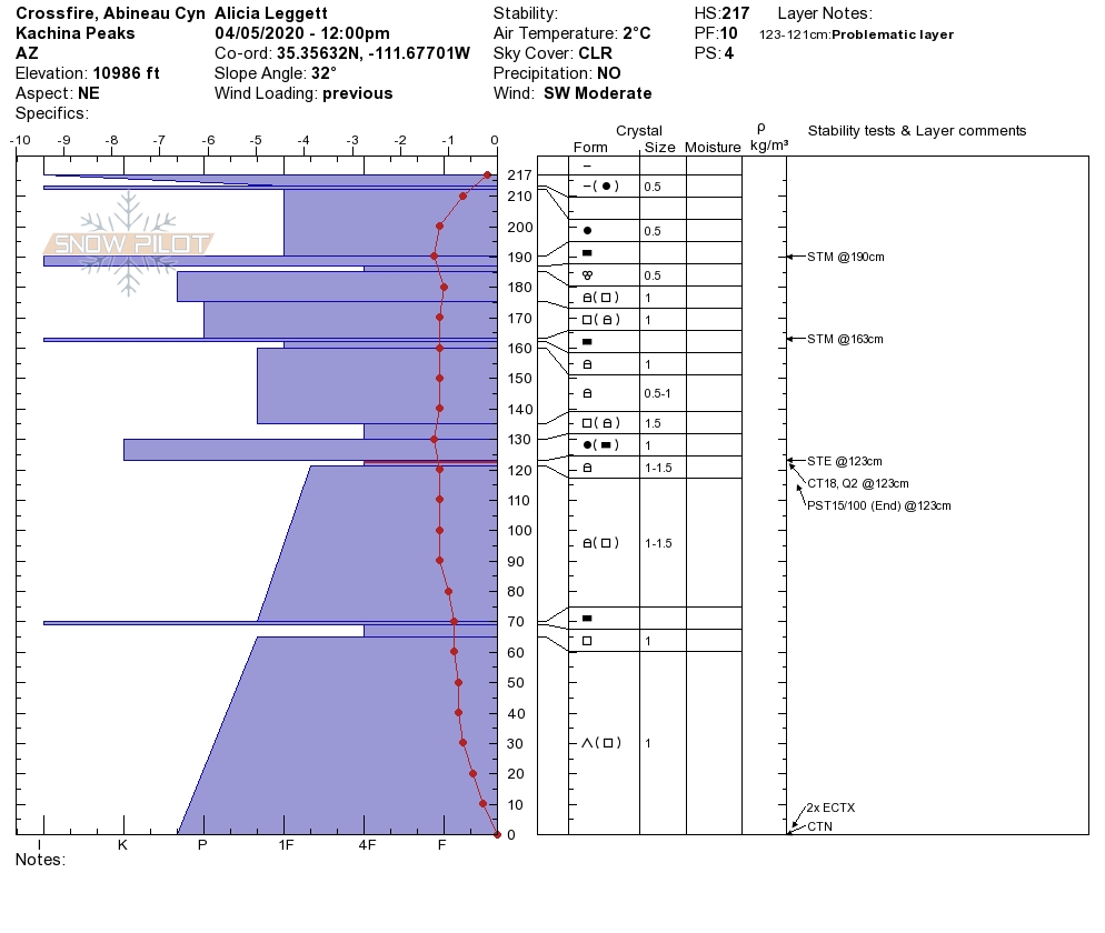
April 5 snow study pit in Abineau Canyon, by Alicia Leggett.
AZ Snowpits
Final Thoughts
KPAC is dedicated to informing the public of backcountry snow stability conditions, and providing avalanche education to winter enthusiasts.
For AZ Snowbowl access updates please refer to https://www.snowbowl.ski and www.flagstaffuphill.com.
Always carry the 10 essentials and avalanche rescue gear for wintertime wilderness travel. Submit your observations here. You may save a life!
Current conditions and long approaches require extra vigilance on the part of winter enthusiasts... be prepared, or don't go.
Weather
Unsettled gusty weather with seasonally normal temperatures prevailed on Kachina Peaks throughout last week, as a cut off low pressure system stalled over southern California’s coast. Most of the storm's energy was released as precipitation to our west in Nevada and southern California.
On Wednesday, the low moved eastward and northern Arizona received 1/2 inch of water recorded at Snowslide SNOTEL site. Most precipitation likely came in as rain, because the freeze line was relatively high; however, on Wednesday night, the snowline dropped to 7000' and the Peaks received 1-3 inches of new snow near treeline.
On Thursday night and Friday the system is expected to drift slightly southwest before ultimately dissipating, giving northern Arizona another slight chance of additional precipitation late Saturday through Monday.
As the week progresses, the jet stream shifts and a long wave trough builds to our north continuing the trend of unsettled and particularly windy afternoon weather. Precipitation, if any, is expected to be light. Looking towards next weekend, there is potential for a return of closed low pressure conditions, but timing and impact are currently too far out for an accurate prediction.
Since suspension of operations, Arizona Snowbowl is no longer reporting snow depths. Snowslide SNOTEL reports a snow depth of 47" (119cm) at 9,730 feet. So far this winter, 240" (610cm) of snowfall has been reported at 10,800 feet.
Since Friday April 3rd , SNOTEL temperatures have ranged between 51°F on April 3rd and 22°F on April 9th. ASBTP station (11,555') is not currently reporting information. Arizona Snowbowl Little Spruce (ASBLS) station (9379') reported a low of 20°F on April 9th and a high of 44°F on April 8th.
Authored/Edited By: Troy Marino, David Lovejoy, Derik Spice
Avalanche Problems/Characters
The avalanche problem/character describes part of the current avalanche danger. However because we only realease a summary once a week, the current avalanche problem will likely change.
Understanding avalanche problems is essential, because it allows you to determine your approach and strategies to risk treatment. Below are brief descriptions of avalanche problems/characters, and links to detailed information on the problem, formation, patterns, recognition, and avoidance strategies.
Avalanche Problems Explained
Also see the North American Danger Scale.
Loose Dry

Release of dry unconsolidated snow. These avalanches typically occur within layers of soft snow near the surface of the snowpack. Loose-dry avalanches start at a point and entrain snow as they move downhill, forming a fan-shaped avalanche. Other names for loose-dry avalanches include point-release avalanches or sluffs. Loose-dry avalanches can trigger slab avalanches that break into deeper snow layers.
Loose Dry avalanches are usually relatively harmless to people. They can be hazardous if you are caught and carried into or over a terrain trap (e.g. gully, rocks, dense timber, cliff, crevasse) or down a long slope. Avoid traveling in or above terrain traps when Loose Dry avalanches are likely. more info
Storm Slab

Release of a soft cohesive layer (a slab) of new snow that breaks within the storm snow or on the old snow surface. Storm-slab problems typically last between a few hours and few days. Storm-slabs that form over a persistent weak layer (surface hoar, depth hoar, or near-surface facets) may be termed Persistent Slabs or may develop into Persistent Slabs.
You can reduce your risk from Storm Slabs by waiting a day or two after a storm before venturing into steep terrain. Storm slabs are most dangerous on slopes with terrain traps, such as timber, gullies, over cliffs, or terrain features that make it difficult for a rider to escape off the side. more info
Wind Slab
Release of a cohesive layer of snow (a slab) formed by the wind. Wind typically transports snow from the upwind sides of terrain features and deposits snow on the downwind side. Wind slabs are often smooth and rounded and sometimes sound hollow, and can range from soft to hard. Wind slabs that form over a persistent weak layer (surface hoar, depth hoar, or near-surface facets) may be termed Persistent Slabs or may develop into Persistent Slabs.
Wind Slabs form in specific areas, and are confined to lee and cross-loaded terrain features. They can be avoided by sticking to sheltered or wind-scoured areas. more info
Persistent Slab

Release of a cohesive layer of soft to hard snow (a slab) in the middle to upper snowpack, when the bond to an underlying persistent weak layer breaks. Persistent layers include: surface hoar, depth hoar, near-surface facets, or faceted snow. Persistent weak layers can continue to produce avalanches for days, weeks or even months, making them especially dangerous and tricky. As additional snow and wind events build a thicker slab on top of the persistent weak layer, this avalanche problem may develop into a Deep Persistent Slab.
The best ways to manage the risk from Persistent Slabs is to make conservative terrain choices. They can be triggered by light loads and weeks after the last storm. The slabs often propagate in surprising and unpredictable ways. This makes this problem difficult to predict and manage and requires a wide safety buffer to handle the uncertainty. more info
Deep Persistent Slab

Release of a thick cohesive layer of hard snow (a slab), when the bond breaks between the slab and an underlying persistent weak layer, deep in the snowpack or near the ground. The most common persistent weak layers involved in deep, persistent slabs are depth hoar or facets surrounding a deeply buried crust. Deep Persistent Slabs are typically hard to trigger, are very destructive and dangerous due to the large mass of snow involved, and can persist for months once developed. They are often triggered from areas where the snow is shallow and weak, and are particularly difficult to forecast for and manage. They commonly develop when Persistent Slabs become more deeply buried over time.
Deep Persistent Slabs are destructive and deadly events that can take months to stabilize. You can trigger them from well down in the avalanche path, and after dozens of tracks have crossed the slope. more info
Loose Wet
Release of wet unconsolidated snow or slush. These avalanches typically occur within layers of wet snow near the surface of the snowpack, but they may quickly gouge into lower snowpack layers. Like Loose Dry Avalanches, they start at a point and entrain snow as they move downhill, forming a fan-shaped avalanche. They generally move slowly, but can contain enough mass to cause significant damage to trees, cars or buildings. Other names for loose-wet avalanches include point-release avalanches or sluffs. Loose Wet avalanches can trigger slab avalanches that break into deeper snow layers.
Travel when the snow surface is colder and stronger. Plan your trips to avoid crossing on or under very steep slopes in the afternoon. Move to colder, shadier slopes once the snow surface turns slushly. Avoid steep, sunlit slopes above terrain traps, cliffs areas and long sustained steep pitches. more info
Wet Slab

Release of a cohesive layer of snow (a slab) that is generally moist or wet when the flow of liquid water weakens the bond between the slab and the surface below (snow or ground). They often occur during prolonged warming events and/or rain-on-snow events. Wet Slabs can be very destructive.
Avoid terrain where and when you suspect Wet Slab avalanche activity. Give yourself a wide safety buffer to handle the uncertainty. more info
Cornice Fall

Cornice Fall is the release of an overhanging mass of snow that forms as the wind moves snow over a sharp terrain feature, such as a ridge, and deposits snow on the downwind (leeward) side. Cornices range in size from small wind lips of soft snow to large overhangs of hard snow that are 30 feet (10 meters) or taller. They can break off the terrain suddenly and pull back onto the ridge top and catch people by surprise even on the flat ground above the slope. Even small cornices can have enough mass to be destructive and deadly. Cornice Fall can entrain loose surface snow or trigger slab avalanches.
Cornices can never be trusted and avoiding them is necessary for safe backcountry travel. Stay well back from ridge line areas with cornices. They often overhang the ridge edge can be triggered remotely. Avoid areas underneath cornices. Even small Cornice Fall can trigger a larger avalanche and large Cornice Fall can easily crush a human. Periods of significant temperature warm-up are times to be particularly aware.
Large cornices are generally rare in Arizona, but they have been observed during very snowy winters. more info
Glide

Release of the entire snow cover as a result of gliding over the ground. Glide avalanches can be composed of wet, moist, or almost entirely dry snow. They typically occur in very specific paths, where the slope is steep enough and the ground surface is relatively smooth. The are often proceeded by full depth cracks (glide cracks), though the time between the appearance of a crack and an avalanche can vary between seconds and months. Glide avalanches are unlikely to be triggered by a person, are nearly impossible to forecast, and thus pose a hazard that is extremely difficult to manage.
Predicting the release of Glide Avalanches is very challenging. Because Glide Avalanches only occur on very specific slopes, safe travel relies on identifying and avoiding those slopes. Glide cracks are a significant indicator, as are recent Glide Avalanches.
Glide avalanches are very uncommon in Arizona. more info
